|
“Was Nagapattinam hit by a tsunami in 900 AD?”
January 02, 2005, The Times of India, India: “When high tidal waves hit India the last time before Sunday, they were not called ‘tsunami’ waves as they are now known. Ancient scriptures and literature have evidence that waves from the Indian Ocean did hit the Nagapattinam in 900 AD and destroyed a Buddhist monastery.
According to literature available in the library of the Thondaiman kingdom in Pudukottai, Tamil Nadu, it was during the reign of Raja Raja Chozha (read Chola) that waves had washed away the monastery and several temples and killed hundreds of people. There is evidence of this even in Kalki Krishnamurthy’s novel ‘Ponniyin Selvan — The Pinnacle of Sacrifice’.
In the chapter ‘The Sea Rises’, the author explains how the sea had risen so high it seemed to be touching the mass of dark clouds suspended in the sky. The black mountain of water, far from being stationary, was moving steadily forward. The sea inundated warehouses and sheds and began to flow into the streets. Ships and boats seemed suspended in mid-air, precariously poised on the water peaks.”
[Full Story]
“Catastrophic Flooding From Ancient Lake
May Have Triggered Cold Period”
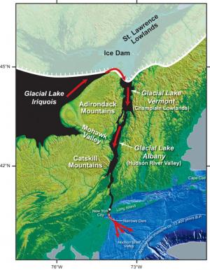
January 03, 2005, ScienceDaily, USA: “Imagine a lake three times the size of the present-day Lake Ontario breaking through a dam and flooding down the Hudson River Valley past New York City and into the North Atlantic.
The results would be catastrophic if it happened today, but it did happen some 13,400 years ago during the retreat of glaciers over North America and may have triggered a brief cooling known as the Intra-Allerod Cold Period.
|
ScienceDaily
|
|
Assistant Scientist Jeffrey Donnelly of the Woods Hole Oceanographic Institution presented the findings at the American Geophysical Union’s fall meeting in San Francisco today. Donnelly and colleagues analyzed data from sediment cores, walrus fossils and pollen to precisely date the discharge from Glacial Lake Iroquois down the Hudson River Valley at 13,350 years ago. The flood waters broke through a spot of land where the Verazanno Narrows Bridge now stands to reach the North Atlantic.
The discharge of glacial freshwater into the North Atlantic has long been thought to drive fluctuations in past climate because the huge volume of freshwater would alter thermohaline circulation in the ocean.
|
Directly linking discharge events with individual climatic changes has been difficult because of the challenges in pinpointing the location, timing and amount of the discharge.
The Intra-Allerod Cold Period lasted only about 150 years and occurred just before the Younger Dryas, a sudden cold climate period lasting some 1,200 years and ending about 11,000 years ago.”
[Full Story]
“Geography Expert Finds Lost Atlantis In Ireland”
January 06, 2005, EWorldWire, USA: “Of the several theories locating the site of Atlantis that were advanced during 2004, the hypothesis that placed it on megalithic Ireland has received the most favorable reception. This hypothesis was published by Dr. Ulf Erlingsson, an internationally renowned doctor in geography.
Though some feel that Atlantis has been desecrated by being identified with Ireland, it is this unsentimental and logical approach that led Erlingsson to his conclusion. In “Atlantis from a Geographer’s Perspective: Mapping the Fairy Land” this thesis is written in a language that captivates the reader from the beginning. It is written for anybody interested in the subject, from teenagers to white-haired professors.
Atlantis has turned into a modern myth the past century; the popular misconceptions about the lost civilization are very strong. ‘Curiously, many objections to the Ireland solution are based on sentiments that Ireland is not adequately exotic or mysterious,’ said Erlingsson. ‘As if the megalithic monuments aren’t truly remarkable enough, and as if Atlantis could possibly have been anything but Stone Age anyway.’“
[Full Story]
“Scientists study ocean to understand global cooling”
January 06, 2005, EurekAlert, USA: “The depth in the ocean where calcium carbonate dissolves at a faster rate than it is deposited is called the calcite compensation depth (CCD).
At present this depth is approximately 4,500 meters (14,700 feet) with some variation between and within ocean basins. Because the CCD is linked to ocean acidity, which is, in turn, linked to atmospheric carbon dioxide concentrations and, hence, to global climate, it is important for scientists to understand the impact of possible changes in its depth.
In the current issue of Nature, URI Graduate School of Oceanography (GSO) visiting scientist Helen Coxall describes how the deepening of the CCD in the Pacific Ocean correlated to global cooling approximately 34 million years ago, when the first significant permanent ice sheets appeared on Antarctica.”
[Full Story]
“In search of ancient tsunami”
January 07, 2005, Kauii Garden Island, Hawaii: “Tsunami researchers Dr. Walter Dudley, John Kofel and John Coney of the University of Hawai‘i at Hilo traveled to Kaua‘i in late November to seek signs of ancient and modern tsunami on Na Pali.
The team came up empty during their search, Dudley said Thursday, but hope to return to take core samples in Na Pali valleys to seek signs of tsunami.
‘We would like to organize an expedition to explore several of the valleys in order to locate sedimentary deposits left by previous tsunamis,’ Dudley said in a call to The Garden Island.”
[Full Story]
“Atlantis Poll Result: 90% Consider it Factual or Partly Factual, and 49% Place it in the Atlantic Ocean”
January 11, 2005, PRWeb, USA: “Of the poll respondents, 54% consider the Atlantis tale to be mostly factual, while only 10% consider it mostly fictional. The remaining 36% answered that it was ‘a bit of each’. Furthermore, about one half believes that Atlantis was located in the Atlantic Ocean.
The poll results contradict the claim sometimes heard that Thera (Santorini) is the most accepted hypothesis for the lost island. Only one in seven believe it was located in the Mediterranean Sea, and that includes those who believe in a location deep off Cyprus.
The online poll at AtlantisInIreland.com suggests that a large percentage of people are open-minded to the result that Ireland was the location of Atlantis. This result begs the question how it was possible for Plato to know the geography of Ireland. Hardly surprising, that is the new poll question on the website.”
[Full Story]
“The Indian Ocean Tsunami and Atlantis Linked”
January 11, 2005, PRWeb, USA: “The current disaster in the Indian Ocean that affected Indonesia (Sumatra), Thailand, India, Sri Lanka, and many islands is part of the same geological system that destroyed Atlantis, according to at least one researcher.
Most people think of Atlantis as a mythological civilization in the Atlantic Ocean, says Bill Lauritzen, an independent scholar. ‘To the ancient Egyptians, who were the first to start the Atlantis story, the Atlantic Ocean was the entire ocean surrounding Africa.’
Lauritzen points out that the Pacific Ocean was not named until 1519 by Magellan – long after the Atlantis story. Thus, other areas besides the current Atlantic Ocean should be considered as possibilities for Atlantis.
In his new book, “The Atom and the Soul”, Lauritzen claims that the Sunda Plain of Indonesia fits Plato’s Atlantis story quite well. It has elephants, coconuts, a large fertile plain, geological activity, tsunamis, a wide variety of flora and fauna, and canals. All of these elements are mentioned in Plato’s story.
The many other locations suggested for Atlantis, such as Spain, the island of Thera, Antarctica, North Africa, the Bahamas, Great Briton, and Mexico do not contain all these elements. ‘Just read Plato’s story, and make up your own mind. It’s available online,’ says Lauritzen. ‘One comes away feeling that Atlantis was somewhere in Southeast Asia. Oral tradition could have easily carried the tale of destruction to Egypt through the Red Sea. The Egyptians then told it to the Greeks.’“
[Full Story]
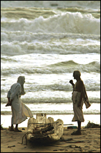
“Was ancient Indian town swallowed by tsunami?”
January 14, 2005, AOL Journals, USA: “For generations, the people of Poompuhar have spoken of the days when their sleepy fishing town was the capital of a powerful kingdom, and traders came from Rome, Greece and Egypt to deal in pearls and silk.
Then, more than 1,500 years ago, it was gone. The thriving town, according to ancient Tamil-language texts, was kodalkol’ — ‘swallowed by the sea’.
Perhaps, archaeologists and historians thought, the sea water had gradually risen. Or, some think now, perhaps it was something else.
‘Nobody knew what had happened,’ said Murugaiyan, a 38-year-old fisherman whose family has long talked of a long-gone kingdom. On December 26, though, it all became clear to him, when the tsunami slammed into coastlines across Asia and Africa.
‘Now I know,’ he said. ‘It must have been another tsunami.’“
[Full Story]
“Tiny Tuvalu is going the way of Atlantis”
January 15, 2005, IOL/Reuters, South Africa: “The islands in Tuvalu where Enele Sopoaga visited his aunts as a boy are gone, swallowed by the rising seas surrounding the Pacific archipelago.
The taro roots his family have eaten for generations grow less robustly each year due to increased salt water, and drinking water that used to be as fresh as new rain has become brackish, he said.
‘These are the indications to show us something is happening, something terrible,’ Sopoaga, Tuvalu’s ambassador to the United Nations, said on Friday.
Standing no more than four metres above sea level, many believe Tuvalu would be among the first island nations in the world to disappear as sea levels rise.”
[Full Story]
“Atlantis scientific discoveries. The Atlantis
between Spain and Morocco”
January 15, 2005, Noticias, Spain: “A Scientific Expedition has started off at the end of this summer for the area of the Straits of Gibraltar in search of possible ruins of the well-known civilization like Atlantis by Plato.
According to the ‘Atlantis Ibero-Moroccan project’, between the coasts of southwest of the Iberian Peninsula and the northwest of Africa evidences of cities or submerged coastal villages of the Bronze Age would have to be that could belong to the Island or Peninsula of Atlantis.
The expedition is directed by specialist the investigating outstanding and in languages and writings of the antiquity, Spanish-Cuban Georgeos Diaz-Montexano (1), President Founded Emeritus of the rising ‘Scientific Atlantology International Society’ (S.A.I.S.), and creator of the Proto-genesis project. Between his objectives it is the confirmation of revealers and enigmatic data found in several texts of the antiquity.”
[Full Story]
“Did Island Tribes Use Ancient Lore to Evade Tsunami?”
January 24, 2005, National Geographic News, USA: “One of the regions hardest hit by the December 26 tsunami was an extremely remote chain of more than 500 islands known collectively as the Andamans and Nicobars.
Governed by India, the archipelago separates the Bay of Bengal from the Andaman Sea. The islands are home to several hunter-gatherer tribes who until fairly recently have had very little contact with the outside world.
Anthropologists initially feared the tribes could have been completely wiped out. But Indian Air Force pilots flying sorties over the islands days after the tsunami reported seeing men who fired arrows at their helicopters. Since then there have been reports that the islanders used their ancient knowledge of nature to escape the tsunami.”
[Full Story]
“Harbor Invaders Could Trigger ‘Meltdown’ Of
Coastal Ecosystems”
January 24, 2005, ScienceDaily, USA: “A UC Davis ecologist reports today on the cautionary tale of a transplant from America’s East Coast that moved to California and lived peacefully among the natives for a half century — until a new invader radically altered the community dynamics, pushing out the natives.
The setting is the sandy bottom of Bodega Harbor, on California’s northern coast. The new arrivals, European green crabs, have accelerated the invasion of the eastern clams at the expense of native clams.
The takeover drama has implications reaching far beyond these animals, says the ecologist: It is one of the first documented cases of its kind and may portend an “invasional meltdown,” in which invaders create ecosystem changes that hasten other invasions in a positive feedback cycle.”
[Full Story]
“Book Explaining Atlantis will Come Out in Japanese”
January 29, 2005, PRWeb, USA: “Of the several theories for the location of Atlantis that were advanced during 2004, the hypothesis that Atlantis was based on megalithic Ireland probably got the most favorable reception.
It provoked supporting arguments from students of Irish mythology, archaeology, and early Egyptology. In contrast, the Cyprus hypothesis for instance was sunken quickly when several geologists refuted it based on field data.
Megalithic Ireland was identified as a major inspiration for Plato’s Atlantis in the book
“Atlantis from a Geographer’s Perspective: Mapping the Fairy Land” by Ulf Erlingsson. The author erected hypotheses and tested them using methods commonly used only in the pure sciences. In that sense, the book represents the first new hard data on Atlantis since Plato died 2,350 years ago.”
[Full Story]
“Bright Idea: Ancient monster tsunami mixed fossils”
February 01, 2005, The Albuquerque Tribune, USA: “A 65 million year old tsunami is still wreaking havoc in the scientific community, a New Mexico State University professor says.
The 300-foot-tall tsunami – an aftereffect of the giant meteor impact that some scientists think killed off the dinosaurs – scrambled fossils and rock and has made the event very hard to date, said Timothy Lawton, head of NMSU’s geology department.
‘This tsunami caused one of the biggest recycling systems the world has ever known,’ Lawton said. ‘Fossil assemblages we found from rocks related to that event in northern Mexico were a very odd mix of things that don’t belong together. The fossils don’t match the environment they’re in, making it look like the tsunami mixed them up and dragged others back into deep water from the shore.’“
[Full Story]
“Old records show tsunamis were common”
February 01, 2005, ABC News in Science, Australia: “A study of colonial records held in the UK suggests that many more tsunamis have occurred in the Indian Ocean than once thought.
Australian natural hazards expert Dr Dale Dominey-Howes, from Macquarie University in Sydney, says he has come up with the most comprehensive evidence to date that at least five major tsunamis occurred in the region since 1819.
He says his preliminary research, which will be submitted for publication, should set alarm bells ringing for the region. ‘There’s definitely a risk and we need to get a much better handle on what that risk is,’ he says.”
[Full Story]
“Concern over fate of antiquities lying on the seabed”
February 04, 2005, Kathimerini, Greece: “Experts know of more than 1,000 wrecks in Greek waters, all vulnerable to looting by antiquities thieves.
When a few months ago a leading light in the field of underwater exploration, Robert Ballard, visited Athens, he warned Greeks to guard their wrecks as if he knew what was coming.
|
Kathimerini, Greece
|
|
A bill just released by the Merchant Marine Ministry on underwater diving appears to have raised the more general issue of protecting antiquities in Greek waters. The draft legislation bans recreational diving at underwater archaeological sites.
|
However, the problem is that there are not only specifically designated sites but many others that have not yet been delineated. And because this is Greece, there is no guarantee of protection since the state is not in a position to check the looting of antiquities.
The majority of archaeologists have taken issue with the provisions of the bill, as have several environmental organizations such as the Hydra Ecologists’ Association ‘Hydran Seal’, the Society of Greek Archaeologists and even professional fishermen who claim the bill will be the coup de grace for their industry.”
[Full Story]
“Dive to discover an ancient city”
February 08, 2005, The Times of India, India: “You could soon join the search for the lost world, the Dwarka of Lord Krishna. A sports firm, bringing Gujarat’s first scuba diving project near Bet Dwarka, will combine fun and archaeology as divers can look for the Lord’s abode, considered the Holy Grail of Indian archaeology for long.
The company claims that it will be for the first time that people can dive and see an ancient submerged city. On Thursday, the Gujarat government will sign an MoU with Adventure Sports Limited, a firm working in the field of adventure sports and adventure tourism in the country, at Jamnagar.
The MoU entails two major projects — the scuba diving project off Bet Dwarka or Shankhodar, the island on which Dwarka is located now, and a centre for scuba diving in the Marine National Sanctuary. Feasibility study of the projects are awaited.”
[Full Story]
“Findings by Scripps Scientists Cast New Light
on Undersea Volcanoes”
February 11, 2005, Innovations-Report, Germany: “Researchers at Scripps Institution of Oceanography at the University of California, San Diego, have produced new findings that may help alter commonly held beliefs about how chains of undersea mountains formed by volcanoes, or ‘seamounts’, are created.
Such mountains can rise thousands of feet off the ocean floor in chains that span thousands of miles across the ocean.
|
Innovations-Report, Germany
|
|
Since the mid-20th century, the belief that the earth’s surface is covered by large, shifting plates – a concept known as plate tectonics – has shaped conventional thinking on how seamount chains develop. Textbooks have taught students that seamount patterns are shaped by changes in the direction and motion of the plates. As a plate moves, stationary ‘hot spots’ below the plate produce magma that forms a series of volcanoes in the direction of the plate motion.
|
Now, Anthony Koppers and Hubert Staudigel of Scripps have published a study that counters the idea that hot spots exist in fixed positions. The paper in the Feb. 11 issue of Science shows that hot spot chains can change direction as a result of processes unrelated to plate motion.
The new research adds further to current scientific debates on hot spots and provides information for a better understanding of the dynamics of the earth’s interior.”
[Full Story]
“Tsunami throws up India relics”
February 11, 2005, BBC News Online: “The deadly tsunami could have uncovered the remains of an ancient port city off the coast in southern India.
Archaeologists say they have discovered some stone remains from the coast close to India’s famous beachfront Mahabalipuram temple in Tamil Nadu state following the 26 December tsunami.
|
BBC News Online
|
|
They believe that the ‘structures’ could be the remains of an ancient and once-flourishing port city in the area housing the famous 1200-year-old rock-hewn temple.
Three pieces of remains, which include a granite lion, were found buried in the sand after the coastline receded in the area after the tsunami struck.
|
‘They could be part of the small seaport city which existed here before water engulfed them. They could be part of a temple or a building. We are investigating’, says T Sathiamoorthy of Archaeological Survey of India (ASI).
Archaeologists say that the stone remains date back to 7th Century AD and are nearly 6ft tall. They have elaborate engravings of the kind that are found in the Mahabalipuram temple.”
[Full Story]
“Seabed at tsunami’s center shows ruptures”
February 11, 2005, Anchorage Daily News, Alaska: “The first images of the seabed that was rocked by the earthquake that triggered Asia’s catastrophic tsunami revealed huge ruptures spanning several miles along the Indian Ocean’s floor.
|
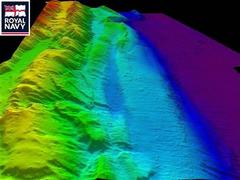
AP/Royal Navy
|
|
The United States, meanwhile, said it was preparing to more than double its pledge for tsunami relief to $950 million.
The images of the seabed were from a British naval ship collecting data off the coast of Indonesia’s Sumatra Island that could be used to help governments develop a tsunami early warning system for the Indian Ocean region.
|
‘There are features which we would think are something like the Grand Canyon would look’, Tim Henstock, a scientist aboard the HMS Scott, told BBC News. ‘You can see huge piles of mud maybe a few hundred meters (yards) thick.’.
The images show ‘slide scars’ more than six miles wide resulting from the 9.0 magnitude quake on Dec. 26, the world’s biggest in 40 years.”
[Full Story]
“Tsunami’s gift to archaeologists”
February 11, 2005, Cape Argus, South Africa: “The deadly tsunamis that crashed into southern India unearthed priceless relics, including two granite lions, that had lain buried under the sand for centuries, archaeologists say.
A team from the Archaeological Survey of India descended on the ancient seaport of Mahabalipuram, 70 kilometres south of Madras, to examine the ‘gifts’ left after the tsunami redrew the entire coastline.
They include the remnants of a stone house and a half-completed rock elephant, archaeologists said late yesterday. There are also two giant granite lions, one seated and another poised to charge. The statues are each carved out of a single piece of granite stone, testifying to the carver’s skill.
The objects were uncovered when the towering waves withdrew from the beach, carrying huge amounts of sand with them.”
[Full Story]
“Ancient tsunami scrambled the fossil record”
February 12, 2005, New Scientist, UK: “One of the few remaining objections to the idea that an asteroid killed off the dinosaurs has been put to rest. The giant tsunami caused by the impact may have scrambled fossil evidence, explaining puzzling finds that suggested the asteroid and the mass extinction were unrelated.
Many geologists have long argued that the Cretaceous period ended when a 10-kilometre-wide asteroid slammed into the Gulf of Mexico, just off the Yucat´n coast.
That point in history bears the hallmarks of a global disaster – mass extinction, a giant crater, impact debris such as solidified rock droplets, and traces of iridium typical of an asteroid.
However, fossils from the end of the Cretaceous have been found above layers of rock linked to the asteroid impact, and Gerta Keller of Princeton University has used this evidence to argue that the extinction may have come 300,000 years after the impact.”
[Full Story]
“Tsunami may have revealed lost city”
February 14, 2005, New Zealand Herald, New Zealand: “The mighty Boxing Day tsunami has revealed what archaeologists believe to be the lost ruins of an ancient city off the coast of Tamil Nadu in southern India.
|
New Zealand Herald
|
|
The 30-metre waves, which reshaped the Bay of Bengal and swept more than 16,000 Indians to their death, shifted thousands of tonnes of sand to unearth a pair of elaborately carved stone lions and a stallion near the famous 7th century Dravidian temple on the coast at Mahabalipuram, south of Madras.
Indian archaeologists believe these granite beasts once guarded a small port city that may have been submerged since the last Ice Age.
|
The 2-metre high lion statues, each hewn from a single piece of granite, appear breathtakingly lifelike. One great stone cat sits up alert while the other is poised to pounce. Two man-made foundation walls also remain visible beneath the murky waters, now measurably shallower. .
The tsunami also de-silted a large bas-relief stone panel that had been buried in sand for centuries, close to the shore temple.”
[Full Story]
“Getting to the bottom of ancient mere”
February 16, 2005, EDP24, England: “Diss Mere could be much older than previously thought, according to the findings of a new survey.
Last April, scientists from University College London led a team from Cambridge University and the Open University in prodding and probing the Mere’s waters to produce a three-dimensional model of its depth.
The results suggest that the Mere is much older than the current thinking of about 12,000 years. There could also be more examples along the Waveney Valley which have now filled up completely.
After surveys in 1980, Diss Mere was said to be the second deepest natural lake in Britain, with some saying there was evidence of a channel across its bed, possibly the source of an ancient stream.”
[Full Story]
“Underwater arrowheads, tools dazzle Maritime historians”
February 17, 2005, CBC News, Canada: “Archaeologists are showing off a treasure trove they call one of the most significant discoveries of Mi’kmaq artifacts in Nova Scotia. Hundreds of arrowheads and tools, some 8,000 years old, were discovered last summer along the Mersey River, near Kejimkujik National Park in the southwest region of the province.
|

CBC News, Canada
|
|
Workers from Nova Scotia Power were doing repairs to generating stations on the river. As water levels dropped in some areas, the riverbed was exposed for the first time since dams were built 70 years ago.
Suddenly hundreds of artifacts appeared in the mud.
‘The quantity of material, the quality of material, the age range represented by the material, all is just fascinating for us,’ said archaeologist Bruce Stewart, who was hired to investigate.
|
Pottery fragments, spear points, knives and other items were found around 109 ancient campsites. One barbed harpoon was once used to spear salmon and eels 3,000 years ago, Stewart said.
Since the artifacts were lying on the surface, the RCMP was brought in to control looting. Even the discovery was kept a secret.”
[Full Story]
“ASI team at Mamallapuram to locate pagodas”
February 17, 2005, Chennai Online, India: “In a bid to locate some eighth century pagodas, a team of archaeologists from the Archaeological Survey of India (ASI) today began a joint operation with the Indian Navy at Mamallapuram, about 50 km from here.
Confirming this, ASI superintending engineer T Sathyamurthy said the exploration, for which the Union government has sanctioned Rs 12 lakh, for the pagodas would go on for a month.
The archaeologists have identified the possible area where the pagodas were located, which was between 500 metres and 1,000 metres from the famous and ancient Pallava period shore temple of Mamallapuram (Mahabalipuram), Sathyamurthy said.”
[Full Story]
“Ancient city uncovered by tsunami”
February 18, 2005, Glasgow Evening News, Scotland: “Archaeologists have begun underwater excavations of what is believed to be an ancient city and parts of a temple uncovered by the Indian Ocean tsunami off the coast of a centuries-old pilgrimage town 30 miles south of Madras.
Three rocky structures with elaborate carvings of animals have emerged near the coastal town of Mahabalipuram, battered by the December 26 Asian tsunami.
As the tsunami’s waves receded, the force removed sand deposits that had covered the structures, which appear to belong to a port city built in the seventh century.”
[Full Story]
“Scientists find tsunami produced 90-foot wave”
February 18, 2005, San Francisco Chronicle, USA: “In the minutes following December’s catastrophic earthquake off the Indonesian island of Sumatra, a surge of seawater more than 90 feet high inundated stretches of the remote western coast.
A wave of such biblical proportions would crest as high as the clock on San Francisco’s Ferry Building.
When the tsunami hit the island nation of Sri Lanka hours later, it displaced 2 million cubic yards of sand – enough to bury a football field 1, 000 feet deep.
These are some of the early and jaw-dropping observations of an American team of scientists who recently returned from the disaster zone.”
[Full Story]
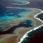
“Ancient mangrove forests found under reef”
February 23, 2005, ABC News Online/Reuters, Australia: “North Queensland marine researchers have opened a window into the past by exposing ancient mangrove forests entombed beneath the Great Barrier Reef.
|
ABC News Online/Reuters
|
|
Dr Dan Alongi from the Australian Institute of Marine Science says they have unearthed 9,000-year-old mangroves in old river channels that were swamped when sea levels rose after the last ice age.
He says the relic mangroves show an abrupt rise in the sea level, 20 times faster than previously thought.
|
‘Material was very much intact, it didn’t even have time to fully decompose when it was buried, so it does tell us that when climate change happened at least when it happened in the past it was comparatively quick,’ he said.”
[Full Story]
“Coral reef clue to fast sea rise”
February 24, 2005, The Guardian, UK: “The discovery of ancient mangrove forest remains under the Great Barrier Reef has cast doubt on some theories about how quickly the sea level rose after the last ice age.
Most scientists believe it was a gradual rise over the past 9,000 years. But the existence of relic mangroves 70cm (27in) below the floor of the Barrier Reef, some with leaves and branches still intact, suggests an abrupt rise.
Dan Alongi, a biologist at the Australian Institute of Marine Science, said it appeared that sea levels rose about 3 metres in less than 30 years, drowning forests and flooding estuaries, 20 times faster than previously thought.”
[Full Story]
“Tsunami unveils ‘seven pagodas'”
February 25, 2005, The Times of India, India: “Call it a blessing in disguise. Or a tsunami surprise. The trail of destruction has given a ray of hope to archaeologists in this temple town, who are already on an exciting excavation mission. And, the big question: Is the legend of seven pagodas coming to a reality?
As the killer tsunami waves receded, it also gulped the sand deposits only to unveil a line of rocks 500 metres from the Shore temple. The neat arrangement of rocks with man-made features could turn out to be another cave temple of the Pallava era (8th century).
The naval diving team, assisting the Archaeological Society of India, also discovered another structure — perhaps a temple 100 metres north-east.
‘The sonar system indicates that there are structures under the sand and sea. We are exploring it. We are also exploring the exposed relics on the shore,’ says superintending archaeologist T Sathyamurthy.
The excavations of the existing temple are being supervised by ASI underwater archaeology wing (Delhi), deputy superintending archaeologist Alok Tripathi.
‘I can tell you where the walls and the main building structures are. Only after the structure is exposed, can we tell you if it’s a temple or a housing structure. The tsunami has given us a new angle to find how these structures were buried,’ he said. So far, his team has found a round gopuram-shaped top and rocky walls.”
[Full Story]
“Underwater find in tsunami region – Structures off TN coast may answer questions about Seven Pagodas”
February 26, 2005, The Calcutta Telegraph, India: “Among the few strange acts of the killer tsunami was blowing the sand cover off seven boulders with various carved figures on the coast of this ancient town.
|
The Calcutta Telegraph, India
|
|
Off the coast now, archaeologists have found several ‘promising structures’ that have kindled hopes of cracking a long-standing mystery about the Seven Pagodas described by western scholars in and around Mamallapuram, 55 km from Chennai.
|
‘We find some man-made structures, some wall-like structures, some step-like structures, besides perfectly cut stone blocks arranged in a pattern,’ said Alok Tripathy, a senior official of the Archaeological Survey of India (ASI).
The underwater discovery lies close to the Shore Temple, reviving the question asked by historians, archaeologists and seafarers from time to time if they are all part of a once-existing complex of seven temples.”
[Full Story]
“Scientists find submerged forest under Qld seabed”
February 26, 2005, ABC Radio News, Australia: “Scientists have spent the past few days looking at something disturbing under the sea bed off the far north Queensland coast. They’ve found the remains of a forest that drowned at the end of the last ice age, around 9,000 years ago.
What worries them is that the trees appear to have been swamped when sea levels rose fast, as much as five metres in just 20 years. If it’s true, it means that the world’s climate changed wildly within a human lifetime in the past, and it could happen again.
A research ship is anchored today off a group of small islands south of Cairns. Aboard are scientists with the Australian Institute of Marine Science, who’ve been on a mission to map the life on the seabed along the length of the Great Barrier Reef.
Also aboard the research vessel Lady Basten is Dr Dan Alongi, who’s been looking at nutrients in sediment as part of this survey. A few years ago scientists drilled a core in the seabed in this area, south of Cairns, and it came up with the usual reef sand, as well as a layer of dead trees… bear in mind that these dead trees were found 10 to 15 kilometres offshore.”
[Full Story]
“Ancient artefacts retrieved from seabed near Chennai”
February 26, 2005, WebIndia123, India: “Archaeologists have discovered relics of an ancient era off India’s Chennai’s coast. The relics were found near Mahabalipuram, 50 kilometers from here.
The present search operation was a follow up to the recent discovery of a silted up Pallava sculpture, dating to seventh century AD, that was revealed on the beachfront as the water of the December 26 tsunami receded. Some of the recovered relics included pieces of pottery.
‘There has been extensive diving going on for about two weeks from the 11th to the 25 of February. For the first three or four days the weather was extremely bad and nothing much could be done. However the last 10 days have been very fruitful,’ Commodore Brian A. Thomas, Principal Director of Special Operations (Diving) of the Indian Navy, told reporters here.
A joint team of the Indian Navy and the Archaeological Survey of India (ASI) carried out the offshore and onshore explorations.”
[Full Story]
“Indian archaeologist divers discover ancient port city
in south India”
February 27, 2005, Khaleej Times, United Arab Emirates:
“Indian archaeologists have found what they believe are undersea ‘stone structures’ that could be the remains of an ancient port city off India’s southern coast, officials say.
The archaeologists learnt of the structures after locals reported spotting a temple and several sculptures when the sea pulled back briefly just before deadly tsunamis smashed into the coastline December 26.
Divers discovered the stone remains close to India’s famous beachfront Mahabalipuram temple in Tamil Nadu state, Alok Tripathi, an official from the state-run Archeological Survey of India (ASI), said on Saturday.
‘We’ve found some stone structures which are clearly man-made. They’re perfect rectangular blocks, arranged in a clear pattern,’ he said aboard the Indian naval vessel ‘Ghorpad’.”
[Full Story]
“Is something lurking in Lake Washington?”
March 01, 2005, Seattle P-I, USA: “Is it a croc or a crock? Are razor-toothed reptiles patrolling the waters of Lake Washington? Or has a new suburban legend sprung to life?
Medina wants to know; so does Mercer Island. So do the men and women of law enforcement in both towns.
It was just Wednesday that two reports came in to Medina police that described a shape that looks like ‘the head of an alligator’ near the docks in Lake Washington’s Fairweather Bay.
No Bigfoot. No Loch Ness Monster. Not even a critter befitting the descriptions of ancient Indians, whose legends had spotted, horned serpents and other assorted monsters living in the lake.”
[Full Story]
“New crocodile species helps prove land links”
March 01, 2005, The Boston Globe, USA: “A unique, nearly complete fossilized skeleton of a prehistoric crocodile found in Brazil backs up theories that there were land links between South America and Madagascar about 70 million years ago.
Presenting the new species last month, professor Ismar de Souza Carvalho of Rio de Janeiro Federal University said the Uberabasuchus terrificus, or the terrible crocodile of Uberaba, shed light on the splitting of the ancient supercontinent known as Gondwana following Africa’s breakaway.
Similar crocodiles have been found in Argentina and Madagascar, he said.
Scientists believe Africa broke away from Gondwana – the massive continent grouping Australia, India, Africa, South America and Antarctica – more than 100 million years ago but a connection still existed between what is now South America, Antarctica, India and possibly Australia until about 70 million years ago.”
[Full Story]
“Is Atlantis Off The Shore Of Cuba?”
March 05, 2005, Free Internet Press, USA: “The images appear slowly on the video screen, like ghosts from the ocean floor. The videotape, made by an unmanned submarine, shows massive stones in oddly symmetrical square and pyramid shapes in the deep-sea darkness.
Sonar images taken from a research ship 2,000 feet above are even more puzzling. They show that the smooth, white stones are laid out in a geometric pattern. The images look like fragments of a city, in a place where nothing man-made should exist, spanning nearly eight square miles of a deep-ocean plain off Cuba’s western tip.
‘What we have here is a mystery,’ said Paul Weinsweig, of Advanced Digital Communications (ADC), a Canadian company that is mapping the ocean bottom of Cuba’s territorial waters under contract with the government of President Fidel Castro.
‘Nature couldn’t have built anything so symmetrical, Weinzweig said, running his finger over sonar printouts aboard his ship, tied up at a wharf in Havana harbor. ‘This isn’t natural, but we don’t know what it is.’“
[Full Story]
“Atlantis is a Utopia — Now Scientifically Proven”
March 05, 2005, PRWeb, USA: “A recently published book presents the first hard evidence on Atlantis since Plato died 2,350 years ago. It is written for scholars but is also accessible for the general public.
After proving that Plato was describing Ireland, the author discusses other data such as the temples, and the final disaster when it sank in the sea. His conclusion is that it is a tall tale composed of elements from different times and places.
In the book
“Atlantis from a Geographer’s Perspective: Mapping the Fairy Land”, Dr. Ulf Erlingsson proves that Plato based the geography of Atlantis on that of Ireland. The level of certainty is 99.98%. Since many other details obviously do not match Ireland — such as that Atlantis sank in the sea — it follows that Atlantis really was a Utopia, that is, it didn’t exist anywhere such as described”
[Full Story]
“Brunei’s Sunken Treasures Return Home After Oz Trip”
March 07, 2005, Brunei Direct, Brunei Darussalem: “Around 500 artefacts from the sunken treasures of Brunei made its way back to the shores of Brunei after a successful four-month exhibition tour around Australia.
Accompanying the artefacts back to Brunei were two Australians, Mr Dick Richards, the Curator of Brunei Ship Exhibition in Australia, and Mr Michael Jones, the Manager of the Brunei Ship Exhibition in Australia. Both possess an in-depth knowledge of Brunei’s sunken treasure and are here to assist in the unpacking and recording process of the returning artefacts.
More than 200,000 people had visited the exhibition, which showcased artefacts from Brunei’s sunken ship, he said, adding that the exhibition has helped Australians understand Brunei’s culture and customs.
Aside from the display of artefacts such as bronze cannons, gongs and water vessels, there were also video presentations on how the artefacts were excavated. There were also talks by divers who assisted in the retrieving of the artefacts from sea.”
[Full Story]
“Underwater survey under way for Lewes artifacts”
March 07, 2005, Cape Gazette, USA: “Divers could begin searching for the source of artifacts in waters near the Roosevelt Inlet in Lewes in the next couple of weeks, after crews spent several days this week scanning the bay bottom with remote sensing instruments.
Dolan Research Inc., an underwater archaeological survey company based in Newtown Square, Pa., is conducting bottom surveys of the area using a magnetometer, or metal detector; side-scan sonar; and a sub bottom profiler, a type of sonar that maps the bay bottom.
‘This will help us get a good, three-dimensional look at the borrow area and the whole area that was borrowed from and that could be borrowed from,’ said Craig Lukezic, a state archaeologist working on the project.
Lukezic said the Dolan research vessels are using instruments to sweep the waters near the inlet in a tight pattern so that as much of the dredge site as possible is covered in the survey.”
[Full Story]
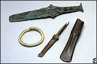
“Divers find Bronze Age axe”
March 09, 2005, The Daily Telegraph, UK: “Divers have discovered a hoard of Bronze Age artefacts including swords and rapiers off the Devon coast.
|
The Daily Telegraph, UK
|
|
The items are thought to come from an ancient shipwreck.
The swords are among the earliest found in north-west Europe, and the find also includes a gold bracelet, a cauldron handle, an axe head and an adze.
|
The objects, now being studied at the British Museum, were discovered last summer off Salcombe by the South West Maritime Archaeology Group.”
[Full Story]
“Divers find Bronze Age treasure”
March 09, 2005, Herald Sun, Australia: “Archaeologists have discovered a treasure of Bronze Age objects during a diving expedition off the south-west coast of England, a spokesperson for the British Museum said today.
The objects, dating from the 13th century BC include; swords, rapiers, an adze, a gold bracelet, the head of an axe and the handle of a cauldron.
They were found last summer off the coast of Salcombe, in the county of Devon, by the members of the Maritime Archaeology group, which has made a number of important discoveries during the last 15 years.”
[Full Story]
“Mahabalipuram could have more than one temple”
March 12, 2005, WebIndia123, India: “For centuries, the magnificent rock temple at Mahabalipuram near Chennai has stood as an eternal reminder of the architectural skill of its builders. It now emerges that there could be more than one temple – offshore and onshore.
It’s still early days before passing a judgment but excavations around the temple conducted jointly by the Indian Navy and the Archeological Survey of India (ASI) reveal that there could be some truth to the area being referred to as the “Land of the Seven Pagodas”.
The findings of the exploration ‘have been promising and are being minutely analysed by ASI professionals’ and will be presented at the second International Seminar on Marine Archeology to be held here March 18-19, the Indian Navy deputy chief, Vice Admiral Sureesh Mehta, told reporters here.”
[Full Story]
“US sues shipwreck divers in bid to recover artifacts”
March 12, 2005, The Boston Globe, USA: “The federal government took a group of divers to court yesterday and demanded the return of artifacts recovered from a deadly 1934 shipwreck 50 miles south of Nantucket.
The US Justice Department had filed a civil suit alleging that divers belonging to a group called the Boston Sea Rovers salvaged items last year from the Lightship Nantucket (Vessel 117), even though the Coast Guard had warned them in 1999 not to disrupt the underwater gravesite.
The vessel, which belonged to the US Lighthouse Service and flashed a beacon to warn ships that they were approaching Nantucket Shoals, was rammed in heavy fog on May 15, 1934, by the British White Star luxury liner SS Olympic, the sister ship to the Titanic. Four sailors went down with the ship, and their remains were never recovered. Three people on the Olympic died.”
[Full Story]
“Next stop Atlantis, Cuba”
March 15, 2005, Canada Free Press, Canada: “Long-ago Greek philosopher Plato may have unwittingly unleashed a modern day political Battle Royale on an unsuspecting world with his haunting tales of the lost city, Atlantis.
Untold legions took to heart the philosopher’s lament that ‘earthquakes and floods ‘in `one terrible day and night’ destroyed his Atlantic island empire.
Drama in writing style was not lost on this student of Socrates, who recorded his thoughts post-8570 BC in the TIMAEUS and circa 9421 BC in the CRITIAS.
Now a ‘lost city’, that could be the fabled city of Atlantis, has been discovered by a Canadian scientific research team, off the western coast of Cuba.”
[Full Story]
“Undersea earthquake moved islands – experts”
March 16, 2005, IOL, South Africa: “Three popular beach resorts were among seven islands on India’s Andamans archipelago that shifted southwestwards when a giant earthquake hit on December 26, geologists said on Wednesday.
The state-run Centre for Earth Science Studies (CESS) found that six inhabited islands and one which boasts a volcano had moved ‘a few metres’ after the undersea quake that triggered deadly tsunamis.
‘Preliminary estimates from the GPS (global positioning satellite systems) survey around Andaman and Nicobar suggest the islands have shifted southwestward by a few metres,’ CESS seismologist CP Rajendran told reporters.
‘Also some parts of the Andaman and Nicobar islands subsided and some got uplifted,’ the study said, adding that eastern districts of the Andamanese capital Port Blair sank deeper into the sea after the tremors shook the 550 volcanic islands.”
[Full Story]
“Tsunami fuels talk of Indian Atlantis”
March 18, 2005, The Globe & Mail, Canada: “For a few minutes, after the water had receded far from shore and before it came raging back as a tsunami, the fishermen stood along the beach and stared at the reality of generations of legends.
Or so they say. Spread across a kilometre, the site was encrusted with barnacles and covered in mud. But the fishermen insist they saw the remains of ancient temples and hundreds of refrigerator-sized blocks, all briefly exposed before the sea swallowed them up again.
‘You could see the destroyed walls covered in coral, and the broken-down temple in the middle,’ said Durai, a sinewy fisherman who uses only one name, like many south Indians. ‘My grandfathers said there was a port here once and a temple, but suddenly we could see it was real. We could see that something was out there.’“
[Full Story]
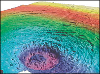
“North Sea crater shows its scars”
March 18, 2005, BBC Science News, UK: “What is thought to be the UK’s only space impact crater has been mapped in detail in 3D for the first time.
|
BBC Science News, UK
|
|
The so-called Silverpit structure lies several hundred metres under the floor of the North Sea, about 130km (80 miles) east of the Yorkshire coast.
The new pictures show a spectacular set of rings sweeping out around a 3km-wide (1.8 miles) central hole.
|
Researchers report their description and interpretation of the images in the Geological Society of America Bulletin.”
[Full Story]
“Deep in the oceans, where it’s dark and hot,
primitive life teems”
March 21, 2005, San Francisco Chronicle, USA: “Deep beneath the oceans of the world, in the cold and dark where sunlight never penetrates, scientists are discovering that deep clefts in half- molten rock are teeming with life – vast populations of primitive microscopic organisms that thrive on the intense heat, obtain their energy from chemicals alone, and provide food for other creatures higher up the sea’s food chain.
Down there, great slabs of the Earth’s crust are heaving and splitting apart. Viscous rock thrusts up from the mantle beneath to create networks of conduits where seawater circulates at brutally hot temperatures.
n some places, undersea volcanoes spurt lava onto the sea floor from the crests of long ridges that mark the crustal gaps, or ‘spreading centers’ as they’re called. Scientists have only recently found that hillsides in the abyss miles from the spreading centers also vent volcanic heat – and harbor wide varieties of microbes.”
[Full Story]
“Underwater team explores ocean floor”
March 23, 2005, The Chronicle, USA: “It is an environment that is strange, bizarre and altogether alien. At the exotic locale of Pito Deep, a crew of researchers from Duke, the University of Hawaii and six other institutions studied the ocean floor near Easter Island and Tahiti from Jan. 30 to March 8.
Penetrating the unexplored—to places that even light cannot—the crew led by Jeff Karson, a professor of geology at the Nicholas School for Environment and Earth Sciences, is beginning to unravel the earth’s geological history.
‘Pito Deep is one of the few places on the seafloor where we can learn directly about the rocks in the subsurface,’ Karson wrote in an e-mail from the Pito Deep Cruise in the South Pacific Ocean.”
[Full Story]
“The Dragon in the Lake – New Book Reveals Latest Research
on the Ancient Underwater Pyramids in Wisconsin”
March 29, 2005, PrimeZone, USA: “In the cold murky depths of a Wisconsin lake lay mysterious rock structures wrapped in Native American folklore and local legend.
These ancient underwater manmade structures may be the most significant and controversial North American archeological discovery of the twentieth century.
In Archie Eschborn’s fascinating new book “The Dragon in the Lake”, you will follow a small band of amateur archeologists led by Eschborn himself as they reveal new research opening up a new chapter in prehistoric North American history and ending decades of controversy on North America’s most sacred and secret native American site.”
[Full Story]
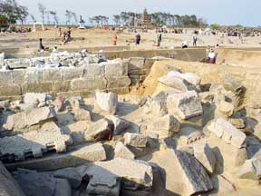
“ASI: More structures near shore temple under water”
April 01, 2005, News Today, India: “The recent onshore and offshore excavations undertaken by the Archaeological Survey of India (ASI) and the Navy along the Mamallapuram area have revealed that there were evidences of two temples near the shore temple and some more temples onshore.
|
News Today, India
|
|
Alok Tripathi, deputy superintending archaeologist, ASI and leader of the excavation team, told mediapersons yesterday that the two temples existed at the south of the shore temples.
Going by the evidence available these two temples seemed to be different from the shore temple and not part of it, he said.
|
After the survey of area it is concluded ‘with certainty that some more structures existed near shore temples and their remains lay under water’, he said.
To confirm initial findings and to understand the changes in coastline or sea level fluctuation during historic period, the excavations are being carried out close to the shore temple.”
[Full Story]
“Tsunami theory of flood disaster”
April 04, 2005, BBC News Online, UK: “A tsunami in the Bristol Channel could have caused the deaths of up to 2,000 people in one of Britain’s greatest natural disasters, experts have said.
|
BBC News Online, UK
|
|
For centuries, it has been thought that the great flood of January 1607 was caused by high tides and severe storms.
It is estimated 200 square miles (520 sq km) of land in south Wales and south west England were covered by water.
|
In a BBC Timewatch programme, two experts have argued a tsunami could have caused the devastation.
Eyewitness accounts of the disaster, published in six different pamphlets of the time, told of ‘huge and mighty hills of water’ advancing at a speed ‘faster than a greyhound can run’ and only receding 10 days later.”
[Full Story]
“BSAC offers Maritime Archaeological
training course in Philippines”
April 06, 2005, DeeperBlue, UK: “This is a unique opportunity to be the first to do an archaeological survey training course in a beautiful hot and historical location. BSAC and the Anglo-Danish Maritime Archaeological Team are holding a training course as part of the London Regional Expedition Diving Scheme for 2005.
This project will take place between 16th-30th April and 20th April – 14th May 2005. Applications are invited from divers, students, archaeologists and volunteers wishing to participate in the project.
The Philippines were an important trading centre for the ancient Chinese and Spanish and many ships were perished in the Typhoons.
The training programme will teach people how to survey for shipwrecks going on to use the learnt skills to uncover a local mystery as to why 16th century Chinese pottery shards are being found.”
[Full Story]
“Research Team Recreates Ancient Underwater
Concrete Technology”
April 07, 2005, Azom, USA: “A University of Colorado at Boulder professor and his colleagues have taken a page from the writings of an ancient Roman architect and built an underwater concrete pier in the manner of those set in the Mediterranean Sea 2,000 years ago.
CU-Boulder history Professor Robert Hohlfelder, an internationally known underwater archaeologist, said scholars have long been in awe of the engineering feats of the early Romans.
A former co-director of the international Caesarea Ancient Harbor Excavation Project, he said the research effort was spurred by the stunning hydraulic concrete efforts undertaken at Caesarea Harbor in present-day Israel and elsewhere in the Mediterranean before the time of Christ.
Hohlfelder, who teamed up on the project with London architect and archaeologist Christopher Brandon and Greek and Roman Studies Professor John Peter Oleson of Canada’s University of Victoria, said the writings of ancient Roman Pollio Vitruvius provided a key starting point.
Vitruvius published 10 books on architecture circa 25 B.C. describing the building and engineering methods practiced during the Roman Empire, including ancient harbor construction.”
[Full Story]
“Archaeologists discount claims about Queen Anne’s Revenge”
April 10, 2005, Sun-Journal, USA: “A picture on the presentation screen showed one of the cannons state archaeologists retrieved from a shipwreck they think might be the pirate Blackbeard’s flagship.
Those attending a symposium on the archaeological project could read the numbers ‘1730’ written on the side of the barrel.
‘Anybody that says that’s a date is really showing their ignorance of 18th Century cannon foundry,’ said Nathan Henry, archaeological conservator with the state’s Underwater Archaeology Branch.
Instead, Henry said, the figures refer to the weight of the gun.
His comments referred to the authors of an article in the April edition of the International Journal of Nautical Archaeology that cites the numbers on the cannon as possibly the most important of several reasons to question whether the shipwreck truly is the Queen Anne’s Revenge.”
[Full Story]
“Archaeologists Debate Whether Ship Was Blackbeard’s”
April 11, 2005, WFMY News, USA: “What do those numbers “1730” on a cannon retrieved from a shipwreck that state archaeologists think is the flagship of the pirate Blackbeard really mean? A year? A weight?
|
WFMY News, USA
|
|
That’s part of the argument about whether the shipwreck really is Queen Anne’s Revenge. That’s the ship that historical accounts say Blackbeard intentionally sank near Beaufort in June 1718 to break up his company of 300 to 400 men.
At a symposium at East Carolina University those who believe it is defended their work.
|
State archaeological conservator Nathan Henry says founders of that day used professional engravers to mark the cannons they made.
But he says those numbers are chiseled and more likly refer to the gun’s weight.”
[Full Story]
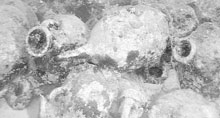
“Ten Parthian Casks Discovered in Rig Port Waters”
April 11, 2005, The Persian Journal, Iran: “Ten casks dating to the Parthian times have been discovered in the waters of Rig Port in the southern province of Boushehr.
The casks were primarily used for burying the dead, and then for some 1000 years (before the Islamic dynasty of Abbasids started to rule Iran) for trade and transfer of wine.
The underwater archaeology team of Iran recently discovered 10 casks in Rig Port coastal waters. Most of these casks are broken down, and only one remains intact. This type of cask has been the main container of liquids in Ancient Iran.
‘Several items including headpieces, armors, and stone anchors were discovered during the first season of exploration in Rig waters. The archaeology team therefore decided to focus their work on documentation, photography, and filming of the explored sites,’ explained head of the exploration team, Hussein Tofighian.
Meanwhile the site was studies furthermore and several casks were found there, added Tofighian. “
[Full Story]
“New methods help find and preserve ancient wrecks”
April 12, 2005, Kathimerini, Greece: “A new search is under way to find the wreckage of an ancient Persian fleet on the seabed off the coast of Greece.
In cooperation with the Center for Maritime Research that has found over 30 wrecks within five years, the Ephorate of Coastal Antiquities, with the help of American and Canadian experts, will resume their search in June in the areas of Kili and Artemisio, off Evia’s northern tip.
|
Kathimerini, Greece
|
|
Amphorae from one of some 1,000 wrecks known to exist in Greek waters.
Technological developments are making it easier for archaeologists to find and evaluate marine antiquities.
|
Despite the ephorate’s modest budget (this year’s is unchanged from last year’s at 400,000 euros), exploration will be expanded to cover the seabed off the coast of Inousses island in a pilot program on the 3D imaging of an ancient wreck.
Archaeological maritime exploration has contributed to the development of technology for preserving wrecks found in the sea and to methods of preserving antiquities.”
[Full Story]
“Planetary alignment caused tsunami, says a scientist”
April 16, 2005, Deccan Herald, India: “The deadly tsunami on 26 December, 2004 was the result of Saturn, Moon, Earth and the Sun falling in a straight line, claims a retired scientist of Department of Atomic Energy.
Paramahamsa Tewari, who supervised construction of Narora and Kaiga atomic plants and authored controversial ‘space vortex theory’, says his conclusion about the cause of tsunami stems from his theory that all spinning cosmic objects including the Sun develop electrical fields that repel each other.
On the fateful day, Saturn, Moon, Earth and the Sun were perfectly aligned. As a result, Earth was subjected to the repulsive electrical force of the Sun on one side.
But the balancing force on the other side due to Saturn was very much reduced as it was shielded by the Moon which does not spin and therefore has no electrical repulsive force on its own, he claims.”
[Full Story]
“Artifact looting on the rise as Lake Oahe level falls”
April 17, 2005, Grand Forks Herald/AP, USA: “As Lake Oahe inches toward a record low, the falling water is revealing artifacts of the past, ranging from concrete burial vaults of recent history to ancient Plains relics from thousands of years ago.
Scattered across thousands of acres of normally submerged land, the pieces – arrowheads, pottery shards and personal items associated with human remains – are easily accessible to artifact hunters, according to Rick Harnois, a senior field archaeologist with the U.S. Army Corps of Engineers.
‘The lower the water gets, the more land we have to manage and the more archaeological sites are exposed,’ Harnois said. ‘It has increased our problems with looting quite a bit in the last year as lake levels have dropped.’
The artifacts and virtually all other items revealed by Oahe’s receding waters are protected by federal law.”
[Full Story]
“There’s much more than gold in them thar waters”
April 17, 2005, The Jamaica Observer, Jamaica: “If Egypt were to allow it, bulldozers and back hoes would descend on the valley of the Kings and the Pyramids and the graves of the Pharaohs would be no more.
Grave robbing on land with modern equipment and treasure hunting in the sea with suction tubes or blowers, same thing.
Each shipwreck is a grave. People died on those ships, they went down and drowned with them. Respect is due.
With them went their personal belongings telling the stories of their lives, who they were, where they came from, even what they did for a living.”
[Full Story]
“Canadian discovers Atlantis Using Personal Computer”
April 18, 2005, PR Direct, Canada: “While searching for the secrets of the Bermuda Tri-angle, Chris Shearer stumbled upon a picture of what he believes is the concentric rings and canal system where Atlantis once flourished.
Finding even more pictures on the subject he then concluded that with earlier pictures of the area showed much more sedimentary sand deposits.
The hurricanes and tropical storms that happened last year and some of the previous years removed some of the sedimentary sand that was on top of the parts of Atlantis which are now visible.
Back in the thirties Edgar Cayce who was a world renowned psychic was quoted as saying that parts of Atlantis would rise in 68 or 69, and indeed they did. The Bimini roads were then discovered along with under water temples which are also visible.”
[Full Story]
“Tsunami changed Tamil Nadu shoreline”
April 26, 2005, WebIndia123, India: “Nearly four months after devastating tidal waves struck the east coast of India, a study has revealed that the Dec 26 tsunami considerably changed Tamil Nadu’s shoreline.
The study conducted by the Suganthi Devadason Marine Research Institute, a Tuticorin-based NGO, says marine fauna and flora were more or less unaffected by the tsunami.
But all along Tamil Nadu’s 1,076-km coast, the shoreline, or the area where the sea meets the land, has been changed considerably, it said.
Soon after the tsunami, eyewitnesses said they had seen the sea move away or come forward. Some even said the sea had moved away two kilometres.”
[Full Story]
“‘Her Deepness’ in push for coelacanth sub”
April 28, 2005, IOL/The Mercury, South Africa: “South Africa is hoping to get its own full-time coelacanth research and exploration mini-submarine, thanks to the efforts of a world-famous marine scientist and explorer, ‘Her Deepness’ Dr Sylvia Earle.
The international ocean ambassador, who holds the record for the deepest-ever solo dive by a woman – 1 000m in a submersible – completed a visit to Sodwana Bay on the KwaZulu-Natal coast this week, home of the country’s rare coelacanth ‘fossil fish’ population.
The 69-year-old former chief scientist of the US National Oceanic and Atmospheric Administration and current explorer-in-residence for the National Geographic Society amazed local divers with her energy and enthusiasm while scuba-diving to depths of up to 40m at Sodwana.
‘She seemed like a sprightly 30-year-old while hopping in and out of dive boats,’ said Dr Tony Ribbink, head of the African Coelacanth Ecosystem Programme.
Earle, who is also known as ‘The Sturgeon General’, said she was optimistic that South Africa would get its own permanent coelacanth exploration submersible (mini-submarine) as early as next year.”
[Full Story]
“Sea change for Britain’s coastline”
April 28, 2005, The Guardian, UK: “Parts of the most visited and best loved stretches of coastline are being lost to the sea, according to the National Trust which is urging the government to develop a strategy to deal with the problem.
The trust, which owns 10% of the coastline in England, Wales and Northern Ireland, says 60% of its 700 miles of coastline will be affected by erosion this century. Altogether 126 sites are at risk of flooding and 15% will lose more than 100 metres of land over the next 75 years.
Tony Burton, the trust’s director of policy and strategy, said: ‘Over the next few decades extensive coastal change, especially flooding and erosion caused by sea level rise and more frequent storms, appears inevitable. The UK cannot ignore the issue, and all sectors must plan how to adapt to a future of advancing seas.’“
[Full Story]
“Ancient city to be flooded – Archaeologists worry about
loss of 2,000 years of history”
April 29, 2005, Turkish Daily News, Turkey: “Both volunteers and environmentalists have taken action against a likelihood of the 1,800-year-old ancient city of Allianoi being flooded by the Yortanl? Dam, of which construction continues.
Environmentalists warn that the city will be flooded in November if no measures are taken.”
[Full Story]
“Look beneath the surface for tsunami clues”
April 30, 2005, The Scotsman, Scotland: “Scientists know more about the surface of Mars than about the ocean floor of our own planet. And, for the world’s limited numbers of tsunami scientists, knowledge of the shape of the seabed is a crucial part of their quest to discover the danger zones.
The Boxing Day tsunami which killed more than 260,000 people around the Indian Ocean was caused by an earthquake so huge that it is thought to have caused a shift in the Earth’s gravitational field.
It has given much impetus to attempts to explain and guard against such events, but this young science has a long way to go.
However, Scotland was the unlikely source of an early breakthrough in tsunami science that has helped discover evidence of previous giant waves dating back far into prehistoric times.”
[Full Story]
“Ice Age Ocean Circulation Reacted To, Did Not Cause,
Climate Change At Glacial Boundaries”
May 01, 2005, ScienceDaily, USA: “Scientists from the Lamont Doherty Earth Observatory (LDEO) have provided new evidence that ocean circulation changes lagged behind, and were not the cause of, major climate changes at the beginning and end of the last ice age (short intervals known as glacial boundaries), according to a study published in the March 2005 issue of Science magazine.
Both ice sheet volume and the ‘global carbon budget,’ the amount of carbon stored in deep ocean reservoirs compared to that on the earth’s surface, changed before ocean circulation patterns changed, according to evidence from deep sea cores taken from the South Atlantic.
Thermohaline (heat and salt) ocean circulation changes were found to have occurred 1,000-3,000 years after carbon shifts in each case.”
[Full Story]
“Visiting scientist explores science behind Noah’s flood”
May 03, 2005, Sun Star, Alaska: “A torrent of water about 200 times as powerful as Niagara Falls was likely the cause of the great flood depicted in the bible and the story Gilgamesh, said a visiting researcher from Columbia University.
Schaible Auditorium was packed last Tuesday night for Walter C. Pitman’s lecture ‘Noah’s Flood: Myth or Reality?’ He explained how a catastrophic geological event became the plot line for several of our culture’s most prevalent legends.
Pitman, of the Lamont-Doherty Earth Observatory at Columbia, said that the legend exists because large, populated areas of ancient Mesopotamia around the Black Sea were flooded as a result of rising global sea levels.
Prior to the flood, the Black Sea was a flow-through basin, with water coming from the mountains in the north, Pitman said. As the glaciers that fed the Black Sea melted away, the water shifted course away from the Black Sea and toward the Baltic Sea or Arctic Ocean.
A dry period in the area of the Black Sea followed, forcing many people to abandon villages and move closer as the sea level dropped.
But everywhere else, sea level was rising.”
[Full Story]
“New Model Reveals Ancient Sea Was A Giant Lake”
May 09, 2005, ScienceDaily, USA: “The ancient sea was more like a giant salty lake than a rolling ocean, report scientists from Imperial College London in the May edition of the Journal of the Geological Society.
A new computer model that simulates how tides in North West Europe would have behaved 300 million years ago shows a sea with so little movement that it was unlike any on Earth today.
Using information on the ancient land masses and the tidal pull of the Moon, the new computer modelling system reveals a picture of a Palaeozoic ocean in which even basic lifeforms would have struggled to survive.
Without tides, shallow coastal water is not mixed up, preventing life-saving oxygen from being circulated.
This shortage of oxygen causes lifeforms such as plankton to die and the decay of these lifeforms uses up further oxygen, contributing to the creation of an environment unable to support life.
The Palaeozoic period lasted from 570 to 245 million years ago.”
[Full Story]
“French explorer’s shipwreck found”
May 10, 2005, CNN, USA: “One of the great mysteries of early European exploration of the Pacific Ocean has been solved with the confirmed identification of a sea-floor wreck as that of French seafarer La Perouse.
The fate of Jean-Francois de Galaup de La Perouse has been a matter of speculation for more than 200 years after the experienced seaman disappeared following his departure from Botany Bay in Australia in 1788.
It was thought La Perouse’s two frigates had been shipwrecked during a storm off the coast of the Solomon Islands to the northeast of Australia, a theory which has now been confirmed by physical evidence.”
[Full Story]
“Ancient Mayan Wood Architecture Found”
May 12, 2005, ScienceBlog, USA: “Dr. Heather McKillop, William G. Haag Professor of Archaeology at Louisiana State University, has been investigating the ancient sea trade of the Maya civilization for 25 years, in the 1980s and 1990s with the help of Earthwatch volunteers.
But her recent find of the remains of wooden structures and even a wooden paddle, perfectly preserved under the water of a Belize lagoon, was a turning point in Maya research.
Her discovery, recently published in the Proceedings of the National Academy of Sciences, confirms that the area was once a thriving zone of salt production that was largely swallowed up by rising seas during the last millennium.”
[Full Story]
“Warmer waters ‘drive fish north'”
May 12, 2005, BBC Science News, UK: “Many fish species in the North Sea are steadily moving northwards to escape warming waters, researchers report.
Commercially important fish such as cod, whiting and anglerfish have shifted significantly north, while some other species moved to colder depths.
Scientists warn in Science magazine that some fish may disappear from the North Sea by 2050. They say commercial fisheries will have to take account of global warming as well as dwindling fish stocks.”
[Full Story]
“Scuba diving history time line”
May 16, 2005, DiveSouthAfrica, South Africa: “Men and women have practiced breath-hold diving for thousands of years. We know this because scientists found undersea artifacts on land and there are depictions of divers in ancient drawings.
This type of diving is still practiced today in different variations – freediving and skin diving.”
[Full Story]
“Fishermen discover ancient wrecked ship in central province”
May 19, 2005, Thanh Nien News, Viet Nam: “Vietnamese fishermen recently discovered a wrecked ship just 300 meters offshore Phan Ri Cua beach in central Binh Thuan province that possibly dates back to the 18th century, reported local border police May 18.
The sunken ship, detected by fishermen in Hoa Phu commune, Tuy Phong district, is about 70 meters long. The width of the boat has yet to be measured since one side of the boat is lying on the seabed.
Inside the boat were also huge round chunks of wood 50 to 70 centimeters in diameter. The anchor of the boat, weighing nearly a ton, was also fished out of water.”
[Full Story]
“World’s ugliest fish threatened by greenhouse reform”
May 19, 2005, Taipei Times/AFP, Taiwan: “The world’s oldest, largest and arguably ugliest freshwater fish, already on the brink of extinction in North America, is now facing a new and highly unexpected threat to its survival in Canada – the international Kyoto accord on the environment.
The agreement, to which Canada is a signatory, recently sparked a massive planning effort in this country to build more than 100 new hydroelectric dams in central and western parts of the country to generate cleaner energy and replace aging fossil-fuel-burning plants to meet Canada’s reduced greenhouse-gas emissions target under Kyoto.
But these structures will cut off the armor-plated lake sturgeon – which once swam in nearly every river and lake in North America, survived predation by dinosaurs and was a staple for local Aborigines for centuries – from its breeding grounds as well as destroy its habitat, environmentalists said.”
[Full Story]
“Ancient wreck discovered off Central Viet Nam’s coast”
May 19, 2005, Viet Nam News Agency, Viet Nam: “Fishermen have discovered a 70 m – long ship wreck, believed to date back to the 18th century, 300 metres off Viet Nam’s Phan Ri Cua shore, said a borderguard officer on May 18.
Major Le Ngoc Lao, Deputy Commander of border station 432 in Phan Ri Cua town in the central coastal province of Binh Thuan, said the wreck was loaded with logs and thought to be a foreign freighter which sank in the 18th century while doing business at the mouth of the Tuy Phong sea.
The sunken ship was thought to have a connection with the other wreck loaded with thousands of antiques found off Binh Thuan’s coast in 2002, Lao said.”
[Full Story]
“Waiting on Sunken Treasure”
May 19, 2005, Sci-Tech Today, USA: “Although the ‘finders keepers’ principle applies to most shipwrecks in international waters, archaeologists have taken some consolation in the fact that the rights to ‘sovereign’ vessels like the Sussex are retained by the country under whose flag they sailed, wherever they sank.
The British warship HMS Sussex, lost in a storm off Gibraltar in 1694 with billions of dollars worth of gold bullion and 500 seamen, will have to stay lost a little longer.
Tampa-based Odyssey Marine Exploration, which was poised this spring to start archaeological and treasure recovery work on what it believes to be the more than 300-year-old shipwreck, has put the project on hold after last-minute objections from Andalusia.”
[Full Story]
“Vast, Prehistoric Sea Stifled Life”
May 19, 2005, Discovery Channel News, USA: “An ancient sea that covered Northwest Europe 300 million years ago was salty, mostly shallow and lacked tides, making it almost as still as dirt, according to a new model that recreated the pre-dinosaur-era body of water.
The findings suggest that, instead of a rolling ocean teeming with life, the sea, like a mucky, stagnant lake, at times could have made it difficult for creatures to survive in and near it.
‘At times in the geological past, the continents were covered with vast shallow seas,’ said Peter Allison, who helped to create the model, which is described in the current Journal of the Geological Society.”
[Full Story]
“Artifacts recovered from the ocean floor displayed at A&M”
May 21, 2005, The Eagle, USA: “Dudley Smith gazed in awe Friday afternoon at a small pewter fork. For centuries, the bent eating utensil had sat on the bottom of the ocean floor. It went down with La Belle, the ship of 17th-century French explorer La Salle, in Matagorda Bay.
But now the fork sat face to face with Smith, and he couldn’t help but wonder: Who had it belonged to and what had that person eaten with the fork? How many pieces of meat or boiled potatoes had it pierced?
Smith was among locals who got a rare glimpse Friday at some of the more than 1 million nautical artifacts housed at Texas A&M University’s Conservation Research Laboratory.”
[Full Story]
“Work starts soon on home for Seahenge”
May 22, 2005, EDP24, England: “The £1m building work to renovate Lynn Museum as the new home for the Seahenge Bronze Age timbers is set to start in July.
A display of part of the Bronze Age timber circle Seahenge, which in 1999 was controversially dug up from the shoreline at Holme, near Hunstanton, will form the focal point of the major redevelopment.
Norfolk Museums and Archaeology Service has commissioned Norwich architects Feilden and Mawson to redesign the museum building on Market Street, King’s Lynn, ready for the Seahenge display.”
[Full Story]
“QAR dive produces interesting artifacts”
May 23, 2005, The Daily News, USA: “Mention Blackbeard’s head, and it congers images of the pirate’s decapitation after his final battle off Ocracoke.
But state divers found something at the Queen Anne’s Revenge shipwreck site last week that gives a whole new meaning to the term.
‘It’s a pissdale; it’s essentially a urinal’ said Richard Lawrence, head of the N.C. Underwater Archaeology branch.
And they were apparently pretty common on 18th century vessels – at least in the officers’ quarters, said David Moore, nautical archaeologist and maritime historian for the N.C. Maritime Museum.”
[Full Story]
“Atlantis in Ireland Theory At Scientific Conference”
May 24, 2005, PRWeb, USA: “Dr. Ulf Erlingsson connects Atlantis with Megalithic Ireland. What sets his research apart among Atlantis theories is that it has passed statistical significance tests. He found that with 99.98% probability, Plato based the description of Atlantis on the geography of Ireland.
He presents the study in the book
“Atlantis from a Geographer’s Perspective: Mapping the Fairy Land” which has recently also come out in Japanese on Hara Shobo.
At the conference, to be held on the island of Milos, Dr. Erlingsson will present the study to fellow scholars and students of Atlantis for the first time. He is looking forward to the opportunity, especially since he dismisses the early criticism he received from some Irish scholars as ‘ignorant’.
As he explains, they reacted emotionally with instinctive skepticism when they were faced with this unexpected explanation of Atlantis. The reason is obviously that Atlantis has turned into a myth the last century, a myth about an incredibly advanced civilization that went under.”
[Full Story]
“Researchers hope to prove Blackbeard existed”
May 25, 2005, CTV News/AP, Canada: “Researchers Tuesday raised another cannon from an underwater site two miles offshore, and hope it will help prove the sunken wreckage was once the flagship of the notorious pirate Blackbeard.
‘We knew it the first day and we still have absolutely no doubt that she’s the Queen Anne’s Revenge,’ said Phil Masters, whose Florida-based research firm located the wreckage in 1996. ‘There is no other ship lost at Beaufort Inlet with anything more than 10 cannon, nor more than 110 tons that we know of.’
The team has recovered more than 20 cannons from the site so far; since its discovery, more than 16,000 artifacts have been retrieved from the wreck.”
[Full Story]
“Russia to resume Vostok drilling”
May 25, 2005, BBC Science News, UK: “Russian scientists have said they will resume drilling into Lake Vostok in the Antarctic, to within 100m of the waters that sit below its ice-cap.
Lake Vostok’s waters may hold many new species as it is an ecosystem that has been sealed-off from the outside world for millions of years.
|
BBC Science News
|
|
Scientists had previously drilled into the ice above the lake but had stopped well short of the water-ice interface.
Some have expressed concern that the new drilling may contaminate the lake.
|
According to Valeri Lukin, chief of the forthcoming Russian Antarctic Expedition, Russia is going to continue deep drilling to sub-glacial Lake Vostok:
‘We got the permit only in the middle of last January, when the season was drawing to the end. This year, we’ve overhauled the drilling equipment and inspected the well. Now, it is fully ready for drilling operations to go on.'”
[Full Story]
“Researchers Discover Underwater Volcano”
May 26, 2005, SpaceDaily, USA: “A team of scientists, led by researchers at Scripps Institution of Oceanography at the University of California, San Diego, has discovered an active underwater volcano near the Samoan Island chain.
During a research cruise to study the Samoan hot spot, scientists uncovered a submarine volcano growing in the summit crater of another larger underwater volcano, Vailulu’u.
Researchers explored the unique biological community surrounding the eruption site, and were amazed to find an ‘Eel City’, a community of hundreds of slithering eels.”
[Full Story]
“Explorer Ballard set sights on bronze Age relics”
May 27, 2005, Providence Business News, USA: “For the man who discovered the Titanic, found the oldest form of life on Earth and a ship that sank more than 100 years before Christ was born, it would seem there aren’t many undersea secrets left to uncover.
But if you’re Dr. Robert Ballard, discoverer of the Titanic, there’s a lot left to find.
‘I hope to find a Bronze Age ship in perfect condition’, said Ballard, the keynote speaker at the Rhode Island Society of Financial Service Professionals’ Professional Day on May 24. ‘If the ship is carrying a crew, they’re carrying DNA. The goal is to find ancient shipwrecks that will solve some of the mysteries of the Bronze Age.’ And such a find could go a long way toward learning about humans who lived thousands of years ago, he added.”
[Full Story]
“Researchers haul more artifacts from
Blackbeard’s possible ship”
May 28, 2005, Picayune Item, USA: “Believing they’ve found the wreck of the pirate Blackbeard’s flagship, researchers raised another cannon Tuesday that they hope will help prove the wreck is indeed the Queen Anne’s Revenge.
‘We knew it the first day and we still have absolutely no doubt that she’s the Queen Anne’s Revenge,’ said Phil Masters, whose Florida-based research firm located the wreckage in 1996. ‘I’ve done thousands of hours of research here in this country and in Great Britain. … There is no other ship lost at Beaufort Inlet with anything more than 10 cannon, nor more than 110 tons that we know of.’
The expedition is the first for the researchers since a pair of professors published an article in a scholarly journal last month casting doubt about the find, saying it looks more like a mid-18th century merchant ship.”
[Full Story]
“Extremes of Eel City”
May 28, 2005, Astrobiology Magazine, USA: “Believing they’ve found the wreck of the pirate Blackbeard’s flagship, researchers raised another cannon Tuesday that they hope will help prove the wreck is indeed the Queen Anne’s Revenge.
‘We knew it the first day and we still have absolutely no doubt that she’s the Queen Anne’s Revenge,’ said Phil Masters, whose Florida-based research firm located the wreckage in 1996. ‘I’ve done thousands of hours of research here in this country and in Great Britain. … There is no other ship lost at Beaufort Inlet with anything more than 10 cannon, nor more than 110 tons that we know of.’
The expedition is the first for the researchers since a pair of professors published an article in a scholarly journal last month casting doubt about the find, saying it looks more like a mid-18th century merchant ship.”
[Full Story]
“Underwater exploration along the coast of South Africa”
June 6, 2005, DiveSouthAfrica, South Africa: “Following the phenomenal success of ‘Operation Zembe’ Monty Halls, a full time dive journalist and expedition leader will once again collaborate with maritime archaeologist, Dr Bruno Werz of the South African Institute of Marine Archaeology (SAIMA), to lead a second expedition from 2-22 October 2005 to Cape Town to further the story behind one of the most exciting archaeological discoveries in decades.
In November 2004 a dive team, co-ordinated by the Scientific Exploration Society exploring marine cave systems off the Cape of Good Hope, made a number of remarkable finds.
Most exciting of all was a large cave system that could well reveal traces of pre-historic occupation. The expedition created some compelling arguments for further investigation of these marine cave systems as the new frontier of exploration into mankind’s most ancient ancestors.”
[Full Story]
“Research Team Finds Wreckage Of
19th Century Whaling Ships”
June 8, 2005, The Hawaii Channel, Hawaii: “Crews from an ocean research vessel returned to Hawaii Tuesday with an exciting find of hundreds of artifacts on the sea floor from the wreckage of two 19th century whaling vessels.
The ocean research vessel Hi’ialakai returned to Honolulu Harbor’s Pier 11 after a nearly month-long mission to the Northwestern Hawaiian Islands.
|
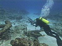
The Algarve Resident
|
|
Five marine archaeologists were among the crew arriving home on the National Oceanic and Atmospheric Administration vessel Hi’ialakai.
They said they were overjoyed by what they found on the ocean floor off Hermes and Pearl atolls.
|
‘I have been diving on shipwrecks for 30 years and this is one of the most exciting trips I have ever taken. It is just outstanding,’ marine archaeologist Dr. John Broadwater said.
Scattered on the ocean floor was the wreckage of the whaling ships Pearl and Hermes. Both vessels were destroyed in a storm of the Pearl and Hermes atolls.”
[Full Story]
“Underwater archaeology expedition in River Arade”
June 9, 2005, The Algarve Resident, Portugal: “PORTIMÃO’S RIO ARADE estuary is the location for an underwater archaeological campaign entitled ‘Missão ProArade 2005’, taking place now until July 31.
Its objective is to conclude the excavation, registry, dismantlement and the total recuperation of the wooden hull of the so called Arade 1 boat that was located in 2001.
|
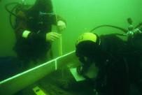
The Algarve Resident
|
|
An agreement between the Instituto Português de Arqueologia (IPA), the Centro Nacional de Arqueologia Náutica e Subaquática (CNANS) and the Portimão Câmara/Museu Municipal de Portimão (MMP) has been signed to support the team’s work.
|
Back in the 1970s, following some dredging of the River Arade, two wooden boats were found and named Arade 1 and Arade 2, which archaeologists believe are the most significant findings from the Portimão river.
The Arade 1 is thought to date back to the first half of the 15th century/first half of the 16th century and is one of the oldest vessels ever to be found in Portuguese waters. For this reason, it is of great importance to Iberian naval archaeology.”
[Full Story]
“Sub Sea Research Team Plans for Excavation of Ancient Shipwreck Sites Discovered Off Haiti’s Coastline”
June 13, 2005, eMediaWire, USA: “Greg Brooks and John Hardy of the Sub Sea Research team have recently made eight ancient shipwreck discoveries off the coast of Haiti and have recently received approval from the Haitian government to recover and conserve the finds. The team is excited to begin excavation and have the opportunity to provide historical artifacts and shipwreck treasure as well as revenue to Haiti.
The sites had been initially assessed for further identification and dating, and the Haitian government has recently approved Brooks’ outline for recovery and conservation of their finds. Representatives of the government of Haiti will be transporting some of the already recovered artifacts to Boston for further identification.
Brooks says excavation of the eight shipwreck sites will start at the end of June. Once the shipwrecks have been recovered, much of the artifacts and treasure will be brought to Maine for conservation and restoration.”
[Full Story]
“Archaeologists Head to Shipwreck”
June 17, 2005, The Scotsman, Scotland: “A team of Bristol University archaeologists are heading for Tortola in the British Virgin Islands this week to survey the shipwreck site of the HMS Nymph, a Royal Navy sloop which sank after a fire in 1783.
The survey will identify and assess the extent of the ship’s remains and will ultimately aid future excavation of the site.
The HMS Nymph was launched at Chatham Dockyard in May 1778 and served King George III’s Navy as a support vessel in both the East and West Indies.”
[Full Story]
“Search on for secret of Greek sea battle”
June 20, 2005, The Guardian, UK: “They were hopelessly outnumbered, but even then the Greeks knew it would be the battle that could change history. The Asian invaders had entered the Aegean. The ‘comeliest of boys’ had been castrated; the throats of the ‘goodliest’ soldiers ripped out.
Mounted on his marble throne, Xerxes, Persia’s formidable warrior king, looked over the bay of Salamis, confident that he was about to enslave Europe. But instead of victory came defeat.
As the Greeks’ triremes trapped the Asian fleet, smashing it with their bronze rams, Xerxes watched incredulously. His soldiers, he said, were fighting like women.
That was 480BC. Nearly 2,500 years later, the quest to better understand the battles that the victorious Greeks would see as a defining point in their history has reached new heights, as experts yesterday began searching for the lost fleets of the campaign in the northern Aegean.”
[Full Story]
“Archaeological wonders are under the sea”
June 24, 2005, IOL, South Africa: “The recent discovery of the remains of a shipwrecked 4th century BC vessel, nicknamed Kythnos I after the Greek island near which it was found, is the latest testimony of the archaeological riches still submerged in Greek waters.
It also demonstrates the technological advances that underwater archaeology has made in this country in recent years.
Greece has no shortage of skilled archaeologists. But when it comes to underwater research, it is only recently that the Greek ministry of culture has begun mixing academic knowledge with hi-tech wizardry.
Collaboration with the national centre for maritime research (Elkethe), and increased state funding from 2000 onwards, have enabled the culture ministry to open a broad – and still potentially untapped – archaeology frontier under the waves.”
[Full Story]
“Wet weather revives crustaceans with prehistoric heritage”
June 29, 2005, Billings Gazette, USA: “Three-eyed, hairy-legged creatures stir in the mud of Red Lake. They’ve crawled the Earth for 220 million years. They eat aggressively, fight and cannibalize. They’ve slept for a decade, and now they’re very, very hungry.
|
Billings Gazette
|
|
Don’t run screaming or hide your children. Put the pitchfork down. They are just the inch-long Triops longicaudatus, otherwise known as the tadpole shrimp. The crustaceans returned to Red Lake after the long Wyoming drought, kicking off a life cycle that predates the dinosaurs.
‘Every time this happens, I get phone calls. People say “There are trilobites in Red Lake!”‘ said Cody High biology teacher Dan White. ‘But they’re not trilobites. They aren’t horseshoe crabs either, but they look like them.’
‘Triops’ hail from the supercontinent of Pangea – Earth’s singular land mass that started separating 237 million years ago.
|
Because tadpole shrimp are eons older than fish, they can’t defend against them. So the tadpole shrimp pop up where fish aren’t – in muddy, alkaline pools that dry up completely.
This trick-called ‘diapause’ – let the tiny triops outlive the dinosaurs. With short life cycles of 20 to 90 days and unbreakable egg cysts that can stay dormant for 25 years, the tadpole shrimp stay in suspended animation until the time is right.”
[Full Story]
“A rich Greek archaeology frontier lying on the seabed”
June 29, 2005, Kathimerini, Greece: “Underwater riches. This photo, released in June 2005 by the Hellenic Center of Marine Research, shows an amphora of the ancient school of Chios and Samos islands dating from between the fifth and fourth centuries BC, detected by sonar in March 2004 off Chios in eastern Greece, at a depth of 67 meters.
|
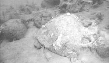
Kathimerini/AFP
|
|
The recent discovery of the remains of a shipwrecked fourth-century BC vessel, nicknamed Kythnos I after the Greek island near which it was found, is the latest example of the archaeological riches still submerged in Greek waters.
|
It also demonstrates the technological advances that underwater archaeology has made in this country in recent years. Greece has no shortage of skilled archaeologists. But when it comes to underwater research, the Ministry of Culture has only recently begun mixing academic knowledge with high-tech wizardry.
Collaboration with the National Center for Maritime Research (ELKETHE) and increased state funding from 2000 onward have enabled the Culture Ministry to open a broad — and still potentially untapped — archaeology frontier under the waves.”
[Full Story]
“UN: Save Underwater Heritage, UNESCO Urges”
June 29, 2005, AKI, Italy: “The UN’s cultural organisation has called on more nations to ratify an international treaty which seeks to preserve the world’s underwater heritage, from sunken cities to historic shipwrecks.
‘Exploration techniques have made the sea bed more accessible than ever, and the pillage of these sites is constantly increasing,’ UNESCO chief Koïchiro Matsuura said.
Welcoming the ratification of the Convention on the Protection of Underwater Cultural Heritage by five countries, he said other must follow suit to enable the treaty to come into force.
‘This is good news for all those who are justifiably concerned by the threats weighing on underwater sites and wrecks, which are poorly protected,’ he added, hoping that the ratifications ‘would encourage other States to follow suit on this Convention which presents a real interest for this particularly vulnerable cultural heritage.’“
[Full Story]
“Pulling the past from river mud”
June 29, 2005, TimesUnion, USA: “FORT EDWARD – Pot shards. A cannon. Bridge remains. And, most tantalizingly, shipwrecks.
The dredging of PCBs from the upper Hudson River won’t just remove 2.65 million cubic yards of mud but will also unearth remnants of the vibrant history of the Fort Edward region, from prehistoric Native American settlements to the French and Indian War and beyond.
‘We can honestly say that Fort Edward is one of the most archaeologically rich communities anywhere in the region, if not the country,’ said David Starbuck, an archaeologist who is advising local authorities. ‘It’s not feasible to collect every artifact, but we have to be worried about Fort Edward losing much of its historical record.’
In hopes they can rescue some of those artifacts before the big dig, due to start in 2007, an intensive archaeological survey is currently using high-tech scanning equipment to see what may lie on the river bottom and its banks.”
[Full Story]
“Underwater heritage convention ratified by five States”
June 29, 2005, UNESCO, France: “Five States (Panama, Bulgaria, Croatia, Spain, Libyan Arab Jamahiriya) have now ratified the Convention on the Protection of Underwater Cultural Heritage, adopted by UNESCO’s General Conference in october 2001.
UNESCO Director-General Koïchiro Matsuura welcomed the ratifications, which he hoped ‘would encourage other States to follow suit on this Convention which presents a real interest for this particularly vulnerable cultural heritage.’
‘This is good news,’ Mr Matsuura added ‘for all those who are justifiably concerned by the threats weighing on underwater sites and wrecks, which are poorly protected. Exploration techniques have made the sea bed more accessible than ever and the pillage of these sites is constantly increasing.’“
[Full Story]
|
|
To understand why this News Page is sometimes late here is some information about Fibromyalgia
if you would like to support our marine archaeology research
The Morien Institute
Research Projects
please send us a book

from our Wish List
“Under Ancient Skies: Ancient Astronomy and Terrestrial Catastrophism”
Paul Dunbavin

EU English Edition Only
but avialable
worldwide
“In all of the world’s myths and religions we find traditions of a Great Flood. There are stories too of a Golden Age: the antediluvian paradise that it destroyed. Might these be real memories of the ancient world? And how can we analyse the subject scientifically? The key to unlock these ancient myths lies in astronomy. “Under Ancient Skies” will examine the astronomical evidence for an ancient cataclysm and in the process will explore a number of related anomalies in prehistory, including: Was there a single great flood in human prehistory, or have there been many?
Could the workings of ancient calendars and the records of ancient eclipses give us clues about the Flood and the antediluvian world? Did the Celtic Druids use a calendar based on the orbit of Saturn; and is this the same antediluvian calendar as is described in Plato’s myth of Atlantis? Do Hindu, Chinese and Mayan cosmology myths recall the years after the Flood when our world wobbled on its axis?
Geologists have recently found the crater in Yucatan, where an asteroid impact destroyed the world of the dinosaurs. Scientists and astronomers have stopped dismissing the theory that a comet could have struck the Earth during prehistory – but any suggestion that a comet impact just a few thousand years ago might have caused the Biblical Flood, remains the last taboo. It is time for this barrier too to be washed away. If you read this book and you understand it then be warned – it may scare you!”
…
exclusive
…
October 2002
Morien Institute
illustrated interview with
Professor Masaaki Kimura
of the University of the Ruykyus,
Okinawa, Japan, regarding
the discovery of:
“Megalithic structures found underwater off the coast of
Yonaguni-jima, Japan”
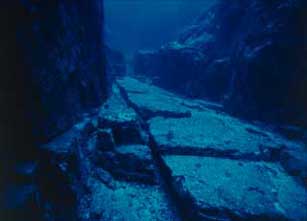
…
exclusive
…
June 2002
Morien Institute
illustrated interview with
Dr Paul Weinzweig
of Advanced Digital Communications,
Havana, Cuba, regarding
the discovery of:
“Megalithic urban ruins discovered off the coast of Cuba”
SeaLife
SL560 ReefMaster PRO
Set 35mm Camera

FEATURES:
Waterproof to 164 feet
35mm wide-angle lens
Triple-element lens construction
Push-button operation
Comes with SeaLife macro 3x close-up lens/underwater filter, SeaLife care kit, and external flash
“Atlantis of the West: The Case For Britain’s Drowned Megalithic Civilization”
by Paul Dunbavin

EU English Edition
“Do Welsh legends of lost cities beneath the sea match Plato’s descriptions of the island civilization of Atlantis? Do Irish myths of a golden age when the eastern Irish Sea was a flowery plain describe the same place Herodotus said disappeared beneath the waves during a single day and night of geological upheaval millennia before Ancient Greece?
Author and researcher Paul Dunbavin has embarked on a multidisciplinary investigation into how science could explain such a catastrophe and how modern archaeological findings point to a possible location for lost Atlantis. This book theorizes that the Middle Neolithic period around 5,000 years ago was a time of dramatic climate and sea-level changes all around the world.
From an up-to-date scientific perspective, Dunbavin distills an array of significant geological theories and then examines the archaeological and mythological record-which together leads to a lost land thousands of years ago in the Irish Sea that was still mentioned in ancient Welsh histories recorded in the 6th century.”
“Eden in the East: The Drowned Continent of Southeast Asia”
by Stephen Oppenheimer

EU English Edition
“A book that completetly changes the established and conventional view of prehistory by relocating the Lost Eden – the world’s 1st civilization – to SouthEast Asia. At the end of the Ice Age, SouthEast Asia formed a continent twice the size of India, which included Indochina, Malaysia, Indonesia and Borneo.
The South China Sea, the Gulf of Thailand and the Java sea, which were all dry, formed the connecting parts of the continent. Geologically, this half sunken continent is the Shunda shelf or Sundaland.
He produces evidence from ethnography, archaeology, oceanography, from creation stories, myths and sagas and from linguistics and DNA analysis, to argue that this founder civilization was destroyed by a catastrophic flood, caused by a rapid rise in the sea level at the end of the last ice age.”
“Discovery of Atlantis: Startling New Evidence and the Case for Cyprus”
by Robert Sarmast

EU English Edition
“Plato provided 53 physical clues in his famous dialogue Critias–the original account of the story of Atlantis that is the sole basis of all Atlantis research.
Discovery of Atlantis proves that the island of Cyprus and the underwater landscape just south of Cyprus is a perfect match with 51 of these clues. Exclusive 3D bathymetric maps based on new scientific data show for the first time a stretch of sunken land off of Cyprus.
The general layout of the landscape of Atlantis as described by Plato is easily discernible on this underwater landmass, as well as the precise location of its capital–Atlantis City. This robust empirical data is joined with other original findings based on mythological analysis and historical research, making the case for Cyprus increasingly obvious.”
“Underworld: The Mysterious Origins of Civilization”
by Graham Hancock
&
Santha Faiia
(Photographer)
EU English Edition
“From Graham Hancock, bestselling author of Fingerprints of the Gods, comes a mesmerizing book that takes us on a captivating underwater voyage to find the ruins of a lost civilization that’s been hidden for thousands of years beneath the world’s oceans.
While Graham Hancock is no stranger to stirring up heated controversy among scientific experts, his books and television documentaries have intrigued millions of people around the world and influenced many to rethink their views about the origins of human civilization. Now he returns with an explosive new work of archaeological detection.
In Underworld, Hancock continues his remarkable quest underwater, where, according to almost a thousand ancient myths from every part of the globe, the ruins of a lost civilization, obliterated in a universal flood, are to be found.”
“Atlantis and Earth’s Shifting Crust”
VHS NTSC version
(USA and Canada)
“Searching for Lost Worlds: Atlantis”
VHS NTSC version
(USA and Canada)
“Quest for the Lost Civilisation: Boxed Set”
VHS NTSC version
(USA and Canada)
VHS UK PAL version
(UK and Europe)
OCEANMASTER Z4 MASK

“SeaLife ReefMaster DC310 Digital MAXX 3.3MP Digital Dive Camera”
“The Atlantis Blueprint: Unlocking the Ancient Mysteries of a Long-Lost Civilization”
by Colin Wilson & Rand Flem-Ath

EU English Edition
“The Great Pyramid. Stonehenge. Machu Picchu. For centuries, these and other sacred sites have inspired wonder among those who ponder their origins.
Conventional science tells us they were constructed by local peoples working with the primitive tools of a fledgling civilization. Who could have built these elaborate monuments? How did they do it? And what were their incomprehensible efforts and sacrifices designed to accomplish? Now comes a revolutionary theory that connects these mysteries to reveal a hidden global pattern–the ancient work of an advanced civilization whose warnings of planetary cataclysm now reverberate across one hundred millennia.
International bestselling author Colin Wilson and Canadian researcher Rand Flem-Ath join forces to share startling evidence of a fiercely intelligent society dating back as much as 100,000 years–one that sailed the oceans of the world, building monuments to preserve and communicate its remarkable wisdom.”
“Atlantis: Mother
of Empires”
by Robert B.Stacey- Judd

EU English Edition
“Stacy-Judd’s 1939 classic is the best book ever on the subject of Atlantis. Stacy-Judd was a Los Angeles architect who was fascinated by the Maya and their connections to Atlantis.
Long out-of-print, this popular of all Atlantis books is again available. Stacy-Judd’s training as an architect and draftsman put him in a unique position to evaluate and express in drawing his theories and evidence for Atlantis.
This is the book that has the original photo of the famous Mayan frieze of a pyramid being destroyed in a volcanic explosion and people escaping in a boat. Packed with Stacy-Judd’s photos and illustrations, this book belongs in every Atlantis library!”
“The Round Towers
of Atlantis”
by Henry O’Brien

EU English Edition
“First published in 1834 as “The Round Towers of Ireland” or the “Mysteries of Freemasonry, of Sabaism, and of Budhism”, this book was an instant sensation as one of the first modern studies of Atlantis, round towers, pre-Christian megalithic architecture and secret societies.
In addition to being a sourcebook on Atlantis Research, Druidic Culture and origins of modern Celtic Christianity, the book is a treasure-trove of ancient esoteric lore and arcane knowledge of the past, including:
The History of the Tuath-de-Danaans, The Round Towers and Megalithic Crosses of Ireland are pre-Christian, Ireland’s strange connections with ancient India, Persia and China, Ancient Secret Societies and Ireland, Ancient Egyptians and Ireland, Pre-Christian Messiahs, Mithraism, and Ireland, The Connections Between Atlantis and Ireland.”
“Submerged: Adventures
of America’s Most Elite Underwater Archeology Team”
by Daniel F. Lenihan

EU English Edition
“One of the world’s leading underwater archeologists recounts experiences from his 24 years as founder and head of the elite, award-winning Submerged Cultural Resources Unit (SCRU) team of the U.S. National Park Service-adventure writing at its best.
In Submerged, Lenihan (the co-author with Gene Hackman of the novel Wake of the Perdido Star) takes the reader on a kaleidoscope of underwater experiences-to ancient ruins covered by reservoirs in the desert southwest, to the lower rings of hell to retrieve the bodies of drowned divers, to gripping accounts of personal survival in underwater caves, ships, and submerged buildings. Among the astonishing, often harrowing assignments he recalls:
• The Isle Royale shipwrecks: Surveying ten large ships sunk from the mid-19th to mid-20th centuries in the middle of the frigid and deep Lake Superior. • The USS Arizona in Pearl Harbor: Executing the largest mapping project ever conducted underwater, and his personal impressions as, the leader of the first expedition to explore and video the entire ship in 1983.”
“Basic Decompression Theory and Application, Second Edition”
by Bruce R. Wienke

EU English Edition
“The new 2nd Edition of Basic Decompression Theory And Application has been extended, updated, with new material added. It takes all rudiments of decompression theory and phase mechanics to considerable depth, while focusing on diving applications in an historical perspective.
Topics span many disciplines, and the targeted audience is the commercial diver, hyperbaric scientist, doctor, physical scientist, technical diver, and instructor. Recent developments in diving tables, decompression meters, and decompression management software are presented, and broad model underpinnings are detailed and contrasted.
Testing and validation of modern dual phase approaches to staging for decompression, extended range, altitude, and mixed gas diving are a focus of discussion. Deep stops, optimal gas switches, and helium mixes are underscored from diver experience, data, and coarse grain principles. References and numerical examples (with solutions) are included for more detail and extended diver analysis.”
“Successful Underwater Photography”
by Brian Skerry & Howard Hall
EU English Edition
“From fundamental principles of photographing marine life to making a living selling underwater photographs, Successful Underwater Photography provides an unlimited wealth of practical advice, surefire strategies, and tested tips for taking extraordinary photos of elusive underwater subjects.
Written by two top photographers who specialize in marine photography, this solid, lavishly illustrated field guide provides no-nonsense information on such topics as taking available-light photographs, silhouettes, marine wildlife portraits, close-focus wide angle photographs, and extension tube photographs to name just a few. Readers will also find proven guidance for purchasing underwater photographic equipment, taking photos of shipwrecks, and repairing and maintaining field equipment.
Plus, 150 stunning, full-color photos demonstrate the authors’ successful techniques in action. For all aspiring underwater photographers who want to unlock the secrets of how top names in the field achieve spectacular results, Successful Underwater Photography is your definitive one-stop guide.”
“Digital Imaging for the Underwater Photographer”
by Jack Drafhal & Sue Drafhal
EU English Edition
“How to Solve Common Problems, Repair Images and Create Dazzling Presentations; Focusing on the aspects of digital imaging that are most important to underwater photographers, this book is a step-by-step guide for the professional and amateur alike to improve their images and presentations. Designed to help the underwater photographer make a smooth transition to digital imaging, this book discusses how to digitally refine, correct, and enhance underwater photographs. Detailing the equipment necessary, it also includes a discussion on the essentials of scanning. There is also extensive information on Adobe Photoshop, and how it can be used to edit underwater pictures.
Designed to help the underwater photographer make a smooth transition to digital imaging, this book discusses how to digitally refine, correct, and enhance underwater photographs. Detailing the equipment necessary, it also includes a discussion on the essentials of scanning. There is also extensive information on Adobe Photoshop, and how it can be used to edit underwater pictures.
Designed to help the underwater photographer make a smooth transition to digital imaging, this book discusses how to digitally refine, correct, and enhance underwater photographs. It details the equipment necessary for digital imaging for underwater photography, and includes a discussion on the essentials of scanning. There is extensive information on Adobe Photoshop, and how it can be used to edit underwater pictures. This book also investigates the ethics of photo manipulation and discusses the future of underwater photography.”
“When the Sky Fell:
In Search of Atlantis”
by Rose & Rand Flem-Ath
EU English Edition
“Did Atlantis really exsist? If so,where was it,and what happened to it?
Inspired by the theory that at various stages in prehistory the earths crust shifted dramatically,causing violent earthquakes, tidal waves,devastating climatic changes,the authors examine the clues as to the location of Atlantis entrusted to Plato by Egyptian priests,the extraordinary similarities between myths from around the world,and ancient and amazingly accurate maps of South America and ice free Antarctica that date long before the first European explorers ever reached those shores.
They conclude that a civilization of highly intelligent seafarers did exists some twelve thousand years ago, but was destroy ed,by a geological disaster,leaving only a few survivors to safeguard its relicsand legends for posterity.”
“Atlantis, the Antediluvian World”
by Ignatius Donnelly
EU English Edition
“The most important book of its time (1882) on the subject of Atlantis.
The author claims there once existed in the Atlantic Ocean, opposite the mouth of the Mediterranean Sea, a large island, which was the remnant of an Atlantic continent, and known to the ancient world as Atlantis, that Atlantis was the region where man first rose from a state of barbarism to civilization, that the gods and goddesses of the ancient Greeks, the Phoenicians, the Hindus, and the Scandinavians were simply the kings, queens, and heroes of Atlantis, that the mythologies of Egypt and Peru represented the original religion of Atlantis, which was sun-worship, etc., etc. Illustrated with photographs.”
“The Round Towers
of Atlantis”
by Henry O’Brien
EU English Edition
“First published in 1834 as “The Round Towers of Ireland” or the “Mysteries of Freemasonry, of Sabaism, and of Budhism”, this book was an instant sensation as one of the first modern studies of Atlantis, round towers, pre-Christian megalithic architecture and secret societies.
In addition to being a sourcebook on Atlantis Research, Druidic Culture and origins of modern Celtic Christianity, the book is a treasure-trove of ancient esoteric lore and arcane knowledge of the past, including:
The History of the Tuath-de-Danaans, The Round Towers and Megalithic Crosses of Ireland are pre-Christian, Ireland’s strange connections with ancient India, Persia and China, Ancient Secret Societies and Ireland, Ancient Egyptians and Ireland, Pre-Christian Messiahs, Mithraism, and Ireland, The Connections Between Atlantis and Ireland.”
|