|
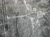
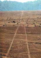
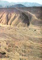
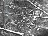
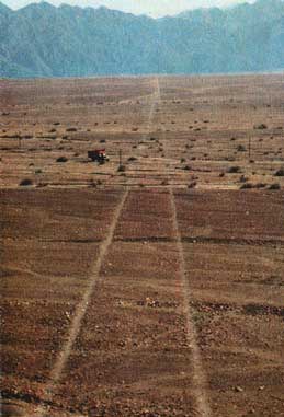
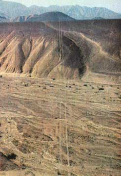
The aerial photographs below show exactly how straight these lines really are. It is believed they were drawn into the landscape in approx. 600 BC, though how they were built so accurately is still a mystery. They go on for many miles over mountains, across deep ravines and gorges and up and down valleys.
The skills of the surveyors who directed the amazing construction of the many straight lines on the Nazca Plain must be acknowledged and also admired for this great achievement.
Maria Reiche writes of the moment Dr. Paul Kosok, the man who first brought her attention to them, discovered the astronomical orientation of one of the straight lines.
Copyright © 1949, Maria Reiche
“There can be no doubt that with this enormous amount of work, continuing through hundreds of years, ancient Peruvians pursued a definate aim, which lay in the centre of their interest.
Dr. Paul Kosok, who was the first to tell about the drawings, was also the first to suggest a plausible explanation.
A chance observation which he made on the same day he discovered the first figure, led him to it.
After recovering from the wonder of seeing on his tracing-paper the figure of a bird, which had taken shape gradually as he was surveying the winding paths he saw before him, he left, and on his way back found himself at a place with many lines radiating from it.
At that moment the sun set in the direction of one of these lines. It was June 21st, the solstice day, in the northern temperate zone the longest day of the year.
If this line was constructed specifically for a solstice observation, then at least the meaning of one was explained.
Perhaps all the lines were constructed towards horizon-points where heavenly bodies set and rose, and the drawings were, as Dr Kosok named them:
‘the largest astronomy book in the world’
These straight lines go on for many miles across mountains and plains alike in the Nazca region of Peru.
There are also similar lines seen from the air in Bolivia, where they are known as ‘ceque lines’.
As with the other geometric shapes and animal figures there is much speculation as to their original purpose, but an astronomical explanation is the most favoured.
It is not known at present if similar lines exist in any of the other South American countries.
Copyright © 1949, Maria Reiche
“The first step towards proving this was a search for more solstice-lines. It can be no chance-happening that of each of the three longest oscillating lines the first piece points in a solstice direction.
People in the temperate zones of the northern hemisphere from December 21st on begin to look forward to the arrival of Spring bringing new life to the frozen earth. They watch the sun attaining higher positions, rising earlier and setting later.
December is also a month of expectation in Nazca. People watch eagerly the dry riverbeds which are due to fill with water, which can be conducted over the fields to cover again the dry, barren lands with luscious green.
The sun’s rising and setting points, oscillating like a pendulum over east and west, could be employed as a giant time-measuring device on which to read the return of the fruitful season and the intermediate epochs.
All over the world monuments can be found which were built for the observation of the solstices. The best known in Europe is Stonehenge in southern Britain. It consists of giant stone pillars which were arranged along sun and moon directions. Similar monuments exist in Peru and Bolivia.”
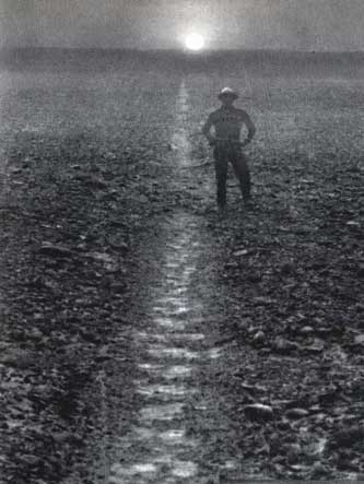
The photograph below is of the midwinter solstice sun setting just to the right of one of the lines on the Nazca plain.
The midwinter sun set ‘exactly’ over this line between the 6th. and 1st. centuries BC, and if it was constructed for that purpose then it quite probably dates from that period.
In common with most ancient cultures, the peoples of these areas obviously also observed the extreme positions of the sun rising and setting at the equinoxes and solstices – though this is in reverse order in the Southern Hemisphere than the Northern Hemisphere.
Copyright © 1949, Maria Reiche
“The purpose for which they were built could be gathered from their name in the native language.
They are called ‘Intiwatana’, or ‘the place to which the sun is tied’, a name that could be derived from the fact that around the solstice dates the directions towards the rising or setting of the sun remain the same, similar to a pendulum which stands still before the reversal of its motion.
The moon directions refer to a movement of its rising and setting points, which, like those of the sun, oscillate over east and west. Only here the shifting back and forth does not extend over a year, but takes only about a month, its amplitude being in some years more, in others less, changing within a cycle of about 18 years.
In a similar way as the moon directions found at Stonehenge, the numerous lines in Nazca pointing in the corresponding directions, could have been constructed as indicators of extreme positions of moonsets and rises on both sides of the east-west direction.
Especially within these tropical latitudes, where sun and moon, when at their highest point in the sky, alternate between northern and southern positions, this change cannot have remained unnoticed.”
It is remarkable that Maria Reiche and Dr. Paul Kosok were able to discern so much astronomical data at this early time.
The opposition from mainstream archaeologists to any astronomical interpretation of ancient sites was at its most apoplectic during their times at Nazca, and the same ridiculous nonsense continues to this day unabated amongst some so-called “experts” in academia.
all quotes on these tribute pages are from
“Mystery on the Desert”
by Maria Reiche
if you would like to support our
astro-archaeology research projects
please send us a book

from our Wish List
|

