Underwater Discoveries – News Archive 2000

The Morien Institute - skywatching through the ages

text translation service for many worldwide languages


Over the past decade or so there have been numerous discoveries about the ancient world, many of which cannot be explained by the traditional views of prehistory as interpreted by mainstream archæologists. It would be impossible to keep abreast of them all, but many have major implications for our greater understanding of the cataclysmic events of antiquity which are remembered in the stories of Atlantis, the Deucalian flood, and the flood of Noah that have been passed down from generation to generation in both oral and written traditions since time immemorial

Of course, there are so many ancient tales of flooded kingdoms, cataclysmic inundations and sunken lands from more or less every corner of the world, that it is difficult to avoid the basic question of whether or not they all refer to the same cataclysm, or a series of cataclysms that happened over several millennia from around 15,000 BC to around 1,500 BC? Many scientists now believe that there were a series of rapid sea-level changes which marked the abrupt end of the last Ice Age, especially at the time of Plato’s original date of 9,600 BC where he placed the supposed destruction of Atlantis.

The melting ice-sheets, it is believed by ‘uniformitarians’, were sufficient to account for these sea-level rises, but other scientists are looking at the possibility that supermassive quantities of water-ice were rudely delivered to the Earth by a giant comet which passed close to the Earth and the Moon at the end of the Pleistocene era – again at around 11,500 years ago. This ‘event’ was coeval with the world’s major mountain ranges – such as the Alps, the Andes, and the Himalayas – attaining their present elevations, whilst many of the world’s low-lying basin areas collapsed in an abrupt series of crustal deformations caused by the gravitational effects of a celestial body in such close proximity to Earth.

Many of the world’s ‘deluge traditions’ refer to a celestial agency as having been the cause of the global floods, as well as the major rifting of Earth’s crust in numerous locations, and possibly also causing a tilt in the Earth’s rotational axis which brought about the seasons and the frigid polar regions as we now know them. The mass extinctions which marked the end of the Pleistocene and the start of the present Holocene era are also dated to between 10,000 and 12,000 years ago, as are the unconsolidated jumbles of now extinct land animals, marine lifeforms, and Pleistocene flora which comprise the many types of ‘drift deposits’ found jammed with extreme force into caves and rock fissures worldwide.

Many species from widely differing climatic zones and habitats lie side-by-side in bits and pieces evidencing the violent nature of their common demise, and careful analysis of these suggest the cause as being not the Ice Age of the uniformitarians, but the tumultuous swirling waters of mega-tsunami. Either way, the major question which cannot any longer be reasonably avoided by serious prehistorical researchers must be:

“What more evidence of ancient civilisations, and of the sea-faring peoples of world-wide

mythology, remains to be discovered beneath the waves on the

continental shelves all around our planet?”

more underwater discoveries


Marine Archaeology News 2015 |
Astro-Archaeology News 2015

Tsunami Past & Present

Terrestrial Archæology & Solar System History

News Headlines Archive

updated daily


Bookmark this page

 Today is

Saturday, February 25, 2023 

Send this page to a friend

“The Atlantis Blueprint: unlocking the mystery

of a long lost civilization?”

October 26 2000 – Over the past five years, and since the publication of

“When The Sky Fell”, Rand Flem-Ath has been working with the renowned author, Colin Wilson, who wrote the introduction to

“When The Sky Fell”, on the many questions raised during the Flem-Ath’s initial research. Published in the UK on October 26th. 2000, their new book, “The Atlantis Blueprint: Unlocking the Mystery of a Long Lost Civilization”, explores the incredible achievements of ancient peoples who accurately surveyed the whole Earth many, many, thousands of years ago. Their abilities are evident in the many ancient units of measurement that are themselves perfect sub-divisions of the Earth’s dimensions. Despite the global trend towards ‘metrication’ many of these ancient units of measurement are still in use today, and a glimpse of the archaic origins of some Greek units of measurement is given in a synopsis of the book that was released prior to publication :

“The most important Greek measurement is called the stade, which is the length of a stadium. The ancient Greeks did not know the size of the Earth, or even that the Earth was round. (A man called Eratosthenes first demonstrated it around 200 BC). Yet the equator is exactly 216,000 stade long. If you divide that by 360, then get it into degrees, it works out at 600. Divide that again by 60 to get it into minutes of a degree, and it works out at 10. Divide that by 60, to get it into seconds of a degree, and you get 100 Greek feet.

Those precise figures cannot be a coincidence. The Greeks may not have known the size of the Earth, but somebody did. Who? Who did the Greeks inherit it from? The obvious suspects are – one might suppose – the Sumerians. After all, it was they who divided the hour into 60 minutes, the minute into 60 seconds, etc. The trouble is – the Sumerians, like the Greeks, had no possible way of knowing the size of the Earth. They didn’t even sail the globe. The conclusion Rand Flem-Ath and Colin Wilson reach again and again is that this knowledge dates back many thousands – and tens of thousands – of years, to ancestors who lived an unthinkably remote time ago.”

Many ancient units of measurement relate to each other in schemes of regular geometry that have become evident in numerous studies of prehistoric monuments located as far apart as Stonehenge and the Great Pyramid of Giza, and which are also found in the regular geometric distribution of various ancient megalithic monuments around the globe. That ancient peoples the world over were aware of, and regularly used, these schemes of geometry in the siting and dimensions of their various monuments is now well beyond dispute, as is the fact that they were aware of the dimensions of both the Sun and the Moon as well as the Earth.

The mean diameter of the Moon, given by John Michell in his pioneering work, “The New View Over Atlantis”, as 2160 miles, and that of the Earth as 7920 miles, indicate that these units of measurement of the ancient Britons were known and used universally in prehistoric times as part of an ancient ‘canon of harmony and proportion’ that is today long forgotten, despite many of the units themselves still being in popular use. The numbers, 216 and 792, appear time and again in the dimensions of ancient megalithic monuments in various parts of the world – monuments which were built in local units of measurement that are geometrically related to each other within this ancient ‘canon of measures’, and at the centre of which lies the ‘sacred geometry’ of the Golden Section.

But more significantly than this even, if that were possible, there are anomalies in the orientation of many of the monuments themsleves that intrigued Rand Flem-Ath, and which seems to have defined the focus of his most recent work with Colin Wilson. In Mexico, at Teotihuacan, they found a pattern of mis-alignment to the cardinal points that was consistently repeated in other monuments around the world. In the Middle East, at the ancient cities of Ur, Nippur and Uruk, they found that temples and ziggurats were orientated slightly west of north, while others further west in Mesoamerica were orientated slightly east of north. On top of this they found that the current physical locations of the Great Pyramid at Giza, and the Tibetan capitol and religious centre, Lhasa, had both proved to have ‘shifted to latitudes further north’ in a manner complimentary to the apparent mis-alignments of various ancient megalithic monuments they had studied in many places around the world.

In the course of their research, Rand Flem-Ath and Colin Wilson discovered that many of these anomalies pointed consistently to various monuments having been orientated towards the Old North Pole at the locations it had occupied prior to the last great Earth-crust displacement around 9,600 BC. Before this cataclysm, the North Pole, according to Rand Flem-Ath and Colin Wilson, was located in the Hudson’s Bay area of North America at 60N 83W, and prior to that in the Yukon region of Canada. The massive earth-crust displacements required for this to have happened was first proposed by the late Charles Hapgood, whose book “The Path of the Pole”, would make an excellent companion to

“The Atlantis Blueprint” , as would Giogio de Santillana and Hertha von Dechend’s classic essay on myth and the frame of time,

“Hamlet’s Mill” – an excellent pioneering study that delves deeply into the wealth of astro-mythologies of polar-shift found in many ancient cultures.

Sound scientific evidence of the most primitive living conditions endured by the survivors of the 9,600 BC cataclysm is accompanied by similar geophysical and archæological evidence of this latest earth-crust displacement that the authors believe destroyed the Atlantean cultures – the remnants of whose monuments and sacred centres Rand Flem-Ath and Colin Wilson have studied to produce

“The Atlantis Blueprint”. The prehistoric units of measurement that are evident not only in the monuments themselves, but also in their global distribution, combined with their geodetically numerical significance, and geometric relationship to other units of measurement in the ancient ‘canon of measures’, suggest a common source that is without doubt of very great antiquity. Hapgood felt that advanced civilisation could have been well established on a global basis as long as 100,000 years ago, which in the light of the discovery of the Schoningen spears is nowhere near as outrageous as it may at first seem.

Have Rand Flem-Ath and Colin Wilson lifted the veil of secrecy around this ancient ‘canon of measures’ further than previous researchers? The ‘Table of Contents’ for the new book posted on the Flem-Ath’s website gives some clear hints that they may well have done just that. “Chapter Eight: Golden Section Sites” covers many of the ‘sacred geometry’ mysteries that have intrigued the enquiring minds of elite members of numerous secret societies for centuries – organisations which have claimed to be the ‘keepers of sacred knowledge’.

From their investigations of the large-scale landscape geometry of the Rennes-le-Chateau area, the 12th century AD Knights Templar exacavations at King Solomon’s Temple in Jerusalem, through Freemasonry and the Priory of Sion, to the enigmatic underwater monument at Yonaguni, Rand Flem-Ath and Colin Wilson have unearthed a ‘blueprint’ that they are conviced ‘fits’ the pattern of global distribution and orientations of many ancient structures. Can they push the origins of human civilisation back tens of thousands of years earlier than any time previously thought possible? Have their efforts uncovered the existence of a global geodetic survey of our planet that was conducted many thousands of years ago, well before the end of the last Ice Age?

Destined to shake the foundations of the standard interpretation of prehistory,

“The Atlantis Blueprint” is a welcome addition to the growing body of serious literature about ancient civilisation that has emerged in recent decades. The reaction to it’s publication, not just from archæologists but from scholars of the historical sciences generally, has been prominent by its absence so far. It has all the potential to raise the level of debate about prehistoric civilisation to a stage that might finally incorporate discussion of the many and varied archæological anomalies that numerous unimaginative academics have previously chosen to ignore. You can read our review of “The Atlantis Blueprint” by clicking here.


“Archaeologists probe legendary city”

BBC News Online, UK – October 19, 2000

an image/link directly to the BBC story

Copyright © October 19 2000

BBC News Online

“Archaeologists have uncovered what they believe to be the remains of a long-lost ancient Greek city, Helike.

Classical texts suggest that all its inhabitants perished when the city sank beneath the waves after suffering a disastrous combination of earthquake and tidal wave.

Some scholars have speculated that the catastrophe may well have been the source of Plato’s story of Atlantis, a land that supposedly suffered a similar fate.

In the centuries following the disaster, several classical writers, including Pausanias and Ovid, reported that the ruins of Helike could still be seen below the waves from the surface.”

[full story]


“Egypt opens up marine treasures”

BBC News Online, UK – September 24, 2000

“Officials in Egypt say they have agreed to allow tourists to visit newly discovered underwater archaeological sites in Alexandria.

The head of the city’s Marine Archaeology Department, Ibrahim Darwish, told the BBC the decision was part of wider efforts to attract visitors to Alexandria.

Over the past few years archaeologists working the seas off Alexandria have begun to reveal the lost remains of one of history’s greatest ancient cities – now a crowded modern town”

[Full Story]


Human habitation found under Black Sea

latest developments

September 19 2000 – National Geographic.com announced that the Turkish Minister of Culture, Istemihan Talay, has granted the National Geographic Black Sea expedition a permit to recover artifacts from the sea floor at the location where Dr Ballard and his team have found evidence of ancient human habitation.

[Regretably, we have been unable to find the new link to the National Geographic page dealing with this update since early 2002 – JM]


Bible ‘clue’ found in Black Sea.

September 13 2000BBC News Online has reported that scientists have uncovered ancient ruins under the Black Sea which indicate that people lived in the area before a cataclysmic flood inundated their homeland. Some scientists have linked the 7,000-year-old event, thought to have been caused by waters bursting through from the Mediterranean Sea, to the Biblical story of Noah. Dr Robert Ballard told the BBC that:

an image/link direct to the BBC story

BBC Online

“This is an incredible find …”

adding this was far more significant a find than his discovery of the Titanic way back in 1985.

“It’s clear a vast amount of real estate is under water and a vast amount of people were living [here]. This is a major discovery that will begin to rewrite the history of cultures in this key area between Europe, Asia and the ancient Middle East”.

The team, sponsored by National Geographic, found a rectangular structure, possibly a building, with wooden beam, branches and stone tools lying 90 metres under the sea, of the coast from Sinop. Scientists believe the Black Sea was previously a smaller freshwater lake that was flooded by the Mediterranean Sea 7,000 years ago, when European glaciers melted, the BBC reported. It will be interesting to see what develops here, as rumours about the biblical Ark of the Covenant are rife


Human habitation found under Black Sea

Is it evidence of Noah’s Flood?

September 12 2000 – The New York Times reported that scientists have discovered evidence of human habitation under the Black Sea that they consider to be the first proof that people thrived along an ancient shoreline before being inundated by a great flood thousands of years ago.

Dr Robert D. Ballard, an undersea explorer, whose robotic devices have solved many underwater mysteries (including finding the Titanic), told the New York Times:

“We know that there was a sudden and dramatic change from a freshwater lake to a saltwater sea 7,000 years ago. And we know that as a result of that flood a vast amount of land went underwater.”

They have discovered a number of stone tools, and carved wooden beams on the sea floor that are part of a well-preserved, though collapsed, structure similar to the wattle-and-daub structures common to the Black Sea area. They also discovered shells from an extinct freshwater creature that are all 7,000 years old or older, as well as shells from saltwater shellfish that are only 6,500 years old. Some scholars believe that this inundation, believed to have been caused when the European glaciers melted 7,000 years ago, could well prove to be the origin of the biblical story of ‘Noah’s Flood’, and the source of the Babylonian flood tale in the Epic of Gilgamesh


“Black Sea artefacts are proof of great flood”

Independent Online, South Africa – September 12, 2000

“Artefacts found at the bottom of the Black Sea provide new evidence that humans faced a great flood, perhaps that of the biblical Noah, thousands of years ago, the discoverers say.

Remnants of human habitation were found 900m underwater, about 19,2km off the coast of Turkey, undersea explorer Robert Ballard said on Tuesday.

‘There’s no doubt about it, it’s an exciting discovery,”‘ Ballard said in a telephone interview from his research ship. ‘We realise the broad significance the discovery has and we’re going to do our best to learn more.’

[Full Story]


“Ming bowl survives 400 years under the waves”

Independent Online, South Africa – August 30, 2000

Saipan, Northern Mariana Islands – “An intact, but slightly chipped, fragile Ming Dynasty bowl has been recovered from a 400-year-old shipwreck, archaeologists said here on Wednesday.

It came from the Manila galleon, Santa Margarita, wrecked in March 1601 off Rota Island near here. Of more than 300 people on board, fewer than 50 survived.

The bowl and other artefacts have been shown to members of the Commonwealth of the Northern Mariana Islands (CNMI) Historic Preservation Board, as well as officials from the Museum of History and Culture.”

[Full Story]


“Ancient find in Lake Titicaca pre-dates Incas”

August 24 2000 – It was reported in The Guardian newspaper that an Italian team of scientists have discovered the remains of a temple at the site of a ‘mythical city’. Alex Bellos, their South America correspondent, filed a story that told of the recent discovery of the ruins of a huge temple underwater in Lake Titicaca in the Andes between Bolivia and Peru.

Archaeologists from an international expedition team, Atahuallpa 2000, had made more than 200 dives in the lake, which at 3,800 metres above sea-level is the world’s highest navigable lake. Expedition leader, Lorenzo Epis, told Bellos:

“We’ve found what appears to have been a 200-metre-long, 50-metre-wide holy temple, a terrace for crops, a pre-Incan road and a 700-metre-long containing wall,”

Ceramic artifacts were also found on the floor of Lake Titicaca, which has long been the subject of legends about a ‘lost underwater city’, but Bellos reported that little research had been done before because of the difficulties of diving at high altitudes.

While a submerged city has not been found, Mr Epis said the ruins appeared to be 1,000 to 1,500 years old. It thus predates the Incas and could point to the Tihuanaco people, who lived on Titicaca’s shores before becoming part of the Incan empire.

“This means our civilisations have left more footprints than we had thought,” said Antonio Eguino, Bolivia’s vice-minister of culture. The ruins were found in an area of the lake between the town of Copacabana and the popular tourist destinations of the Island of the Sun and Island of the Moon. The divers followed a submerged road until they arrived at the discoveries, at a depth of about 20 metres.

In addition to the practical difficulties, the research project had to contend with a worried public, who had not been informed of the project. Diving was delayed for four days because of the distrust of the local population on the ‘Island of the Sun’, who believe the lake is sacred.

Akakor Geographical Exploring, an Italian cultural association that organised the expedition, first made a trip to Titicaca in 1998 to look at underwater caves and to research diving techniques at high altitude. Marco Antonio Simi, who was on that expedition, said that the groundwork on pressure levels allowed the group to return this year; most diving technology is based on ocean-bound dives, where pressure levels are very different.

Mr Simi said this was the first time top-level divers and professional archaeologists had investigated Titicaca together, adding that it was rare for specialists of both disciplines to work side by side. The team was looking for an underwater temple. “What they found was the beginning of what they were looking for,” he said.

The story was also carried by BBC Online the previous day on August 23 2000, which also had this interesting underwater picture of divers exploring the recent discovery.

an image/link direct to the BBC story

Copyright © 2001 BBC Online

“Dating back 1,000 to 1,500 years ago, the ruins are pre-Incan.

They have been attributed to the indigenous Tiwanaku or Tiahuanaco people, said Lorenzo Epis, the Italian scientist leading the Atahuallpa 2000 scientific expedition.”

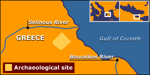
A terrace for crops, a long road and an 800-metre (2,600 feet) long wall was also found under the waters of the lake, sited in the Andes mountains between Bolivia and Peru, the BBC reported:

“The lake has long drawn fascination with various legends around it, including one of an underwater city called Wanaku and another of Inca gold lost by the Spanish. The Incas also regarded the lake as the birthplace of their civilisation, and in their myth, the Children of The Sun emerged out of the waters.”

The complete findings of the 30-member team, backed by the scientific group Akakor Geographical Exploring, are to be published in November 2002.


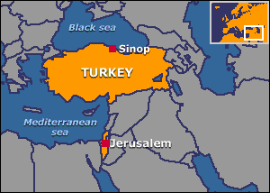
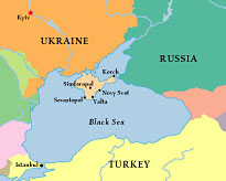
“Interactive Dig: Beneath the Black Sea”

Archaeology Magazine, USA – August, 2000

an image/link directly to the Archaeology Magazine story

Copyright © August 2000

Archaeology

“Privet iz Krime! Greetings from Crimea! Join me as I team up with an expedition of Ukrainian underwater archaeologists in search of shipwrecks along the northern coast of the Black Sea. Our expedition will be diving until mid-August, and I’ll update you on our progress every few days, as well as give you a look into a fascinating region rarely visited by Western tourists.

Feel free to send any questions you may have to [email protected], and I’ll try to answer them in my next posting. Davay! We’re off!”

[full story]


“Giant burp snuffed out ocean species”

Independent Online, South Africa – July 27, 2000

“Huge reservoirs of methane trapped beneath the ocean floor rapidly escaped during prehistoric global warming and depleted much of the sea’s oxygen, according to new research into why many forms of life suddenly vanished 183 million years ago.

The findings, reported in Thursday’s issue of the journal Nature, shed new light not only on the disappearance of as many as 80 percent of some deep-sea species but also a process suspected in other prehistoric mass extinctions.

The study also raised questions about today’s sea floor reservoir of methane hydrate, which the federal government plans to study as a possible energy source.”

[Full Story]


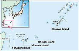
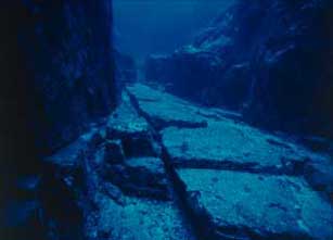
“Is the lost continent of Mu in Okinawa?”

The Japan Times, Japan – July 19, 2000

an image/link directly to The Japan Times story

Copyright © July 2000

The Japan Times

“In the waters off remote Yonaguni Island, from which Taiwan can be seen on a clear day, lies one of Japan’s most puzzling mysteries.

A giant stone structure with perfect geometric angles that appear to be tunnels and staircases has convinced some, including noted writer Graham Hancock, that an unknown ancient civilization occupied the area nearly 10,000 years ago.

But others, including a noted geologist, are skeptical, saying the geometrical shapes of the stones may be due to a unique, but natural, form of erosion.

Recent studies of the phenomenon — such as that by Masaaki Kimura, a professor in the Department of Physics and Earth Sciences at the University of the Ryukyus — have only fueled the debate.”

[full story]


“20,000 Ancient Coins Unearthed from Bottom of Lake”

June 26, 2000, People’s Daily, China: “China has unearthed over 20,000 ancient coins during the dredging of West Lake in the picturesque city of Hangzhou in east China’s Zhejiang Province.

The coins belonged to several dynasties, the earliest dating backing to the Warring States Period (475-221 BCE).

Numismatists and archaeologists from both at home and abroad have shown great interests in these coins, some of which are rare.”

[Full Story]


“Hundreds of sunken monuments, discovered”

June 05, 2000, Arabic News, Egypt: “The European Institute for Sunken Antiquities’ mission working in Abu Qir, Alexandria managed to detect and spot the course of the Nile’s most important branches that sank hundreds of years ago.

The Canubian branch of the Nile, attributed to the ancient port city of Canub, now Abu Qir, had been submerged in the wake of the violent temblor that rocked Alexandria long times ago.

In an international news conference held early Saturday in Alexandria, Franc Godeo, head of the mission, said the Egyptian-French Mission for Sunken Antiquities used satellite survey and detection equipment and depth scanning instruments in spotting the areas where the monuments are perching.”

[Full Story]


“Ancient Greek city discovered under Alexandria waters”

June 03, 2000, Arabic News, Egypt: “The French-Egyptian Archaeological Mission discovered the Greek city of Herculium under Alexandria sea. The Mission, led by French Franc Godeo, found the lost city of Herculium the second Greek city found under the water of Alexandria.

The first was the city of Menotus discovered by Prince Omar Tossun in 1934. Some six ancient Greek cities sank under the waters of the north coast of Egypt when a major earthquake rocked Alexandria in the ancient times.

The discovery ushers in the unraveling of the whole ancient Abu Qir, which used to be known in the past as Canub. Canub was dedicated to the worship of God Osoris and dates back to the Central State, 20 years before Christ. it was called the Graeco-Roman Paris of Egypt.”

[Full Story]


“Divers find Pharaohs’ lost city”

June 03, 2000, BBC News Online, UK: ” Underwater archaeologists working off the Egyptian coast have discovered an entire submerged city dating from ancient times.

At a news conference in Alexandria, the French marine archaeologist, Franck Goddio, revealed the first evidence of what is believed to be the ancient city of Herakleion.

His divers have located a lost world of temples, houses and colossal statues.”

[Full Story]


exclusive

October 2002

Morien Institute

illustrated interview with

Professor Masaaki Kimura

of the University of the Ruykyus,

Okinawa, Japan, regarding

the discovery of:

“Megalithic structures found underwater off the coast of

Yonaguni-jima, Japan”

please left-click to go directly the interview with Professor Masaaki Kimura


exclusive

June 2002

Morien Institute

illustrated interview with

Dr Paul Weinzweig

of Advanced Digital Communications,

Havana, Cuba, regarding

the discovery of:

“Megalithic urban ruins discovered off the coast of Cuba”

please left-click to go directly the interview with Dr Paul Weinzweig


Books about

Underwater Discoveries
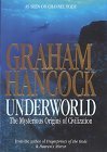
“Underworld”

Graham Hancock

an image/link direct to this product at amazon.com

EU English Edition

“From Graham Hancock, bestselling author of Fingerprints of the Gods, comes a mesmerizing book that takes us on a captivating underwater voyage to find the ruins of a lost civilization that’s been hidden for thousands of years beneath the world’s oceans. While Graham Hancock is no stranger to stirring up heated controversy among scientific experts, his books and television documentaries have intrigued millions of people around the world and influenced many to rethink their views about the origins of human civilization.

Now he returns with an explosive new work of archaeological detection. In Underworld, Hancock continues his remarkable quest underwater, where, according to almost a thousand ancient myths from every part of the globe, the ruins of a lost civilization, obliterated in a universal flood, are to be found.”


“Encyclopedia of Underwater and Maritime Archaeology”

James Delgado (Editor)

an image/link direct to this product at amazon.com

EU English Edition

“This encyclopedia is the first comprehensive reference book on the discovery and recovery of underwater archaeological remains around the world and across time. Written by archaeologists and other scientists who have made the discoveries, it offers a wealth of authoritative and accessible information on shipwrecks, drowned cities, ritual deposits, and other relics of our submerged past.

The volume’s 450 alphabetically arranged entries cover sites from prehistory to the modern era (including Titanic), legislation and legal issues, organizations, nations and regions, research themes, and technology and techniques. Length generally ranges from two paragraphs for reef netting and Southampton Centre for Maritime Archaeology to about four pages for Great Lakes and remote sensing.”


“Cleopatra’s Palace:
In Search of a Legend”

Laura Foreman

an image/link direct to this product at amazon.com

EU English Edition

“In 30 b.c., against the backdrop of Alexandria, Egypt, one of the most majestic of all ancient cities, a great queen proudly and defiantly took her life. More than two thousand years later, the world remains fascinated and haunted by this most intriguing woman, Cleopatra VII, yet practically everything we know about her is based on ancient text fragments, literature, and myth.

Gifted storyteller Laura Foreman brings Cleopatra’s legendary tale to life, from the founding of Alexandria by Alexander the Great, to Cleopatra’s ascent to the Egyptian throne amid treachery and betrayal, to her passionate alliances with Julius Caesar and Mark Antony and her doomed battle against Octavian.

But the legend doesn’t end there. Cleopatra’s Palace also presents the astounding recent findings of world-renowned underwater explorer Franck Goddio, who, with his team of underwater archaeologists, has succeeded in mapping the Royal Quarter of Ancient Alexandria, long submerged beneath the Mediterranean by cataclysmic earthquakes early in the millennium. In a fascinating narrative illustrated by exclusive underwater images, the expedition’s successes are presented, including the discovery of such artifacts as jewelry, statues, sphinxes, rare pottery, and an ancient shipwreck, as well as architectural remains that were found on the site of this magnificent drama.”


“The Sea of Galilee Boat: An Extraordinary 2000-year-old Discovery”

Shelley Wachsmann

an image/link direct to this product at amazon.com

EU English Edition

“This remarkable true story recounts one of the great discoveries of the century: finding a 2000-year-old boat from the Sea of Galilee. Shelley Wachsmann, a respected nautical archaeologist, shares the joy and drama he felt in discovering and excavating the first ancient boat from this biblical location.

The saga of tenderly extracting this extraordinary boat from the earth, protecting its timbers, and restoring it to health is a compelling tale on its own. Wachsmann punctuates the absorbing details of preserving this artifact with the rich history that surrounds the Sea of Galilee, making this a uniquely enduring and personal work.”


“Atlantis of the West:
The Case For Britain’s Drowned
Megalithic Civilization”

Paul Dunbavin

an image/link direct to this product at amazon.com

EU English Edition

“Do Welsh legends of lost cities beneath the sea match Plato’s descriptions of the island civilization of Atlantis? Do Irish myths of a golden age when the eastern Irish Sea was a flowery plain describe the same place Herodotus said disappeared beneath the waves during a single day and night of geological upheaval millennia before Ancient Greece? Author and researcher Paul Dunbavin has embarked on a multidisciplinary investigation into how science could explain such a catastrophe and how modern archaeological findings point to a possible location for lost Atlantis.”

This book theorizes that the Middle Neolithic period around 5,000 years ago was a time of dramatic climate and sea-level changes all around the world. From an up-to-date scientific perspective, Dunbavin distills an array of significant geological theories and then examines the archaeological and mythological record-which together leads to a lost land thousands of years ago in the Irish Sea that was still mentioned in ancient Welsh histories recorded in the 6th century.”


“Atlantis and Earth’s

Shifting Crust”

VHS NTSC version

(USA and Canada)


History’s Mysteries

“Do undersea relics near Okinawa offer proof of a sophisticated civilization during the last ice age? Archeologists have long believed that civilization as we define it — intelligent, tool-making, monument building, social humans — began about 5,000 years ago. But submerged beneath the waves near the Japanese island of Yonaguni is evidence that may well overturn that long-held theory.

A small but persuasive number of scholars and scientists have long thought that “advanced” societies may have existed as long as 10,000 years ago. Their theories, however well reasoned and defended, have been hamstrung by a lack of evidence. But recent discoveries of man-made artifacts on the Pacific seafloor may well prove to be the smoking gun that will propel this alternative view of civilization to prominence”.

see the evidence with ‘unique underwater footage’ of the Yonaguni structures
in the NEW DVD of the

‘History Channel’ television programme

“Japan’s Mysterious Pyramids”

Now On DVD


more underwater discoveries


Marine Archaeology News 2015 |
Astro-Archaeology News 2015

Tsunami Past & Present

Terrestrial Archæology & Solar System History

News Headlines Archive

updated daily


Google


Web

The Morien Institute

please take a look at our Ancient Mysteries Bookshoppe for a wide selection of books

that challenge orthodox views of prehistory on every continent


|
|
|
|


Marine Archaeology News 2015 |
Astro-Archaeology News 2015


all material on this page
The Morien Institute