|
“Raised from the depths … “
June 28, 2008, Dorset Echo, England
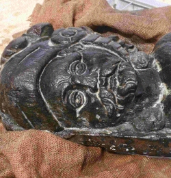
“AN ornate statue rescued from a shipwreck off Poole shows the vessel was once a queen of the seas. The wooden Merman graced the back of a boat lost half a mile from the harbour in about 1620.
MERMAN: Detail of the bearded head of the sculpture
Dorset Echo, England
And the find by Bournemouth University staff and students shows it was no ordinary vessel. David Parham, 43, a marine archaeology lecturer in charge of the project, said: ‘These carvings show someone was making a statement with this ship.’
The merman, which is around 1.4m tall and weights up to 40 kilos, was recovered earlier this month.
It has empty eye sockets that could have been decorated with precious stones, and a northern European style face.”
[Full Story]
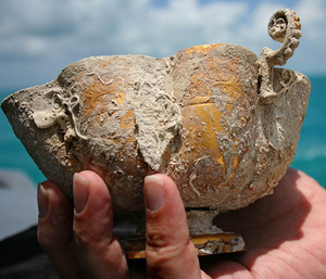
“Ancient gold chalice recovered off Key West”
June 27, 2008, Easier Travel, UK
“Experts began studying and conserving a gold chalice Wednesday, believed to be more than 385 years old, that was recovered Tuesday from Key West waters during the search for a 17th-century shipwrecked Spanish galleon.
Easier Travel, UK
The ornate two-handled chalice is adorned with etched scrollwork on the upper portion, and salvors estimated its value at one million dollars or more.
The chalice was located by Blue Water Ventures diver Michael DeMar beneath about a foot of sand in 18 feet of water approximately 30 miles west of Key West. It was the 20-year-old DeMar’s first treasure find.
The divers were searching the shipwreck trail of the Spanish galleon Santa Margarita. Dan Porter, captain of Blue Water’s salvage vessel, said the chalice was most likely owned by one of the Margarita’s wealthy passengers and may have been a communion cup.”
[Full Story]
“Divers to Search for Lost Sarcophagus”
June 23, 2008, DiveMaster News, UK
“It has been a source of enduring fascination for archaeologists and amateur Egyptologists everywhere: what exactly happened to the sarcophagus of Menkaure, one of Egypt’s greatest Pharaohs? Now, more than 170 years after it was found and lost, the mystery could be solved.
Built from polished blue basalt to transport the king’s earthly remains to the next world, the elaborately decorated vessel lay hidden inside the third-largest of Giza’s renowned Pyramids for more than 4,000 years.
In 1837 the British colonel Richard William Howard Vyse blasted his way into Menkaure’s sepulchral chamber using gunpowder and discovered the stone casket.
The mummy was missing by that time — ancient Arabic graffiti indicated that the colonel was not the first to find the chamber — and he realised that his discovery could open the way for a new generation of grave robbers. ‘As the sarcophagus would have been destroyed had it remained in the Pyramid’, he noted in his diaries, ‘I resolved to send it to the British Museum.’
In a twist worthy of an Indiana Jones film, the sarcophagus was lost again the following year before it could reach British shores. The merchant ship Beatrice, which was carrying it and other antiquities found by the archaeologist, sank while sailing from Malta to Gibraltar — reportedly off the coast of Spain, near Alicante.
Now the Egyptian Government wants to recover it with the aid of underwater robots. Zahi Hawass, who heads Egypt’s Supreme Council for Antiquities, told Spanish journalists that he was seeking financing from the National Geographic Society for the search.”
[Full Story]
“Sunken city Kekova in photographs”
June 23, 2008, Turkish Daily News, Turkey
“Located close to the Mediterranean city of Antalya’s Demre district, the Kekova Harbor and sunken city that was once a Lycian trade center, now submerged under water as a result of earthquakes, draws the attention of local and foreign tourists.
Anatolia Agency photojournalist Cem Özdel, accompanied by museum official I.lknur Erdogan and divers Erkan Çaglar and Cem Gazivekili, photographed Kekova
Turkish Daily News
In this region where swimming is forbidden but diving is allowed with special permission, the photos revealed that most of the historical buildings underwater have been ruined and some have been covered by sea sand because of currents.
In addition, 30 meters from Kekova Island’s coast and 20 meters under the surface, hundreds of amphoras have been broken by treasure hunters.
Photos showed that staircases from Kekova Island to the sea still exist. The breakwaters belonging to two harbors on the north of the island have not collapsed yet, but it was discovered that they are surrounded by waste thrown from vessels.”
[Full Story]
“Mapping Britain’s Atlantis”
June 22, 2008, The Sunday Times, South Africa
“As a great port on the East of England, Dunwich was nothing short of a medieval metropolis. Eight churches, 80 ships, five religious orders — including the Benedictines, Dominicans and Franciscans — and prosperity from its trade in wool, grain, fish and furs to rival London. Such was the city’s prestige that, under Edward I, it was granted two seats in parliament.
Buried treasure: Dunwich legend has it that one can hear
church bells coming from beneath the waves
Brian Harris/Rex Features
But that was before Dunwich was swallowed by the sea. This month , more than five centuries after the last of a succession of storms and sea surges battered the Suffolk city into little more than a village, a research team set sail to discover the secrets of a British Atlantis.
Using the latest acoustic imaging technology — designed to penetrate the high silt levels that have reduced visibility in the water at the site, 1.6km off the coast, to centimetr es — the researchers hope to reveal Dunwich in its prime.
For Stuart Bacon, a marine archaeologist who has spent 30 years studying how Dunwich disappeared, this is a momentous time. He has explored the site by touch, using a map from 1587, on more than a thousand dives, but with limited success.
Now with a team from the University of Southampton, led by Professor David Sear, he hopes to locate and catalogue 16 large structures dating back to the 14th century, including at least two churches, a monastery and a palace. Sear said the team hoped to identify structures that could be correlated with ancient maps and documents.
‘We will be scanning the sea floor, going up and down in grids’, Sear said. ‘We know from maps and documents that many structures existed, but we don’t know where they were, and this will solve that.’“
[Full Story]
“Web Site Following Archaeologists to the Bottom of
Mut Temple’s Sacred Lake”
June 18, 2008, NewsWise, USA
“Follow along online as Johns Hopkins University Egyptologist Betsy Bryan and her team of graduate students, artists, conservators and photographers expand their investigation of Mut Temple this summer, turning their attention to the temple’s Sacred Lake.
Bryan and her crew are once again in Luxor, Egypt, sharing their work via ‘Hopkins in Egypt Today’, their popular digital diary offering a virtual window into day-to-day life on an archaeological dig.
With new posts appearing daily through mid-July, visitors to ‘Hopkins in Egypt Today’ at http://www.jhu.edu/egypttoday/ will find photos of Bryan and her colleagues working on site in Luxor.
In collaboration with the American Research Center in Egypt, which also supports Johns Hopkins’ work inside the temple proper, Bryan will excavate on the northeast arm of the lake after ARCE’s engineers have drained the lake.
Excavation will proceed from the region of an ancient stone dock in a swath around 20 meters in breadth down into the basin of the drained lake. Any materials found in the lake bed will be conserved and desalinated near the bank of the lake before being transferred to a protected environment.
The primary goal of this brief dig is to develop procedures for more extensive excavation of the lake next year.”
[Full Story]
“What are the mysterious stones emerging
from Kinneret waters?”
June 17, 2008, Ha’aretz, Israel
“A marine scientist has discovered a series of mysterious stone patterns on the lake bed of drought-stricken Lake Kinneret.
The man-made piles of stone, which are now above water, jut out from the freshwater lake, and sit 30 meters from each other along a 3.5-kilometer stretch of the eastern shore, from the Kinneret College campus to Haon resort.
Gal Itzhaki of Kibbutz Afikim first noticed the stones while strolling along the lake’s receded shoreline. He says the patterns are a ‘fascinating phenomenon’ and are part of an ‘impressive building enterprise.’
Though they have not yet been scientifically examined, there are several hypotheses as to what functions they fulfilled. One theory postulates that they were part of a boundary between the ancient lakeside towns of Hippos, also known as Sussita, and Gadara.
Both towns were part of the Decapolis, a group of 10 towns that flourished in the eastern part of the Roman province of Palestina, and are mentioned in the New Testament.”
[Full Story]
“Titanic discoverer Robert Ballard called
to find lost sarcophagus”
June 14, 2008, The Times, UK:
“It has been a source of enduring fascination for archaeologists and amateur Egyptologists everywhere: what exactly happened to the sarcophagus of Menkaure, one of Egypt’s greatest Pharaohs? Now, more than 170 years after it was found and lost, the mystery could be solved.
Built from polished blue basalt to transport the king’s earthly remains to the next world, the elaborately decorated vessel lay hidden inside the third-largest of Giza’s renowned Pyramids for more than 4,000 years. In 1837 the British colonel Richard William Howard Vyse blasted his way into Menkaure’s sepulchral chamber using gunpowder and discovered the stone casket.
Franck Goddio discovered artefacts submerged in Alexandria
and is also favoured in the search for the Beatrice
The Times, UK
The mummy was missing by that time — ancient Arabic graffiti indicated that the colonel was not the first to find the chamber — and he realised that his discovery could open the way for a new generation of grave robbers.
‘As the sarcophagus would have been destroyed had it remained in the Pyramid’, he noted in his diaries, ‘I resolved to send it to the British Museum.’
In a twist worthy of an Indiana Jones film, the sarcophagus was lost again the following year before it could reach British shores.
The merchant ship Beatrice, which was carrying it and other antiquities found by the archaeologist, sank while sailing from Malta to Gibraltar — reportedly off the coast of Spain, near Alicante.
Now the Egyptian Government wants to recover it with the aid of underwater robots. Zahi Hawass, who heads Egypt’s Supreme Council for Antiquities, told Spanish journalists that he was seeking financing from the National Geographic Society for the search.”
[Full Story]
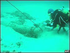
“Maritime ‘treasure trove’ raised”
June 13, 2008, BBC Science News, UK:
“A treasure trove of artefacts is being recovered from what experts describe as one of the most important maritime discoveries since the Mary Rose. The late 16th Century shipwreck hails from a pivotal point in England’s military history.
The raised haul includes a 2m-long (7ft) cannon, which will give archaeologists an insight into Elizabeth I’s naval might. The wreck, discovered 30 years ago, is situated off the coast of Alderney.
Diving to recover the artefacts is dangerous
BBC/Alderney Maritime Trust
Dr Mensun Bound, excavation leader and marine archaeologist from Oxford University, said: ‘This boat is really grade A in terms of archaeology – it is hard to find anything that really compares with it.’
The excavation of the Elizabethan warship is being filmed for the BBC’s Timewatch series.
Recovering the cannon was a delicate operation; divers had to navigate through reef-strewn waters where strong currents prevailed.”
[Full Story]
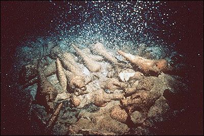
“The 2,000-year-old ‘supertanker'”
June 07, 2008, The Scotsman, Scotland
“Two years ago, a Cypriot diver was stunned by a chance find: hundreds of ancient ceramic wine jars, rising from a featureless expanse of flat, desert-like seabed off Cyprus’s southern coast.
Together they formed the shape of a ghostly ship, still submerged beneath the sands. It now appears that what the diver discovered was a supertanker of its time, and the biggest and probably oldest wreck ever found in the island’s waters.
The merchant vessel may also prove to be one of the best preserved wrecks of the Classical period, from the 5th to 4th centuries BC, archaeologists said yesterday.
‘There are very few shipwrecks of Classical times left, so it will be very important for the study of ancient shipbuilding techniques and navigation’, said Dr Stella Demesticha, a Greek marine archaeologist and visiting lecturer at the University of Cyprus. ‘It will add a lot to our knowledge.’
The ship was carrying high-quality red wine from a Greek island when it sank a mile-and-a-half off the southern coast of Cyprus in about 350BC, around the time Alexander the Great was born. Within days, several of the large wine jars, or amphorae, were brought to the surface.
Why the vessel sank is a mystery – the result of a collision, storm-tossed seas or perhaps structural failure. There is speculation, however, that similar ships were deliberately scuppered to scam the insurers of the day.
The wine was probably destined for one of the island’s renowned ports, Kition or Salamina. Alternately, the ship may have been using Cyprus as a handy stopover on the way to Egypt or the Syrian-Palestinian coast. The island was a well-placed trading hub on the commercial sea routes of antiquity.”
[Full Story]
“Ancient ship was carrying the finest wine”
June 07, 2008, Cyprus Mail, Cyprus
“Archaeologists working on recovering amphorae from the 2,350-year-old Mazotos shipwreck have completed their work for the moment and will resume in October, expedition leader Dr Stella Demesticha said yesterday.
‘We brought up some pieces but I don’t know at the moment if we will bring up more because the expedition has ended for the time being’, Demesticha said. Work was due to resume in October, she added.
Demesticha said six whole amphorae and three partly preserved ones were recovered by divers from the mid-4th century BC commercial ship, which lies at a depth of 45 metres in the area of the village Mazotos, about 2.5 kilometres from the shore.
Over the past few months, a major argument has erupted among researchers over what caused the village and the surrounding region to flood.
The Greek researcher said last week they believe the hull of the ship, which is buried in the sand, is also in good condition but only seawater and sand remain in the amphorae, their cargo long spilled into the sea.
The ship is said to the most important underwater find in Cyprus since the Kyrenia ship was discovered and salvaged in the late sixties. The Mazotos wreck is estimated to be 50 years older than the Kyrenia, which sank in 300 BC.
The expedition to the Mazotos shipwreck is being led by the Research Unit of Archaeology at the University of Cyprus.”
[Full Story]
“Tsunami or melting glaciers: What caused ancient Atlit to sink?”
June 04, 2008, Ha’aretz, Israel
“At the bottom of the sea, some 300 meters west of the Atlit fortress, lies one of the greatest archaeological mysteries of the Mediterranean basin. About 20 years ago, archaeologists discovered a complex of ancient buildings and ancient graves with dozens of skeletons at the underwater site of Atlit-Yam.
The team of marine archaeologists that excavated the site, headed by Dr. Ehud Galili of the Israel Antiquities Authority, came to the consclusion that an ancient settlement once existed there, but sank beneath the surface of the sea some 8,000 years ago.
The finds at the site, including goat and pig bones and wheat seeds, indicate that it was a well-established community whose residents supported themselves by agriculture, hunting, fishing and animal husbandry.
Over the past few months, a major argument has erupted among researchers over what caused the village and the surrounding region to flood.
A few months ago, a team of geologists from Pisa, Italy published a paper that offers a dramatic theory about how the ancient settlement met its end. They claim that the settlement was submerged all at once by a tsunami in the Mediterranean, causing the death of dozens of its inhabitants. This theory attributes the tsunami to something that happened thousands of kilometers away.
About 8,300 years ago, there was a mighty volcanic explosion at Mt. Etna in Sicily. The Italian geologists examined the area of the volcano, which is still active today, and found that the explosion caused a tremendous avalanche of rocks to go tumbling into the sea.
They came to the conclusion that this event gave rise to a giant tsunami that crossed the Mediterranean, reached its eastern shore and, among other things, caused the destruction of Atlit-Yam and the death of its residents.”
[Full Story]
“Old ship gives up treasures in Cyprus”
June 01, 2008, Famagusta Gazette, Cyprus
“The first amphorae from a 4th century BC ship have been brought to the surface by a team of Cypriot experts. It is believed that the commercial vessel, possibly carrying wine from the Greek island of Chios, sunk off Cyprus’ southern coast. It is said to have been carrying about 500 amphorae.
Dr. Stella Demesticha, Visiting Lecturer of Underwater Archaeology at the University of Cyprus, in charge of the research programme, has said that the wreck lies at a depth of 45 metres and the apmphorae had to be brought to the surface for study
‘We cannot be sure of its journey, nor of its destination but we believe it has passed by Chios and other islands in the Aegean around the middle of the 4th century BC and then arrived in Cyprus’, she explained.
She noted that so far scientists have not located anything else in the shipwreck except amphorae, adding that the shipwreck is under guard.”
[Full Story]
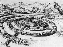
“Science Decoded: Sundaland”
May 28, 2008, The New Statesman, UK
“One of the more intriguing suggestions in the past decade is that the initial spread of humans from Africa extended along the southern coastline of Eurasia, and only later turned north into the less hospitable interior.
In his 1998 book “Eden in the East”, medical doctor and popular science writer Stephen Oppenheimer argued that Europeans are descended from a group of people who settled in what is now Southeast Asia, then a subcontinent called Sundaland that was twice the size of modern India, stretching from Burma to Borneo. The flooding of this fertile paradise as the last Ice Age ended forced these people to adapt to new lifestyles, flee to new lands, or become extinct.
DNA research led by Leeds University’s Martin Richards, one of only two professors of archaeogenetics in the world, supports this idea, showing that the stone-age people on the southeastern shore of Sundaland expanded across the newly formed island chains 12,000 years ago.
The new theory, published in the journal Molecular Biology and Evolution, is likely to draw bitter criticism from supporters of the old consensus, based on linguistics, that the area is populated today by descendants of a rice-growing people called the Austronesians who expanded from Taiwan just 4,000 years ago. ‘Some quite forceful archaeologists have been extremely reluctant to accept this’, says Professor Richards. ‘And I haven’t met a single linguist willing to give up the out-of-Taiwan argument.’
The Austronesians supposedly supplanted the indigenous hunter-gatherers, who first arrived 50,000 years ago yet were considered so insignificant that they have not even been named.
‘That was a great mistake’, Professor Richards says. His team, which includes Dr Oppenheimer, is the first to use the full mitochondrial genome rather than fragments, giving it a much more detailed picture of population movements in the distant past. Their results show that the biggest migration went not from Taiwan, but to it, and occurred much earlier.
‘The radical explanation is that the linguists are wrong and that these people spread out during the last episode of post-glacial expansion’, he said. The Austronesians may have been like the Normans, a small elite group that arrived later and took control of a larger, indigenous population, he
suggests.
Sundaland was the biggest area to be drowned as the glaciers started to retreat 19,000 years ago, raising sea levels by more than 100 metres. The second largest, Doggerland, now the southern North Sea, was submerged towards the end of the Ice Age, separating the British Isles from continental Europe.
The people living in the southeast Asian subcontinent would have been particularly hard hit by three great sea level surges, 14,000, 11,500 and 7,600 years ago, believed to have been caused by catastrophic events as the ice sheets in North America and Antarctica retreated.
Professor Richards argues that many populations will have been wiped out as their land disappeared beneath the waves.”
[Full Story]
“Spain, Egypt to investigate 19th century shipwreck”
May 22, 2008, RIA Novosti, Russia
“Spain and Egypt will start a project later this year to investigate the 19th century sinking of a ship that some believe contained the mummy of a Fourth Dynasty pharaoh, news agency MENA said.
MENA cited Egyptian Ambassador to Spain Yasser Murad as saying the countries would first hold consultations and compare historical records, and attempt to establish the location of the shipwreck.”
[Full Story]
“Archaeologists find 238-yr-old Spanish shipwreck in Chile”
May 21, 2008, The Cheers, Estonia
“A private archaeological excavation firm has discovered the remains of a 238-year-old shipwrecked Spanish galleon on the coast near the Chilean town of Curepto, located in Chile’s Region VII.
According to a report in The Santiago Times, the Spanish galleon, named ‘Our Lady of the Good Council and San Leopoldo’ was discovered by Oriflama S.A, a private archaeological excavation firm.
The Oriflama S.A’s scientific team found the ship through the use of magnetomentry, a methodology using a machine that detects materials with magnetic properties, like iron.
Most archaeologists expected to find the remains of the ship deep on the ocean floor.
But fragments of the 41-meter x 11-meter ship were discovered embedded in the sand under fairly shallow waters near where the Huenchullami River flows into the ocean.”
[Full Story]
“Divers find Caesar bust that may date to 46 B.C.”
May 14, 2008, The Associated Press, USA
“Divers trained in archaeology discovered a marble bust of an aging Caesar in the Rhone River that France’s Culture Ministry said Tuesday could be the oldest known.
The life-sized bust showing the Roman ruler with wrinkles and hollows in his face is tentatively dated to 46 B.C. Divers uncovered the Caesar bust and a collection of other finds in the Rhone near the town of Arles — founded by Caesar.
Among other items in the treasure trove of ancient objects is a 5.9 foot marble statue of Neptune, dated to the first decade of the third century after Christ.
Two smaller statues, both in bronze and measuring 27.5 inches each also were found, one of them, a satyr with his hands tied behind his back, ‘doubtless’ originated in Hellenic Greece, the ministry said.”
[Full Story]
“Navy Technology to Help NOAA Find Sunken History”
May 12, 2008, NOAA, USA:
“U.S. Navy mine-hunting technology has a potential dual use to help NOAA find historic shipwrecks by allowing maritime archaeologists to ‘see’ below the seafloor. With greater resolutions and access to deeper depths, maritime archaeologists can better understand submerged cultural and historic resources without disturbing those sites.
The Atocha, Near Key West, Florida
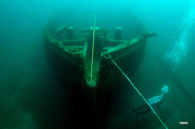
NOAA
This technology will be put through its paces at AUVfest 2008 from May 12 – 23 in Narragansett Bay, R.I. Hosted by the Naval Undersea Warfare Center (NUWC) Division Newport, R.I., Navy technical teams will deploy AUVs, or autonomous undersea vehicles, equipped with advanced mine hunting sensors.
Teams will demonstrate several mine countermeasure mission objectives, including broad area searching and mapping capabilities, confined area searching capabilities, and buried mine hunting.
A team of maritime archaeologists from NOAA, including representatives from other federal and state agencies, and universities will employ this advanced technology to survey four shipwrecks, including HMS Cerberus, a 28-gun British frigate intentionally sunk along with other ships in 1778 to avoid capture by an approaching French fleet.”
[Full Story]
“That elusive Atlantis”
May 11, 2008, The Sunday Times, Sri Lanka:
“The possibility that a highly advanced civilisation emerged and then disappeared into the depths of the ocean has captured the imagination of people over the centuries. The story of Atlantis has been the subject of countless books, films and television programmes. Archaeologists excavating in the island of Crete are confident they have found the ruins of the legendary lost continent of Atlantis.
Others claim the fabled palace of Atlantis is at the site of Knossos, the ancient capital of the Minoan civilisation. This palace was three storeys high, with 1,300 rooms and circular waterways surrounding the palace. Excavations reveal a highly developed civilisation that enjoyed multi-levelled homes with toilet and drainage facilities.
Map indicating possible sites of the lost civilization

The Sunday Times, Sri Lanka
The story of the lost continent of Atlantis starts in 355 BC, with Plato’s book Timaeus. He describes the splendour of Atlantis and how Atlantis was destroyed. Plato had come to know about Atlantis from Solon, a Greek philosopher from Athens. During a visit to Egypt, Solon was given a detailed account of the Atlantian civilisation and its destruction by Egyptian priests.
The Egyptians knew about the devastation of Atlantis, about 1,000 years before Plato heard about it. Hieroglyphic writings in Egypt describe the catastrophic destruction of Atlantis.
A 17th century artwork of Olof Rudbeck dissecting the world and revealing the secret location of Atlantis (which he believed to be hidden in Sweden.) He is surrounded by other
well-known figures of antiquity such as Plato, Aristotle and Homer.

The Sunday Times, Sri Lanka
Before the Greeks occupied Greece, a fully developed civilisation existed in Crete. When this civilization originated is not known. The Cretan civilization was also known as the Minoan civilization, named after the legendary king Minos. Crete’s capital city was Knossos. It is not known where the original Minoans came from. Some historians believe they came from Asia Minor, while others think they came from the Eastern Mediterranean.”
[Full Story]
“Odyssey Claims Its Share Of Loot”
May 10, 2008, Tampa Tribune, USA
“After Spain claimed ownership of a sunken treasure worth an estimated $500 million this week, the Tampa company that recovered the loot has fired back, saying the rightful owner is a mystery and that it’s entitled to a share of the find.
‘The company is confident in its legal position’, Tampa-based Odyssey Marine Exploration Inc. said in a statement Friday.
The response came after Spain laid claim Thursday to the entire treasure in papers filed in U.S. District Court in Tampa. It’s the latest round in a yearlong battle over the ownership of 17 tons of colonial-era coins that were recovered from the sea last year by Odyssey and transported to Tampa.
After examining photos of the seabed floor where the treasure was found and inspecting artifacts and coins recovered from the site, Spain determined that the shipwreck is the Nuestra Senora de las Mercedes, a Spanish warship sunk by the British Navy south of Portugal in 1804.
Odyssey executives said Spain is ‘jumping to conclusions’ and that it has no real proof the treasure was the cargo of the Mercedes.
‘What we have found to date is apparently a cargo from a shipwreck as opposed to an actual vessel’, Odyssey said.”
[Full Story]
“Spain launches legal war on US ‘pirates'”
May 09, 2008, The Times, UK
“Spain demanded the return of sunken treasure worth an estimated half a billion dollars yesterday, accusing Odyssey, the deep-sea exploration company that discovered it, of looting its shipwrecks.
Spanish archaeologists said that they had determined “with complete certainty” that the record haul had come from the Spanish colonial-era galleon Nuestra Señora de las Mercedes, sunk by a British fleet off the southern coast of Portugal in 1804.
‘The mystery is over’, said James Goold, a Washington-based lawyer for the Spanish Government. The treasure ‘belongs to the Spanish Armada’. Since announcing in May 2007 that it had found 500,000 gold and silver coins somewhere ‘in international waters in the Atlantic Ocean’, Odyssey has fought hard to keep details of the haul under wraps.
The Florida-based company, which uses underwater robots to search for shipwrecks, had refused to divulge the exact location of the find that it codenamed ‘Black Swan’. It also argued that because the haul included Spanish coins, it did not necessarily mean it had come from a Spanish ship.”
[Full Story]
“$500M in Sunken Treasure, and Other Great
Discoveries Undersea”
May 02, 2008, Environmental Grafitti, UK:
“The news broke yesterday that the richest shipwreck of all time had been discovered– over 500 Million USD worth of gold and silver coin–had been found in an ‘undisclosed location in the Atlantic Ocean.’
The Atocha, Near Key West, Florida
bigdog3, Environmental Grafitti
This is hardly the first time a private enterprise has gone seeking fortune in the deep and been rewarded, and it won’t be the last.
This is, of course, this week’s find. Is it the actual name of the ship? No. Will the company that found it, Odyssey Marine Exploration, ever tell us where it was? Of course not. Is it worth more than the GDP of a small county?
The press is speculating that the wreck is off the coast of England somewhere and represents a 17th century merchant ship, primarily because Odyssey petitioned to salvage a wreck in the English Channel recently. The Atocha: at the time, the richest shipwreck in the world, was a Spanish galleon that sank in 1622 as a part of what was deemed the “treasure fleet” – a group of ships that were all loaded heavily with gold bars and coins.”
[Full Story]
“Underwater archaeology lecture on Monday”
May 03, 2008, Saipan Tribune, Micronesia:
“The public is invited to attend a lecture titled ‘2008 Underwater Archaeological Survey of the Saipan Invasion Beaches: The Latest News from the Field’ which will be begin at 6pm on Monday, May 5, at the Visitors Center Theater, American Memorial Park.
Archaeologists Jason Burns and Michael Krivor of Southeastern Archaeological Research, Inc. will present the preliminary results of an underwater survey they recently completed under contract with the CNMI Division of Historic Preservation.
The survey targeted the waters off the western coast of Saipan including those adjacent to the World War II invasion beaches stretching from Agingan Point to Quartermaster Road.”
[Full Story]
“Namibian wreck yields ancient booty”
May 02, 2008, Cape Times, South Africa
“A hunt for diamonds along the coast of Namibia has led to the discovery of a shipwreck dating back around five centuries, with its booty of gold coins and bronze cannons still intact.
A spokesperson for Namdeb, the company whose miners made the discovery last month, said the ship was believed to have been the oldest wreck to be discovered in sub-Saharan Africa.
‘The site yielded a wealth of objects including six bronze cannons, several tons of copper, over 50 elephant tusks, pewter tableware, navigational instruments, weapons and thousands of Spanish and Portuguese gold coins, minted in the late 1400s and early 1500s’, spokesperson Hilifa Mbako said in a statement.
‘If this proves to be a contemporary of the ships sailed by the likes of Bartolomeus Diaz, Vasco da Gama and Christopher Columbus around the 1500s, some 500 years ago, it would be of immense national and international interest and Namibia’s most important archeological find of the century.’“
[Full Story]
“Smart ROV to recover artefacts”
April 21, 2008, Engineer Live, UK
“First to take delivery of this new generation of smart and powerful underwater vehicles is the RPM Nautical Foundation, a non-profit organisation dedicated to using state-of-the-art technology in the advancement of research into nautical archaeology.
Their new Seaeye Panther XT is packed with leading-edge technology. It will give them finger-tip manoeuvrability in strong cross currents for the delicate recovery of artefacts, and holding steady whilst filming. A special low-pressure water jet is also fitted to gently uncover valuable items without damage.
Innovative thruster design lies at the heart of this new class of underwater vehicle. Saab Seaeye engineers have cleverly doubled the thruster power whilst cutting the number of thrusters on board from ten to six. This frees valuable space within the vehicle for even more tooling and sensor packages, all of which can be readily added and changed as needed. This flexibility has enabled equipment from the Foundation’s previous ROV to be retro-fitted to their new Panther XT.”
[Full Story]
“Exploring the blue depths of the Aegean and Mediterranean”
April 17, 2008, Turkish Press, Turkey
“The coasts of Anatolia are sprinkled with ancient cities whose harbours bustled with ships engaged in the thriving sea trade of the Aegean and Mediterranean. But not every ship made it safely to harbour.
Many were wrecked in storms and sank with their cargoes to the seabed, and the remains of these have lain hidden on the seabed for long centuries. Wrecks of both merchant and warships each have their historical tale to relate, and are among the underwater sights that fascinate divers today.
No other region of the world is so rich in sunken history as the seas around Turkey. The world’s oldest known wreck was discovered at Uluburun near Kas, and after years of work was lifted to the surface and placed on exhibit.
Nautical archaeology began in Turkey, and today is recognised as a distinct branch of archaeology throughout the world. The first scientific excavation carried out entirely underwater took place at Gelidonya Point in 1960.
This was followed by excavations of the Uluburun, Serçe Limani, Roman, Yassiada Eastern Roman, Ottoman, Bozburun and Pabuçburnu wrecks, all of which passed into archaeological literature and were followed with interest all over the world. The timbers of wrecked ships are destroyed within a few years by fireworms, but their cargoes often resist erosion by the sea water for thousands of years.
Commodities of many kinds were transported in amphoras, pottery jars with pointed bases and two handles. Such jars are known to have first been used in the city of Troy in 3000 BC. The tapering pointed shape enabled them to be stacked safely in ships’ holds and kept upright so that their contents did not spill.
As well as wine and olive oil, these jars were used for grain, salted fish and many other dry commodities. Despite the passage of thousands of years, most of these amphoras remain undamaged at the bottom of the sea.”
[Full Story]
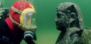
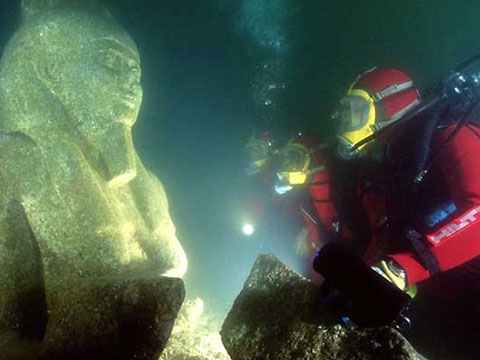
“The Sunken Treasures of Egypt to open at The Antiguo Matadero de Legazpi in Madrid”
April 15, 2008, Art Daily, USA:
“The Antiguo Matadero de Legazpi will open the exhibit The Sunken Treasures of Egypt through September 28. In the last twelve years, marine archaeologist Franck Goddio has discovered unique testimonials to Egyptian history dating from the 7th century BC to the 8th century AD off the coast of the modern city of Alexandria and in the Bay of Aboukir.
Franck Goddio discovering unique testimonials to Egyptian history
Art Daily, USA
These artefacts were lost to the sea more than one thousand years ago as the result of natural disasters. Monumental statues as well as coins, jewellery and cult objects have been located on the seabed of the Mediterranean by means of state-of-the-art technology and recovered in years of painstaking work.
Names shrouded in legend such as the ancient harbour of Alexandria and parts of the royal quarters, the long-lost city of Heracleion and parts of the city of Canopus have been re-discovered.
Around 500 objects found in these spectacular underwater excavations will be on display to the general public in the Spanish premiere of this exhibition at the Matadero de Legazpi in Madrid from 16 April through 28 September 2008. The artefacts span from the days of the last pharaohs to Alexander the Great and the period of Greek rule to the Roman conquest then to the Byzantine times until the beginning of the age of Islam.”
[Full Story]
“A unique anchor discovered”
April 11, 2008, Turkish Daily News, Turkey
“Professional diver Tevfik Camgöz discovers an ancient stone anchor bearing hieroglyphic inscriptions off the shores of Kyrenia, a major port city in northern Cyprus. The anchor was sent to the British Museum, where it was discovered to be 3,000 years old. Camgöz notes that his research is on going and does not give information about the coordinates of the spot.
Archaeology and anthropology are two sciences trying to shed light on the lives of ancient civilizations. The main aim of all the research is to find vestiges of lost cultures and civilizations, to decode the code of the universe, and hence, life.
Ancient Egypt, with its aura of mystery, is one of the most important civilizations among the cultures of Antiquity and continues to attract the attention of scientists. As the pharaohs refuse to give up their secrets, science takes a further step toward unveiling what has been hidden for millennia.
Last year, a stone anchor bearing hieroglyphic inscriptions was discovered, by chance, off the shores of Kyrenia, a significant port city in northern Cyprus. Examined by professional diver Tevfik Camgöz, the historic artifact was sent by authorities in northern Cyprus to the British Museum’s Department of Ancient Egypt and Sudan. After a number of examinations, experts found the anchor to be 3,000 years old and that it has no equal in the world.
Camgöz refrained from giving concrete information about the coordinates of the spot where he found the anchor. Noting that research is ongoing, Camgöz said, ‘the main goal of the examinations conducted on the hieroglyphics inscribed on the stone anchor is to discover why the Pharaoh sailed the waters of Cyprus. That journey by the Pharaoh might change history fundamentally.’“
[Full Story]
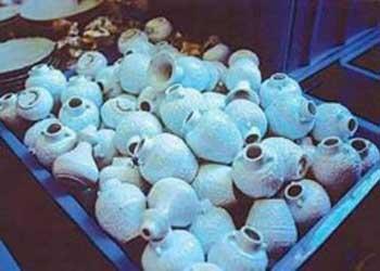
“Treasure from the sea”
April 05, 2008, The Star, Malaysia:
“Ducks frolic in a pond. Butterflies flit about. Birds sing their happy songs. Flowers – peonies and chrysanthemums – too are a part of this picture of pastoral harmony.
Another picture portrays two robed characters in deep discussion in a beautiful Chinese garden. They are ‘Immortals’, legendary beings of the Daoist sect who have attained immortality.
Broken crockery from Wanli, a Portuguese merchant ship that sunk in the South China Sea
has been turned into fashion accessories
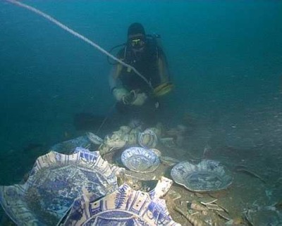
The Star, Malaysia
Everything is a symbol of something. The goose symbolises marital happiness. A vase signifies perpetual harmony. Bamboo, butterfly and lingzi stand for longevity. The scroll (representing the sacred text of the Buddhist scriptures) is a symbol of the literary class.
These are a few of the traditional Chinese motifs handpainted onto late Ming period blue-and-white porcelain or kraakware. This particular style, developed in the third quarter of the 16th century, is characterised by a panelled rim of auspicious symbols radiating into a centre medallion (i.e. the inside base of a dish).
The medallion always features a picture of nature in balanced tranquillity. Now a Malaysian-based company, Ming Blue & White, has embarked on creating a line of exclusive jewellery using these motifs and transforming them into pendants, cufflinks, brooches, rings and charm pendants.”
[Full Story]
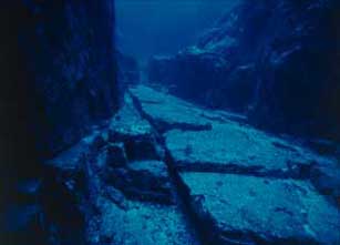
“Government of Canada releases major underwater
archaeological report on Red Bay, Labrador”
April 04, 2008, CNW Group, Canada:
“On behalf of Canada’s Environment Minister John Baird, Mr. Norman Doyle, Member of Parliament for St. John’s East, today launched a major scientific report entitled: The underwater archaeology of Red Bay: Basque shipbuilding and whaling in the 16th century.
This much-anticipated report paints a detailed picture of Basque whale hunting techniques, and of the Basque contributions in European shipbuilding and the development of transatlantic trade routes in the mid-16th century.
‘Through the Red Bay project, Parks Canada’s underwater archaeologists have set a great example in their field’, said Mr. Doyle. Our Government is proud to recognize their hard work, which will give Canadians a better understanding of Red Bay’s history.’
For a good part of the 16th century, the Basques engaged in the whaling industry on Canada’s East Coast. Years of archival research by historical geographer Dr. Selma Barkham helped identify Red Bay, Labrador, as a site of intense Basque activity. Red Bay was the largest shore whaling station, where vestiges of the Basque presence tell a compelling story of commerce and courage.
Underwater archaeologist conducting close-up photography on the San Juan site
CNW Group/Parks, Canada
Artifacts profiled in the report include four galeones or naos (ocean-going vessels), one of which is believed to be the San Juan that sunkin 1565.
Using pioneering techniques, the San Juan was systemically excavated, raised and recorded in pieces on the surface, reburied and monitored ever since in order to ensure its preservation for centuries to come.”
[Full Story]
“Boatyard Beneath The Solent’s Waves”
April 2008 Edition, Current Archaeology, UK:
“Divers from the Hampshire and Wight Trust for Maritime Archaeology (HWTMA), investigating a drowned Mesolithic site at the foot of Bouldnor Cliff, in the western Solent, have found evidence for log-boat construction dating from around 6000 BC.
The site was discovered when flint cores, flakes and bladelets were spotted in the upcast from a lobster burrow at the foot of the cliff in 2003.
Marine archaeologist at the Bouldnor Cliff site
Current Archaeology
Because the site is being scoured by aggressive currents, English Heritage recently funded a project to assess the extent and the nature of any remains.
This revealed active erosion, and the steady exposure of archaeological material from peat layers representing ancient forests, so evaluation trenches were dug during the summer of 2007, with funding from the Leverhulme Trust and the Royal Archaeological Institute.”
[Full Story]
“FSU classics professor exploring a ‘lost’ city of the Mycenaeans”
March 11, 2008, EurekAlert, USA:
“Along an isolated, rocky stretch of Greek shoreline, a Florida State University researcher and his students are unlocking the secrets of a partially submerged, ‘lost’ harbor town believed to have been built by the ancient Mycenaeans nearly 3,500 years ago.
A Google Earth image, modified by Saronic Harbors Archaeological Research Project (SHARP) co-director Thomas Tartaron, shows the location of the Korphos-Kalamianos site.
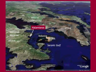
Saronic Harbors Archaeological Research Project
‘This is really a remarkable find’, said Professor Daniel J. Pullen, chairman of FSU’s Department of Classics. ‘It is rare indeed to locate an entire town built during the Late Bronze Age that shows this level of preservation.’
Pullen and a colleague, Assistant Professor of Classical Studies Thomas F. Tartaron of the University of Pennsylvania, led students from both universities in conducting an initial study of the site during May and June of 2007. What they found was unique: an archaeological site that required very little digging.
‘All of the structures were laid out in a grid pattern, which suggests that the entire community was planned and then built all at once, rather than piecemeal’, Pullen said. ‘This would indicate that the settlement was built with some strategic purpose — perhaps as a military or naval outpost.’
The settlement, referred to as Korphos-Kalamianos by Pullen and Tartaron, rests on the shores of the Saronic Gulf in the western Aegean Sea about 60 miles to the southwest of the Greek capital, Athens.
Directly across the gulf, the ancient city-state of Kolonna on Aigina likely was a rival of the emerging city-state of Mycenae, which sits about 40 miles inland to the west, during the period between 1400 and 1200 B.C. when Korphos-Kalamianos was built.”
[Full Story]
“Neanderthal treasure trove ‘at bottom of sea'”
March 10, 2008, The Independent, UK:
“Some of the world’s best preserved prehistoric landscapes survive in pristine condition at the bottom of the North Sea, archaeologists claimed yesterday.
Academic interest in what are being described as drowned Stone Age hunting grounds is likely to increase dramatically after the discovery of 28 Neanderthal flint axes on the sea bed off the East Anglian coast.
Dating from at least 50,000-60,000 years ago, they were found with other flint artefacts, a large number of mammoth bones, teeth and tusk fragments, and pieces of deer antler. The sea bed location was probably a Neanderthal hunters’ kill site or temporary camp site.
The axes – one of the largest groups ever found – were spotted by a keen-eyed amateur archaeologist when a consignment of North Sea gravel arrived at the Dutch port of Flushing.
The cache was found 8 miles off Great Yarmouth and is the most northerly point in the North Sea that Neanderthal tools have been discovered. It had been feared that the ice sheets that destroyed most pre-ice age British landscapes had done the same to the land surfaces which existed where the North Sea is now.
But archaeologists now suspect that some Neanderthal landscapes have survived under the North Sea. What’s more, they are now certain that hundreds or even thousands of square miles of post-ice age prehistoric landscapes do survive there. On land they have largely been destroyed or degraded by centuries of agriculture, later human settlement and natural erosion.”
[Full Story]
“Stone age bones and axes found off Norfolk coast”
March 10, 2008, The Guardian, UK:
“The weapons of the stone age Norfolk men who hunted mammoths on what is now the bed of the North Sea, and fragments of the beasts they slaughtered, have turned up in Holland, spotted by an amateur archaeologist in a load of gravel.
The 28 finely worked hand axes are believed to be more than 100,000 years old – possibly far older – and were described yesterday by archaeologist Phil Harding as ‘the single most important find of ice age material from below the North Sea’.
If the dating is correct – and it may be established by the fragments of bone and tooth found in the same load of gravel – the people who worked them by chipping away flakes of stone to leave a blade as sharp as a modern kitchen knife were probably Neanderthal, not Homo sapiens
The lower sea level at the time, with huge volumes of water locked up in the ice age polar ice caps, meant that the area the tools were dredged from, eight miles off Great Yarmouth and under 25 metres of seawater, was then dry land, and Britain was not yet an island.
They were found by an amateur enthusiast, Jan Meulmeester, who regularly hunts through the marine sand and gravel dredged near his home in Flushing, in the south-western Netherlands.”
[Full Story]
“Divers dig deep for the hole truth about our ancestors”
March 04, 2008, The Daily Telegraph, UK:
“Fossils from deep saltwater ‘caves’ show how human settlement has always upset the natural order, reports Roger Highfield
A pioneering study of life recorded in giant sinkholes that extend far below sea level has shown scientists the catastrophic impact that ancient communities had on their environments.
The Great Blue Hole at Lighthouse Reef Atoll, Belize
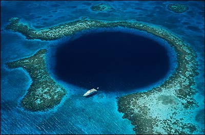
The Daily Telegraph
By swimming down into ‘blue holes’ – vertical caves in the landscape – scientists can travel back in time, exploring a treasure trove of fossils and gaining a new understanding of the prehistoric ecosystem.
The holes are so named because of the dramatic contrast between the dark blue saltwater of their depths and the lighter blue of the freshwater shallows around them. The holes, such as the Great Blue Hole at Lighthouse Reef Atoll, Belize, can sink to depths of more than 650ft and are typically found in the Caribbean on the Bahama Banks, as well as on and around the Yucatán Peninsula.
Expert divers and scientists recently carried out the first sophisticated excavation on a hole in the Bahamas, which provided a rare glimpse of life before humans arrived. The cave on Great Abaco Island, known as Sawmill Sink, contains a host of well-preserved fossils, many from species that are now extinct.
These include the first entire skeletons found in the West Indies of a 2,500-year-old tortoise and an unusual crocodile that roamed the land, along with bones from a lizard, snakes, bats and 25 species of birds, not to mention abundant plant fossils.”
[Full Story]
“Storm unveils XVI century galleon in Spain”
February 18, 2008, EiTB 24, Spain:
“The 180 tons ship was used to commercialize with The Americas. It might have belonged to Saint Medel and Celedon, sank in 1544.
According to the Spanish 20minutos web edition (text in Spanish), Spanish Civil Guard in Huelva (Spain) sealed off a few meters of El Portil beach in order to protect a discovery. If the information is confirmed, it could be one of the last few years’ most important discoveries.
The remains might have belonged to a galleon of the beginning of XVI century. The expert underwater archaeologist Claudio Lozano Guerrero-Librero, has been studying them for a few days.
Claudio Lozano considers that the ship could have belonged to Saint Medel and Celedon, two very popular saints in the Basque Country, an habitual carrack construction place. He also thinks that it could have sunk in 1544. According to his documents, the 180 tons ship was constructed at the beginning of XVI century, and it was used to commercialize in the Americas.”
[Full Story]
“Ancient Town ‘Sevtopolis’, Submerged on a Lake Bottom
to be Reconstructed”
February 18, 2008, News.bg, Bulgaria:
“At first the organizators will collect subscription list throughout the whole country, the projects author and major architect Jeko Tilev announced.
Sevtopolis or the City of Tracian King Sevt III is capital of the Odyisian state in the end of IV – beginning of III century before Christ.
Association ‘Preserve the Bulgarian’ starts action for the realizing of ‘Sevtopolis’ project
News.bg, Bulgaria
It was found and observed in 1948 – 1954 by the construction works of Koprinka dam like and afterwards, however, submerged in the lake waters.
This is the first and best preserved Thracian city in Bulgaria, located 7 km western from the Thracian capital of Bulgaria – Kazanlak and 2 kilometers from the ‘Goliyama Kosmatka’ tomb, where the biggest Thracian treasures were found.
“
[Full Story]
“‘Super-scope’ shines on Mary Rose”
February 08, 2008, BBC Science News, UK:
“Light rays, 10 billion times brighter than the Sun, are being used to probe the Tudor warship, the Mary Rose.
The research is taking place at the Diamond synchrotron, a beam-generating machine that covers the area of five football pitches.
|
The boat’s timbers are sprayed continuously
BBC Science News
|
|
Scientists are using the facility in a bid to fine-tune the conservation of the historic vessel’s timbers.
The Mary Rose, pride of Henry VIII’s English fleet, sank in 1545 and lay on the sea bed until being raised in 1982.
|
The work carried out at Diamond will help conservators understand more about the sulphur compounds buried deep within the ship’s timbers.
Researchers aim to find out how stable they are, as these can be converted to sulphuric acid when oxygen is present – threatening preservation efforts.”
[Full Story]
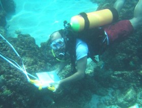
“Israel’s freshest face in archeology works underwater”
February 06, 2008, Israel 21C, Israel:
“Before the devastating 2004 Boxing Day tsunami hit Asia, Beverly Goodman had an impossible time explaining her research to peers. Since the catastrophic tidal wave struck, she has been able to remove about 10 slides from her presentation.
She makes no light of the event, but was surprised to see how overnight the world had educated itself about this unique force of nature, which was then, and remains today, an important focal point of her research.
Goodman, 33, is an underwater archeologist who has invented new underwater coring methods to better understand climatic events at sea and in lakes. Her research tracks historical changes in the environment – such as tsunamis – and how these changes have impacted people and coastlines.
|
Out on a ‘dig’:
Beverly Goodman straps on her diving gear to explore Israel’s underwater archeology
Israel 21C, Israel
|
|
Her research may give science new clues about the coastal environment in the context of global warming. Are the seas rising? Could a melting glacier break off and create a tsunami? Will storms and floods increase as the earth warms?
Goodman’s questions might be more local in nature, but her work has global significance by adding to the information science holds about earth events and climate change.
|
Sifting through broken shells and sediment from coring samples, she has determined that at least three ancient tsunamis struck Israel’s port of Caesarea in the past. Concurrently, she also works in the Red Sea’s Gulf of Aqaba to determine how local flood cycles and sea levels have changed over time.
Goodman is one of a dozen researchers around the world exploring a new field known roughly as geo-archeology, she says, but even Goodman stumbles a bit coming up with a precise definition.”
[Full Story]
“Nanhai one´s in underwater archaeology”
February 05, 2008, CCTV, China:
“There’s been much hype surrounding the sunken ancient Chinese merchant boat, which was raised from the depths of South China Sea in December. But there’s more to it than the public storm.
|
Archeologists affiliated with the national museum say it marks a milestone in China’s underwater archeology
CCTV/Xinhua, China
|
|
And over the weekend, they also showcased some of the earliest finds from the vessel.
Archeologists say the Nanhai One, or ‘South China Sea One’, China’s first underwater archeological find, is also the most important one so far. China launched its underwater archaeology campaign in 1987, the year Nanhai One was discovered.
|
After twenty years of development, China is now a leader in this field in Asia. Archaeologists give a lot of credit to the discovery of Nanhai One.
Prof. Zhang Wei, Underwater Archaeology Research Center, said, ‘The discovery provided us a lot of valuable experience in underwater archaeology. It’s something of a blessing for us, as a young team then, to find this cultural relic, recognized as one of the oldest and biggest merchant boat sunk in South China Sea.’“
[Full Story]
“Ram Setu project worries Coast Guard”
January 31, 2008, CNN-IBN Live, India:
“There is a new twist to the Ram Setu controversy. The Coast Guards Director General has told CNN-IBN that the Sethusamudram project poses security threat to India.
Vice Admiral Contractor was echoing remarks similar to those made by the Navy Chief, Admiral Sureesh Mehta, recently. His statement comes at a time when the BJP is opposing the project tooth and nail, insisting that it will damage a precious historical heritage.
|
When the sea is dredged it will damage a precious historical heritage
CNN-IBN Live, India
|
|
On the other hand Tamil Nadu Chief Minister Karunanidhi has made it a prestige issue. His party says the Sethusamundram is not a man-made structure.
The Archaeological Survey of India had earlier corroborated the DMK’s stand. However, the Coast Guard Chief’s remarks are expected to give the BJP fresh ammunition on the Setusamudram project.
|
Meanwhile, the Supreme Court has granted the Centre four weeks to make its stand clear on the issue. The apex court directed the Government to file two separate affidavits, one on the alignment of the project and other giving details of the studies that have been undertaken to ascertain whether Ram Setu is an ancient monument.
The Supreme court had already directed the authorities not to damage the Setu in any manner while carrying out dredging activities.”
[Full Story]
“SC ticks off Jaya, says Centre to decide on Ram Setu’s status”
January 29, 2008, The Economic Times, India:
“The Supreme Court on Monday, taking strong exception to Tamil Nadu former chief minister J Jayalalithaa’s petition seeking declaration of Ram Setu as a national monument by restraining the authorities from executing the Sethusamundram project by destroying the revered structure, threw the ball back to the Centre’s court.
‘It is the appropriate authority to decide whether to declare it as a national monument or not’, said a bench comprising Chief Justice K G Balakrishnan, Justice Tarun Chatterjee and Justice R V Raveendran.
The leader of Opposition in the state had said in her petition, ‘leaving aside the mythological dimensions and the sentimental value of the structure to millions of the people in India and other South East Asian countries, the structure is worthy of protection purely from historical and archaeological standpoints. By reason of its age and its historical and cultural importance, Rama’s Bridge is indeed an ancient monument within the meaning of Sec 2 (a) of the Ancient Monuments and Archaeological Sites and Remains Act, 1958’
Article 49 of the Constitution provides that it shall be the obligation of the state to protect every monument or place of artistic or historic interest declared by a Parliament law to be of national importance from destruction, etc, she said.”
[Full Story]
“Sea battle over the ocean’s ancient treasures”
January 25, 2008, San Francisco Chronicle, USA:
“The playground legal principle ‘Finders keepers, losers weepers’ is being put to the test in an international dispute over what could be the richest sunken treasure ever found: 17 tons of silver coins brought up from a centuries-old shipwreck.
A Florida treasure-hunting company, Odyssey Marine Exploration, found the wreck at the bottom of the Atlantic and argues that the age-old law of the high seas entitles the finders to most or all of the booty, said to be worth around $500 million.
But the government of Spain suspects the ship is Spanish and says it has never expressly abandoned any of its vessels lost at sea. The kingdom has made it clear that if the treasure does have some connection to Spain, it wants every last coin returned.
The case is being watched closely because there could be more disputes like it, now that sonar, remote-control submersible robots and deep-sea video are enabling treasure hunters like Odyssey to find ships that went to the bottom centuries ago and were written off as unrecoverable because no one could imagine finding anything so far beneath the waves.
‘The question is, just because you’re the first one out there to get it, should you get to keep it – especially if it belongs to someone else?’ said James Delgado, director of the Institute of Nautical Archaeology at Texas A&M University and a critic of commercial treasure hunters.”
[Full Story]
“Cyprus Divers to Dig Out Ancient Ship”
January 25, 2008, The Associated Press, USA:
“Marine archaeologists will begin work in June to uncover the sand-buried hull of a 2,300-year-old ship thought to have been ferrying wine when it sank off the coast of Cyprus, researchers said Thursday.
The ship, dating from the fourth century B.C., is one of only a few to have been found so well-preserved, and it may shed light on the nautical and economic history of the period in the east Mediterranean, said Stella Demesticha, a University of Cyprus visiting marine archaeologist.
Underwater photographs from initial surveying dives in November show dozens of amphorae — large terra-cotta vases used in antiquity to transport liquids and solid foodstuffs — lying on the seabed in the shape of the ship.
The ship was sought to have been transporting wine from the Greek island of Chios when it sank. The amphorae closely resemble others found to contain Chios wine, but may have been used to transport other goods in ancient sea trade.
Demesticha said researchers believe the vessel’s wooden hull may be preserved under tons of sand. Archaeologists have not released the pictures, as research is still at a preliminary stage.”
[Full Story]
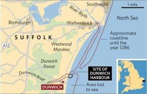
“Britain’s Atlantis: the search for our lost capital”
January 22, 2008, The Independent, UK:
“In medieval times, Dunwich was a thriving rival to London. Then it was swallowed by the sea. Now, thanksto technological advances, the ancient settlement may soon be visible once more.
This British Atlantis – with its eight churches, five houses of religious orders, three chapels and two hospitals – is now about to be exposed to human gaze for the first time since the first
of a series of great storms and sea surges hit the East Anglian coast in 1286 and
began the process of coastal erosion which led to the city’s disappearance.
The Independent, UK
Around midnight, at certain tides, church bells can still be heard tolling from the lost city of Dunwich. Or so local legend has it. The sound comes from beneath the waves of the North Sea, for Dunwich – one of England’s most prosperous medieval centres, a place some consider a rival to 14th-century London – has been sunk beneath the waters for 500 years and more.
Visit Dunwich today and you will encounter a quiet Suffolk coastal village with steeply sloping shingle beaches. From time to time the waves move the pebbles to expose the great black sea defences which lie amid the stones like great beached whales, designed to slow the longshore drift of the beach into the oblivion to which the once great city has been consigned. Today the real Dunwich lies out there beneath the cold grey waters, 50 feet down and perhaps a mile out.
This British Atlantis – with its eight churches, five houses of religious orders, three chapels and two hospitals – is now about to be exposed to human gaze for the first time since the first of a series of great storms and sea surges hit the East Anglian coast in 1286 and began the process of coastal erosion which led to the city’s disappearance.
For the past 30 years one man, Stuart Bacon, a marine archaeologist and director of the Suffolk Underwater Studies, has dedicated himself to discovering what lies beneath the waves. He has made more than 1,000 dives on the medieval site since 1971 but with limited success. High silt levels in the water mean that visibility is limited to just a few centimetres.”
[Full Story]
“New survey to reveal ‘Britain’s Atlantis'”
January 16, 2008, Innovations-Report, Germany:
“The lost city of Dunwich, Britain’s own underwater ‘Atlantis’, which has captured the imagination of people for centuries, could be revealed for the first time with high-tech underwater sonar.
Professor David Sear, of the University of Southampton, and marine archaeologist Stuart Bacon, will explore the ancient sunken city, off the Suffolk coast, in the early summer.
Dunwich, fourteen miles south of Lowestoft, was once a thriving port, and in the 14th century similar in size to London. However, storms, erosion and floods over the past six centuries have almost wiped out this once prosperous city, and the Dunwich of today is a quiet coastal village.
The project will use the latest underwater acoustic imaging technology to assess the existence of any remains from the city that lies between 10ft (3m) and 50ft (15m) down.
Professor Sear comments: ‘We will be applying new technology to the investigation of what has become known as “Britain’s Atlantis”, and making this information publicly available. Technical advances, such as side-scan multibeam sonar have massively improved our ability to create accurate acoustic images of the seafloor, and this survey should greatly enhance our knowledge of the site.’“
[Full Story]
“Underwater city could be revealed”
January 14, 2008, BBC News Online, UK:
“Britain’s own underwater ‘Atlantis’ could be revealed for the first time with high-tech underwater cameras.
Marine archaeologist Stuart Bacon and Professor David Sear, of the University of Southampton, will explore the lost city of Dunwich, off the Suffolk coast.
|
Dunwich has been dubbed the UK’s ‘Atlantis’
BBC News Online
|
|
Dunwich gradually disappeared into the sea because of coastal erosion. ‘It’s about the application of new technology to investigate Britain’s Atlantis, then to give this information to the public’, Professor Sear said.
Mr Bacon, director of the Suffolk Underwater Studies, first located the debris of the lost city in the 1970s.
|
‘I know the site like the back of my hand because I have dived on it about 1,000 times’, said Mr Bacon who has been working on the medieval site since 1971. ‘We have found three churches and one chapel.’
There is diving evidence of debris from lost chapels and churches but high silt levels in the water means visibility is only a few centimetres.”
[Full Story]
“Shipwreck artifact resurfaces”
January 11, 2008, Kodiac Daily Mirror Alaska:
“Three years after coming off the bottom of Monk’s Lagoon, a historic artifact has surfaced again in Alaska.
The metal cylinder that served as the hub of the steering wheel onboard the Russian American bark Kad’yak bears the ship’s name in bold Cyrillic letters. It’s discovery by a team of underwater archaeologists from East Carolina University allowed positive identification of the find, recognized as the oldest shipwreck in Alaska waters.
This weekend it makes its first public appearance since July 2004 as part of the Alaska Office of History and Archaeology booth during Ocean Family Day at the Anchorage Museum at Rasmuson Center (formerly the Anchorage Museum of History and Art).
The artifact has not been seen in Kodiak since the ECU unveiled their discovery. After resting submerged in cold seawater off Spruce Island for 144 years, it needed careful handling to make it safe for study and display.”
[Full Story]
“Message in a 2,400-year-old bottle”
January 08, 2008, The Daily Telegraph, UK:
“A new DNA technique could provide a revolutionary insight into the lives of the Ancient Greeks – using jars that have lain on the seabed for millennia.
These amphoras were the cargo containers of the ancient world, used for shipping all kinds of things, from wine to olive oil.
Buried treasure: amphoras from a shipwreck lie on the seabed
The Daily Telegraph
Studying those left in shipwrecks could tell us much about the trade, agriculture and climate of historic societies – except that the contents wash away over the centuries, leaving archaeologists with glorified empty bottles.
Now a team from Massachusetts Institute of Technology and Woods Hole Oceanographic Institution in the US and Lund University in Sweden has performed the first successful extraction of DNA from the remains of a 2,400-year-old shipwreck off the Greek island of Chios.
The wooden merchant ship sank in the fourth century BC, coming to rest 70 meters down.”
[Full Story]
“Silt, Mystery Surround Old Shipwreck”
January 04, 2008, The Hartford Courant:
“While flying across the Connecticut River in July 2001, pilot Joseph Roberts spotted something just beneath the surface of the water that he’d never seen before: a symmetrical shape that turned out to be the remnants of a large ship. Crews traveled to the site to catch a glimpse of the sunken ship and possibly dig up the history behind it.
More than six years after the discovery drew State Archaeologist Nicholas Bellantoni, maritime historians, divers and others to the East Windsor site, local historians are still conflicted as to where the boat came from, what it carried and when it sank.
Some believe the remains of the vessel, which was at least 22 feet wide and 77 feet long, were those of a passenger ferry that ran from Hartford to Springfield, and then to Holyoke.
‘It was a packet boat, a side-wheeler’, said George Butenkoff, a member of the East Windsor Historical Society. ‘We’ve just never been able to figure out what the name of it was’.
But others believe the boat might have carried construction materials to towns along the river. Bellantoni said his team found large slabs of what appear to be brownstone at the site of the sinking.”
[Full Story]
“Abu Dhabi’s marine treasure island”
January 04, 2008, Gulf News, Abu Dhabai:
“From 7,000-year-old houses to dugongs and turtles, the island of Marawah offers a hearty package to visitors. The island, situated off Abu Dhabi, was recently in the news for becoming the first Biosphere Reserve in the country after being recognised by Unesco.
|
Marawah Island was declared a marine protected area in 2001 and hosts 60 per cent of the population of dugongs in the world.
Gulf News, Abu Dhabai
|
|
Home to important marine and coastal ecosystems, including sea grass beds, coral reefs and mangroves, the Marawah Biosphere Reserve is managed by the Environment Agency – Abu Dhabi (EAD)
Marawah Marine Protected Area ((MPA) is spread over 4,255 sq km and is the largest MPA in the region. It is 150km from the city of Abu Dhabi.
The island has great cultural and archaeological significance with the presence of more than 20 sites dating back to the Stone Age.
|
Houses as old as 7,000 years from Stone Age were unearthed a few years back along with the remains of the oldest inhabitants of the island.
Archaeological sites identified on the island date back to the Bronze Age, Iron Age the late pre Islamic period as well as Islamic period. A large Islamic graveyard, with over 60 burials, and an important fragment of pottery from the Late Stone Age were found.”
[Full Story]
|
|
To understand why this News Page is sometimes late here is some information about Fibromyalgia
The Morien Institute
Research Projects
if you would like to support our Marine Archæology research
please send us a book

from our Wish List
“Eden in the East: The Drowned Continent of Southeast Asia”
by
Stephen Oppenheimer

Buy This Book From:
Amazon.com
Amazon.co.uk
“A book that completetly changes the established and conventional view of prehistory by relocating the Lost Eden – the world’s 1st civilization – to SouthEast Asia. At the end of the Ice Age, SouthEast Asia formed a continent twice the size of India, which included Indochina, Malaysia, Indonesia and Borneo.
The South China Sea, the Gulf of Thailand and the Java sea, which were all dry, formed the connecting parts of the continent. Geologically, this half sunken continent is the Shunda shelf or Sundaland.
He produces evidence from ethnography, archaeology, oceanography, from creation stories, myths and sagas and from linguistics and DNA analysis, to argue that this founder civilization was destroyed by a catastrophic flood, caused by a rapid rise in the sea level at the end of the last ice age.”
…
exclusive
…
October 2002
Morien Institute
illustrated interview with
Professor Masaaki Kimura
of the University of the Ruykyus,
Okinawa, Japan, regarding
the discovery of:
“Megalithic structures found underwater off the coast of
Yonaguni-jima, Japan”
…
exclusive
…
June 2002
Morien Institute
illustrated interview with
Dr Paul Weinzweig
of Advanced Digital Communications,
Havana, Cuba, regarding
the discovery of:
“Megalithic urban ruins discovered off the coast of Cuba”
“Maritime Archaeology:
A Technical Handbook”
by
Jeremy Green
EU English Edition
“Jeremy Green’s systematic overview of maritime archaeology offers a step-by-step description of this fast-growing field. With new information about the use of computers and Global Positioning Systems, the second edition of this handbook shows how to extract as much information as possible from a site, how to record and document the data, and how to act ethically and responsibly with the artifacts.
Treating underwater archaeology as a discipline, the book demonstrates how archaeologists, “looters,” academics, and governments interact and how the market for archaeological artifacts creates obstacles and opportunities for these groups.
Well illustrated and comprehensive in its approach to the subject, this book provides an essential foundation for everybody interested in underwater environments, submerged land structures, and conditions created by sea level changes.”
“Discoveries: Underwater Archaeology”
by
Jean-Yves Blot
&
Alexandra Campbell
EU English Edition
“Some of the most exciting archaeological discoveries aren’t made by Indiana Jones wannabes prowling through the jungle in search of forgotten cities or by Egyptologists looking for lost passageways in the pyramids. They are found by divers exploring shipwrecks such as the Titanic and the U.S.S. Monitor.
Every now and then they even uncover the remains of human settlements sleeping beneath the waves. Underwater Archaeology is an inexpensive and colorful book about the people who do this work and what they sometimes bring to the surface–a great introduction to the subject. It is another fine title in the Discoveries series of books published by Harry N. Abrams.”
“Man: 12, 000 Years Under the Sea
a Story of Underwater Archaeology”
by
Robert F. Burgess
&
George F. Bass
EU English Edition
“This encyclopedia is the first comprehensive reference book on the discovery and recovery of underwater archaeological remains around the world and across time. Written by archaeologists and other scientists who have made the discoveries, it offers a wealth of authoritative and accessible information on shipwrecks, drowned cities, ritual deposits, and other relics of our submerged past.
The volume’s 450 alphabetically arranged entries cover sites from prehistory to the modern era (including Titanic), legislation and legal issues, organizations, nations and regions, research themes, and technology and techniques. Length generally ranges from two paragraphs for reef netting and Southampton Centre for Maritime Archaeology to about four pages for Great Lakes and remote sensing.
More than 100 illustrations in color are complemented by more than 200 black-and-white drawings and photos. Most entries append a bibliography, usually of recent books, journal articles especially from the leading journal of the discipline, International Journal of Nautical Archaeology, and professional conference papers.”
“Encyclopedia of Underwater and Maritime Archaeology”
by
James P. Delgado
(Editor)
EU English Edition
“This encyclopedia is the first comprehensive reference book on the discovery and recovery of underwater archaeological remains around the world and across time. Written by archaeologists and other scientists who have made the discoveries, it offers a wealth of authoritative and accessible information on shipwrecks, drowned cities, ritual deposits, and other relics of our submerged past.
The volume’s 450 alphabetically arranged entries cover sites from prehistory to the modern era (including Titanic), legislation and legal issues, organizations, nations and regions, research themes, and technology and techniques. Length generally ranges from two paragraphs for reef netting and Southampton Centre for Maritime Archaeology to about four pages for Great Lakes and remote sensing.
More than 100 illustrations in color are complemented by more than 200 black-and-white drawings and photos. Most entries append a bibliography, usually of recent books, journal articles especially from the leading journal of the discipline, International Journal of Nautical Archaeology, and professional conference papers.”
“Submerged Cultural Resource Management: Preserving and Interpreting Our Sunken
Maritime Heritage”
James D. Spirek
(Editor)
&
Della A. Scott-Ireton
(Editor)
EU English Edition
“This vital book is a collection on the various ways archaeologists and resource managers have devised to make available and interpret submerged cultural resources for the public, such as underwater archaeological preserves, shipwreck trails, and land-based interpretive media and literature.
The concept of preserves, parks, and trails has proven to be an effective and popular method of public education and heritage tourism with the end result being a greater public understanding of the value of preserving and protecting shipwrecks, and other submerged cultural resources, for the future.
Within each contribution, the authors focus on: legislation; economic benefits; interpretation methods; problems and successes; future directions regarding their preserve, park, or trail programs.
Various approaches to the concept have been explored and this book is an effort to make available our experiences in the management of submerged cultural resources for the public. This volume is an invaluable resource to underwater archaeologists, cultural and heritage resource managers, museum and heritage educators and those studying these professions.”
“Successful Underwater Photography”
by
Brian Skerry
&
Howard Hall
EU English Edition
“From fundamental principles of photographing marine life to making a living selling underwater photographs, Successful Underwater Photography provides an unlimited wealth of practical advice, surefire strategies, and tested tips for taking extraordinary photos of elusive underwater subjects.
Written by two top photographers who specialize in marine photography, this solid, lavishly illustrated field guide provides no-nonsense information on such topics as taking available-light photographs, silhouettes, marine wildlife portraits, close-focus wide angle photographs, and extension tube photographs to name just a few. Readers will also find proven guidance for purchasing underwater photographic equipment, taking photos of shipwrecks, and repairing and maintaining field equipment.
“Digital Imaging for the
Underwater Photographer”
by
Jack Drafhal
&
Sue Drafhal
EU English Edition
“How to Solve Common Problems, Repair Images and Create Dazzling Presentations; Focusing on the aspects of digital imaging that are most important to underwater photographers, this book is a step-by-step guide for the professional and amateur alike to improve their images and presentations.
Designed to help the underwater photographer make a smooth transition to digital imaging, this book discusses how to digitally refine, correct, and enhance underwater photographs. Detailing the equipment necessary, it also includes a discussion on the essentials of
scanning. There is also extensive information on Adobe Photoshop, and how it can be used to edit underwater pictures.
Designed to help the underwater photographer make a smooth transition to digital imaging, this book discusses how to digitally refine, correct, and enhance underwater photographs. Detailing the equipment necessary, it also includes a discussion on the essentials of scanning. There is also extensive information on Adobe Photoshop, and how it can be used to edit underwater pictures.
“Beneath the Seven Seas: Adventures with the Institute of Nautical Archaeology”
by
George F. Bass
EU English Edition
“Readers will dive nearly 200 feet with Cemal Pulak on a royal ship that sank over 3,300 years ago off the Aegean coast of Turkey, and explore with Donny Hamilton the streets and houses of the richest English colony in the New World, the infamous pirate stronghold of Port Royal, Jamaica, swallowed by the sea in 1692.
They will accompany famed undersea explorer Robert Ballard, discoverer of the Titanic, as he and Cheryl Ward search for shipwrecks in the deep, oxygen-free waters of the Black Sea. They will wade with archaeologist Fred Hocker through mud along the bank of a South Carolina river, and then sail through a gale with Susan Womer Katzev on a full-scale replica of the best-preserved ancient Greek ship yet raised from the depths of the Mediterranean.
The book describes the tragic loss, within sight of their loved ones, of seamen returning home to Portugal in 1606, at the end of a two-year voyage to the East on the Nossa Senhora dos Martires, and then describes the fate of the crew of another Portuguese ship, the Santo Antonio de Tanna, which sank off Mombasa, Kenya, while trying to lift the siege of Fort Jesus by Omani Arabs in 1697.”
“Underworld: The Mysterious Origins
of Civilization”
by
Graham Hancock
&
Santha Faiia
(Photographer)
EU English Edition
“From Graham Hancock, bestselling author of Fingerprints of the Gods, comes a mesmerizing book that takes us on a captivating underwater voyage to find the ruins of a lost civilization that’s been hidden for thousands of years beneath the world’s oceans.
While Graham Hancock is no stranger to stirring up heated controversy among scientific experts, his books and television documentaries have intrigued millions of people around the world and influenced many to rethink their views about the origins of human civilization. Now he returns with an explosive new work of archaeological detection.
In Underworld, Hancock continues his remarkable quest underwater, where, according to almost a thousand ancient myths from every part of the globe, the ruins of a lost civilization, obliterated in a universal flood, are to be found.”
“Maritime Archaelogy: A Reader of Substantive and Theoretical Contributions”
by
Lawrence E. Babits
(Editor)
&
Hans Van Tilburg
(Editor)
EU English Edition
“This unique text presents a variety of writings discussing the spectrum of theory and practice in maritime archaeology from its beginnings in the late 1940s to the early 1990s.
It is the first such comprehensive reference available, covering the field’s history, approaches to fieldwork, technical developments, and areal bibliographies.
Notable attention is given to the scientific method in two classic chapters by Platt and Chamberlin, augmented by flow charts and examples. Comparative readings explore the differing views of academics, amateurs, and treasure hunters on the contentious subject of underwater resources. Students will find no more complete introduction to the subject.”
“Archaeology and the
Social History of Ships”
by
Richard Gould
EU English Edition
“Maritime archaeology deals with shipwrecks and is carried out by divers rather than diggers. But this is by no means a marginal branch of archaeology.
It embraces maritime history, analysing changes in ship-building, navigation, reconstructing the infrastructure of waterborne commerce, and offers fresh perspectives on the cultures and societies that produced the ships and sailors.
Drawing on detailed and recent case studies, Richard Gould provides an up-to-date review of the field, and a clear exposition of new developments in undersea technologies. He also argues for the careful management of underwater cultural resources.”
“Ships and Seamanship in
the Ancient World”
by
Lionel Casson
EU English Edition
“Lionel Casson’s encyclopedic study is the first of its kind to use underwater archaeological data to refine and area of scholarship that had, for the most part, relied on ancient texts and graphic representations.
Tracing the history of early ships and seamanship from pre-dynastic Egypt to the Roman empire, from skiffs and barges to huge oared warships and royal yachts, Casson describes not only the ships themselves, but also the make-up and training of the crews, placement of weaponry, how cargo was stored, methods of navigation, harbor facilities, and the ways ships were named.”
|