|
“China to excavate cabins on 800-year-old
recovered merchant wreck”
June 21, 2009, XinhuaNet, China:
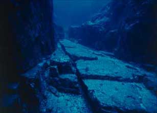
“Chinese archaeologists have won permission to start an ‘excavation’ into the cabins of the 800-year-old shipwrecked merchant vessel Nanhai No. 1, the local government said Sunday.
The municipal government of Yangjiang, Guangdong Province, where the Nanhai No.1 boat has been preserved since it was hoisted from a depth of 30 meters below the South China Sea at the end of 2007, won permission from the State Administration of Cultural Heritage in May for the ‘excavation’, Feng Shaowen, director with the municipal publicity bureau, told Xinhua.
The 30-meter-long vessel ship has been soaked in a sealed pool in the ‘Crystal Palace’ at the Marine Silk Road Museum in Yangjiang.
The glass pool – 64 meters long, 40 meters wide, 23 meters high and about 12 meters in depth – was filled with sea water and silt to replicate the water temperature, pressure and other environmental conditions of the seabed where the vessel had lain for centuries.
The details of the excavation have not been released so far but it could last three to five years.”
[Full Story]
“Roman shipwreck find”
June 17, 2009, iAfrica / AFP, South Africa:
“A shipwreck believed to date back to Roman times was found at the bottom of Montenegro’s Boka Kotorska bay, officials said on Tuesday.
‘We believe we have found the wreckage of a ship that could have been used to transport goods’, Montenegro’s regional Cultural Heritage Preservation Institute said in a statement.
Officials refused to reveal the location of the shipwreck until the area was fully secured.”
[Full Story]
“Sea gives up Neanderthal fossil”
June 15 2009, BBC News, UK:
“Part of a Neanderthal man’s skull has been dredged up from the North Sea, in the first confirmed find of its kind.
Scientists in Leiden, in the Netherlands, have unveiled the specimen – a fragment from the front of a skull belonging to a young adult male.
The fragment of skull belonged to a young adult male
BBC News
Analysis of chemical ‘isotopes’ in the 60,000-year-old fossil suggest a carnivorous diet, matching results from other Neanderthal specimens.
The North Sea is one of the world’s richest areas for mammal fossils.
But the remains of ancient humans are scarce; this is the first known specimen to have been recovered from the sea bed anywhere in the world.”
[Full Story]
“Science aids inventory of Florida Keys shipwrecks”
June 13 2009, The Miami Herald, USA:
“Archaeologists and biologists cooperate to explore, date and map the hundreds of shipwrecks off the South Florida coast.
About 18 feet underwater off Key Largo lies a mystery ship, one of hundreds in just these waters.
Its cargo, name and destination are unknown. All that remains of the wreck are planks of timber, iron rods and some pieces of coal.
State underwater archaeologist Roger Smith and his team will spend about two weeks mapping the site that has become a bountiful coral reef.
In time they will also try to piece together what ship this was, its voyage and whether it should be nominated for the National Register of Historic Places.
The work is part of an ongoing effort to take an inventory of Florida’s shipwrecks and artifacts, which number around 300 off Key Largo alone.”
[Full Story]
“Wild weather uncovers treasure trove of shipwrecks”
June 11 2009, ABC News, Australia:
“Turbulent weather on the New South Wales north coast has revealed a treasure trove of maritime history.
Five shipwrecks between Evans Head, South West Rocks and Forster have been uncovered by shifting sands and wild oceans.
State maritime archaeologist Tim Smith says there are records of 1,800 known shipwrecks but only about 10 per cent of those have been found.
Mr Smith says archaeologists have to work quickly before the sea reclaims its booty.”
[Full Story]
“Why is there a storm brewing over the right
to plunder shipwrecks?”
June 09 2009, The Independent, UK:
“Magistrate Mark A Pizzo, sitting in the US Federal Court at Tampa, Florida, might not be a major figure in international law but he has just made a potentially vital decision on the future of 3,000 treasure-laden shipwrecks that lie in the world’s oceans.
Mr Pizzo ruled that an American marine archaeology company should return gold and silver coins worth £300m to the Spanish government after the bullion was removed from a sunken vessel in the Atlantic.
Six of the world’s most glittering wrecks
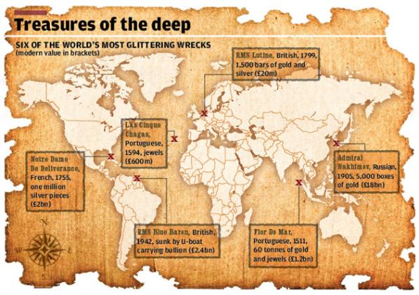
Independent Graphics
Odyssey Marine Exploration removed the 500,000 coins, weighing 17 tonnes, in 2007 and flew them back to its Florida base from Gibraltar.
The move was greeted with fury by the Spanish government, which insisted the wreck was the Nuestra Senora de las Mercedes, a frigate which was sunk by the Royal Navy in 1804.
Odyssey insisted there was not enough evidence to prove the site, which it called Black Swan, was the Nuestra Senora and, even if that were the case, the ship was on a commercial mission and its cargo could be legitimately recovered under salvage law and shared among salvors and claimants.”
[Full Story]
“Archeological evidence of human activity found
beneath Lake Huron”
June 08 2009, EurekAlert, USA:
“More than 100 feet deep in Lake Huron, on a wide stoney ridge that 9,000 years ago was a land bridge, University of Michigan researchers have found the first archeological evidence of human activity preserved beneath the Great Lakes.
The researchers located what they believe to be caribou-hunting structures and camps used by the early hunters of the period.
‘This is the first time we’ve identified structures like these on the lake bottom’, said John O’Shea, curator of Great Lakes Archaeology in the Museum of Anthropology and professor in the Department of Anthropology.
‘Scientifically, it’s important because the entire ancient landscape has been preserved and has not been modified by farming, or modern development. That has implications for ecology, archaeology and environmental modeling.’.
A paper about the findings is published in the June 8 issue of Proceedings of the National Academy of Sciences. Co-authors are O’Shea and Guy Meadows, director of the Marine Hydrodynamics Laboratories and a professor in the departments of Naval Architecture and Marine Engineering, and Atmospheric, Oceanic and Space Sciences.”
[Full Story]
“Ancient Underwater Camps, Caribou Traps in Great Lake?”
June 08 2009, National Geographic News, USA:
“Under North America’s second largest lake, robot-assisted archaeologists may have discovered prehistoric American camps and long ‘drive’ lanes built to guide caribou to their deaths, a new study says (caribou pictures and facts).
On what was once dry land, the structures likely date back 10,000 to 7,500 years. At the time, a vast land bridge divided what is now Lake Huron, researchers say (Lake Huron map).
Now mussel- and algae-encrusted, the features were uncovered by sonar and underwater robots at depths ranging from 60 to 140 feet (18 to 43 meters).
One of the structures in the lake, which straddles Michigan and Ontario, Canada, appears to be a line of carefully placed rocks that stretches longer than a football field.
The line resembles lanes still used by Arctic caribou hunters, according to the study.”
[Full Story]
“Did Paleo-Indians hunt below the modern Great Lakes?”
June 08 2009, Scientific American, USA:
“What is now part of Lake Huron’s obscured floor became a dry land bridge between modern-day Presque Isle, Michigan and Point Clark, Ontario when lake levels dipped some 7,500 to 10,000 years ago.
But could it have been a rich hunting ground for Paleo-Indians?
The site on the bed of Lake Huron
John O’Shea / University of Michigan
Previous wisdom has held that ‘most [sites] are presumed lost forever beneath the lakes’ —wh ich were carved out and filled in by receding glaciers about 10,000 years ago—note the authors of a new study, published today in Proceedings of the National Academy of Sciences, which has found traces of what appear to be stone structures, hunting blinds, dwelling sites and caribou drive lanes hidden under the mussels and algae at the bottom of the lake.
[Full Story]
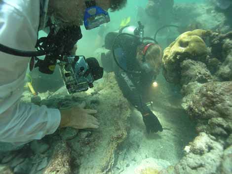
“Researchers dive into ancient treasure”
June 07 2009, European Research, Belgium:
“Archaeologists from Britain’s University of Nottingham and Greece’s Ephorate of Underwater Antiquities of the Ministry of Culture are using digital equipment to unlock the mystery behind the ancient Greek town of Pavlopetri, thought to be the oldest submerged town in the world.
Discovered and mapped by researchers of the Institute of Oceanography at Cambridge University in 1968, no other work has since been conducted at the site. This project could fuel underwater archaeology in the future.
A grave in Pavlopetri
University of Nottingham
The ruins of Pavlopetri, which lie in three to four metres of water just off the coast of Laconia in the Peloponnese, date from at least 2 800 BC. Buildings are still intact, and streets, courtyards, and chamber tombs exist as well.
Experts believe the ruins belong to the Mycenaean period (circa 1680-1180 BC). Dr Jon Henderson from the Underwater Archaeology Research Centre (UARC) at the University of Nottingham is the first archaeologist in 40 years to obtain special permission from the Greek Government to examine the submerged town.
This project will help shed light on how the town was developed, when it was occupied, what it was used for, and why it disappeared under the sea.”
[Full Story]
“Long-lost Armenian ship, the stuff of legend, to become
a ‘living museum’ in the Caribbean”
June 05 2009, The Armenian Reporter, Armenia:
“This has been a mystery three centuries in the making.
Burned and scuttled off the coast of this former Spanish colony, an Armenian merchant ship captured by British privateer Captain William Kidd has since become the stuff of legend and an elusive prize for treasure hunters.
Indiana University’s Charles Beeker (l.) and Fritz Hanselmann collect a sample
from what is believed to be the wooden keel of the Quedagh Merchant
under a pile of coral-shrouded cannons on June 2
Eleanor Seagle / The Armenian Reporter
Since it was accidentally found in December 2007, the researchers involved have called Quedagh Merchant an unprecedented discovery of its kind in recent history.
According to British records, Kidd captured the Quedagh Merchant (also known as Cara Merchant) in January 1698 from Armenian traders near the coast of India and then sailed on it to the Caribbean.
In 1701, after a two-year public trial in London, Kidd was hanged to his death on charges of murder and piracy – charges based in main part on testimony from the Armenian vessel’s owners.
Seeking to bury the evidence after looting much of its precious cargo, Kidd’s associates set the ship on fire and sunk it in 1699.”
[Full Story]
“Shipwreck found by divers ‘was vessel sent to help
Bonnie Prince Charlie'”
May 26, 2009, The Daily Telegraph, UK:
“Divers believe they have found the wreck of a vessel that may have been sent to relieve Bonnie Prince Charlie after his defeat at the Battle of Culloden in 1746.
A rare ring seal of Mary Queen of Scots
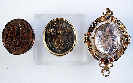
Mercury Press Agency / The Daily Telegraph, UK
The team has recovered artefacts off the Anglesey coast that suggest the ship could have been carrying gold and supplies from the King of France.
One of the items found on the seabed was a rare ring seal of Mary Queen of Scots, which was recovered in the 1980s but only recently examined to confirm its identity.
Historians say it is likely that it would have been carried as proof of the intentions of the crew.
The Prince – Charles Edward Stuart – was at the time in hiding after the failure of the Jacobite Rebellion and his defeat at the hands of the Hanoverian forces.”
[Full Story]
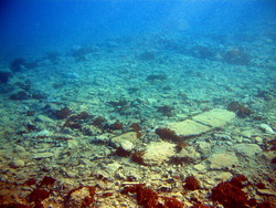
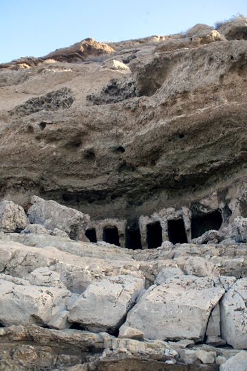
“Ship Over 2,000 Years Old Found in Novalja”
May 25, 2009, Javno, Croatia:
“In Novalja, an ancient sewn ship over 2000 years old was found. The excavations will last around two years.
A diver explores dead coral reefs off Gili Trawangan island, north of Lombok island
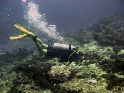
Javno, Croatia
In the Caska Bay on the Island of Pag, near Novalja, an ancient sewn ship over 2,000 years old was found. This is the result of research done by the city of Novalja and the Zadar University, in cooperation with the French institute for scientific research (CNRS-CCJ University in Marseille) and numerous other foreign associates.
Archaeologists have found a ancient sewn ship more than 2000 years old in Pag’s Caska Bay, reports ezadar.hr.
‘In Roman times, Novalja was known for its port accommodation and was located on the old sea route from Greece to northern Italy and central Europe. The ships would wait in Novalja for suitable winds and because of that a town developed there that had various suitable servces. Today there are numerous remains of Roman architecture under the whole region, like water supply lines, well equipped basilicas, graves’ said Brusic for ezadar.hr.
At the bottom of the bay there is the sunken Roman town named Kissa (Cissa), whose remains are being researched, and the discovery of the sewn ancient ship was the result of the joint work of around 20 Croatian and French archaeologists, added the professor.”
[Full Story]
“Gregg Stemm: is taking treasure from shipwrecks piracy?”
May 21, 2009, The Times, UK:
“He has made millions liberating treasure from shipwrecks, and is accused of bounty hunting. But Gregg Stemm says he is preserving history.
Gregg Stemm, Chairman of Odyssey Marine Exploration
Tim Bouquet for The Times, UK
These days the word conjures up images of audacious hijackings of container ships off the horn of Africa, but when, in October 2007, César Antonio Molina told reporters: ‘There have always been navies . . . to combat pirates’, Spain’s culture minister was referring not to Somali gangs but to the American entrepreneur Greg Stemm.
Stemm is probably the only ‘pirate’ to run a publicly quoted company, filing financial statements with the US Securities and Exchange Commission (SEC). These reveal that he earns $350,000 a year on top of his $6.14 million shareholding, and that his investors include the founder of Dollar Car Rental, a former Finance Minister of Bermuda and Barclays Global Investors.
A fusion of Jacques Cousteau, Ernest Hemingway and Donald Trump, the 52-year-old is Chairman of Odyssey Marine Exploration (OME), which specialises in finding treasure-laden wrecks. Stemm has the precise handshake and manners of a Southern gentleman, but when we meet in London he is itching to get back to his diesel-smelling dive ship Odyssey Explorer in Cornwall, and what he calls ‘mucking about on the ocean’.
And while he denies being a bounty hunter, he admits having no problem ‘marrying archaeology with a business model’“
[Full Story]
“Trawlers are destroying historic wrecks, say explorers”
May 20, 2009, The Times, UK:
“The wreck of HMS Victory, a British warship sunk in the English Channel in 1744, is being destroyed by fishing trawlers, according to the American treasure hunters who discovered the site last year.
‘We were shocked and surprised by the degree of damage we found in the Channel’, said Greg Stemm, chief executive of Odyssey Marine Exploration.
‘When we got into this business, like everyone else we thought that beyond 50 or 60 metres, below the reach of divers, we’d find pristine shipwrecks. We thought we’d be finding rainforest, but instead found an industrial site criss-crossed by bulldozers and trucks.’
Odyssey — the world’s only publicly-listed shipwreck exploration company — surveyed 4,725 sq miles (12,300 sq km) of the western Channel during its search for high-value shipwrecks.
It discovered 267 wrecks, of which 112, or 41 per cent, show evidence of damage from a type of fishing known as bottom trawling.”
[Full Story]
“Mapping the world’s oldest submerged town'”
May 19, 2009, Nature, UK:
“Underwater archaeologist Jon Henderson is hoping to reveal the secrets of the ancient Greek town of Pavlopetri.
A few metres under the sea, near the town of Neapolis at the southern tip of Greece, lies Pavlopetri. Discovered and mapped in the 1960s, it will become the first underwater town to be digitally surveyed in three dimensions.
A building at Pavlopetri
Jon Henderson, Nature
Nature News caught up with Jon Henderson, an underwater archaeologist at the University of Nottingham, UK, before the project began on 18 May.
‘The site is submerged in about 3–4 metres of water, and covers an area of about 500 square metres, about 50-60 metres offshore.’.
‘There are about 15 buildings made up of three or four rooms, some streets, rock-cut tombs and courtyards — and there could be more underneath, because so far there has been no excavation. Some ruins date from at least 2800 BC, but we think the town Pavlopetri itself dates from the Mycenaean period, about 1600–1100 BC.’“
[Full Story]
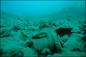
“Milwaukee man involved with historic shipwreck finds
in Albania and Sicily”
May 17, 2009, OnMilwaukee, USA:
“Over the past two summers, a research ship carrying US and Albanian experts has combed the waters off southern Albania inch by inch, using scanning equipment and submersible robots to seek ancient wrecks.
In what organizers say is the first archaeological survey of Albania’s seabed, at least five sites were located which could possibly fill in the blanks on ancient shipbuilding techniques.
Amphorae on the seabed off Albania
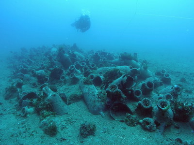
OnMilwaukee, USA
‘Albania is a tremendous untapped (archaeological) resource’, said US archaeologist Jeffrey G. Royal from the Key West, Florida-based RPM Nautical Foundation, a nonprofit group leading the underwater survey.
‘With what we’ve discovered until now, we may say that Albania is on a par with Italy and Greece.’“
[Full Story]
“Much of history lies below the surface”
May 15, 2009, Asahi Shimbun, Japan:
“Research of ruins on seabeds and in lakes or rivers is increasing in Japan, where many sites are yet to be fully explored.
In Kushimoto in Wakayama Prefecture, the U.S.-based Institute of Nautical Archaeology held an excavation survey January and February of the Ertugrul, a Turkish warship that went down off the coast during the Meiji Era (1868-1912).
Turkish salvagers remove the lid from the ship’s cooking pot
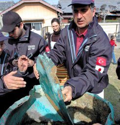
Asahi Shimbun
The 2,344-ton wooden battleship of the Ottoman Empire’s navy was on its return voyage after paying a courtesy call on Emperor Meiji in 1890 when the ship was caught in a storm, run aground and went down.
The survey team, led by Turkish archaeologist Tufan Turanli, consisted of members from Turkey, Spain and Japan. The survey began in fiscal 2006. This year, the team salvaged 3,513 items, including armaments, broken ceramic pieces, coins and a large cooking pot.
The Sone ruins at the bottom of Lake Suwako in Nagano Prefecture were discovered 100 years ago this year. Thousands of years ago, they were built on dry land.
The ruins in the lake date back about 10,000 years to the Paleolithic Age through the beginning of the Jomon Pottery Culture (c. 8000 B.C.-300 B.C.).
The ruins are likely to have been submerged when the level of Lake Suwako rose, starting in the early Jomon period,” Satoshi Tanaka, a municipal employee of the Suwa city government, said. Last year, he organized a special exhibition of the ruins.”
[Full Story]
“Race to preserve the world’s oldest submerged town”
May 12, 2009, PhysOrg, USA:
“The ancient town of Pavlopetri lies in three to four metres of water just off the coast of southern Laconia in Greece.
The ruins date from at least 2800 BC through to intact buildings, courtyards, streets, chamber tombs and some thirty-seven cist graves which are thought to belong to the Mycenaean period (c.1680-1180 BC).
This Bronze Age phase of Greece provides the historical setting for much Ancient Greek literature and myth, including Homer’s Age of Heroes.
Underwater archaeologist Dr Jon Henderson, from The University of Nottingham, will be the first archaeologist to have official access to the site in 40 years.
The aim of Dr Henderson’s project is to discover the history and development of Pavlopetri, find out when it was occupied, what it was used for and through a systematic study of the geomorphology of the area establish why the town disappeared under the sea.”
[Full Story]
“Viking ship found on Swedish lake bottom”
May 09, 2009, MarketWatch, USA:
“Divers stumbled on the wreck of a Viking ship this week on the bottom of the largest lake in Sweden.
Archaeologists say the ship is the first from the Viking era found underwater in Sweden, The Local reported. Previous Viking ship discoveries have been used for land burials.
The boat was in the midst of an island group in the center of Lake Vanern. Most of the wreck was covered with 3 feet of mud with a single rib sticking out of the ooze, the divers said.”
[Full Story]
“Expert Says Satellite Images from Space
Reveal Sunken Treasure Ships”
April 29, 2009, Salem-News, USA:
“Master Merchant Marine and salvage consultant, Captain Tom Williams pens tense tale of lost sunken treasure and asks the forbidden questions: how are all the lost and ancient shipwreck sites suddenly being found?
And should any international laws apply to deep water salvage?
Odyssey, a deep-sea exploration team based in Tampa Florida announced in May 2007 that they had found the shipwreck of a Spanish Galleon.
The ‘Nuestra Senora de las Mercedes y las Animas’ which sank near the Portuguese coast in 1804, has reportedly yielded 17 tons of salvaged silver from the Atlantic Ocean seafloor.
The British warship HMS Victory was reported found by the same Odyssey group in February 2009, after sinking with all hands in 1744.
This lost shipwreck is expected to yield 4 tons of gold from 330 feet below the English Channel.
Can the recent find of the Spanish Galleon worth 500 million, and HMS Victory with four tons of gold onboard be linked to a new and highly secret technology? Have all the other lost treasure ships around the world already been found by an orbiting satellite?
Could the price of precious metals plummet if suddenly every lost treasure ship undiscovered for centuries was available for instant salvage?”
[Full Story]
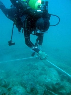
“Wreck diving in maritime archaeological sites in
basses reef in Sri Lanka”
April 20, 2009, Sri Lanka Navy, Sri Lanka:
“During the recent past number of Maritime Archaeology Projects were launched by Archaeology Department and Central Cultural Fund (CCF) of Sri Lanka. Most of these projects were funded by UNESCO.
Even though, Archaeology Department of Sri Lanka has few divers (some are qualified others not) at Maritime Archaeology Unit, Galle, Sri Lanka Navy (SLN) has provided support in terms of divers, boats, diving equipments in big way in all successful underwater archaeology projects.
Until the Lighthouses were established by Imperial Lighthouse Service of UK in 1870, on this deadly reefs away from Sri Lankan main land, number of ships ran aground and perished. Archaeology Department of Sri Lanka has found difficult to protect these valuable maritime Archaeological site due to the simple reason that they do not have sufficient maritime resources (boats and diving equipments) and personnel to protect them.
The Dutch-origin wooden ship wreck (ship carrying brass bricks) which is situated in
little basses reef also under threat from treasure hunters. The pictures taken
during inspection dive few weeks back. Propeller and shaft of
the decayed wooden ship which carried copper bricks
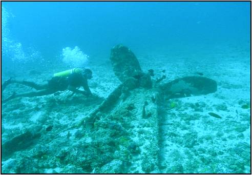
Sri Lanka Navy
Now, the Sri Lanka Navy is playing major role in protecting these sites. Our waters in Sri Lanka have a rich repository of cultural heritage. These forgotten treasures are vital to understanding our world history, in particular how people interacted economically and culturally in the past.
Godawaya, the village south of Ambalantota, where Walawe river falls in to sea few centuries ago (now the river has changed its flow and falls in to the sea at Ambalantota) is a historic site. The findings and excavations at ruins of ancient harbour and stone pillared dock will bring new light to the Sri Lankan Maritime Heritage.
Recovering sample of clay pot
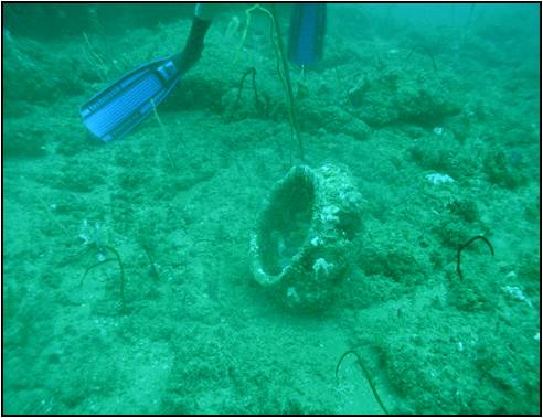
Sri Lanka Navy
Following action implemented to protect these historic shipwreck sites under Naval Supervision. Local Police and Archaeological Department were informed that SLN approval is required for any diving expedition in Basses reefs.
Supervising of diving expeditions will be done by retired SLN divers, who are well trained and experience. These wrecks are graves of gallant sailors who sailed in our waters and who perished with their ships; whatever the nationalities they are. Therefore we have a moral obligation to protect these graves from treasure hunters, who disturb and damage these graves.”
[Full Story]
“Archeologists dive the Charleston Harbor”
April 17, 2009, WCBD News, USA:
“Jim Spirek, and his team of archeologists from the University of South Carolina, geared up to dive into the harbor in search of civil war shipwrecks.
The purpose of the underwater investegation, to interpret and preserve the charleston harbor naval battlefield, gaining a clearer picture of battles that took place. Spirek and his archaeological team hope to give us new insight on the shipwrecks that litter our harbor.
‘right now we are over the site of the USS Patapsco a Union Ironclad that was sunk in janurary 18 1865’.
Spirek says they have no plans for excavation due to the size of the job, unlike the hunnely, the Patapsco is scattered throughout the harbor”
[Full Story]
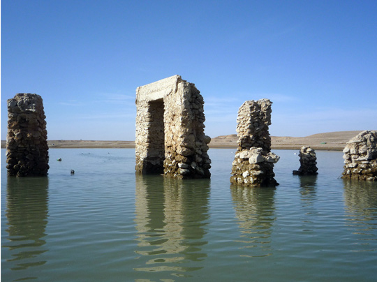
“Graverobbers feared as lake reveals Iraqi history”
April 06, 2009, Reuters, UK:
“Drought and dams have vastly shrunk a lake in Iraq’s western Anbar province, revealing ancient dwellings and burial sites that archaeologists fear will now be targeted by thieves.
‘We found recently opened graves with destroyed grave items around. We found some bones scattered nearby. Some of this is due to the water, but this was also due to recent activity’, said Yassin Jbara, an archaeologist supervising Haditha sites.
Recently broken ancient jars lie scattered on the lake’s banks, where an eerie forest of skeletal trees have re-emerged from water that flooded the area in 1986 when a dam was built.
Dams further up the Euphrates river and drought have vastly dried the lake over the past two years. Now the dead trees stand stark against the bleak desert landscape, and decaying birds sway in the fishing nets tangled in the tree tops.
‘There are people that dig up these pots and break them open looking for gold’, said Jbara, plucking pottery from the mud.
Looting of the country’s ancient sites has been a common problem in the decades of war and sanctions under Saddam Hussein and the lawlessness that engulfed Iraq since he fell in 2003, when looters carted off 15,000 artifacts just from the museum.”
[Full Story]
“Treasure trove of artifacts recovered from
Blackbeards 18th-century ship”
April 01, 2009, GroundViews, Sri Lanka:
“Archaeologists have recovered a treasure trove of artifacts from a recently recovered ship of the infamous 18th-century pirate Blackbeard.
According to a report in the National Geographic News, some of the newfound relics add to evidence that the ship belonged to the pirate.
We feel pretty comfortable that thats what this is, said Marke Wilde-Ramsing, director of the Queen Annes Revenge project for the North Carolina Office of State Archaeology.
Underwater archaeologists from the North Carolina Department of Cultural Resources have been excavating the wreck, which lies 22 feet (7 meters) underwater a few miles off Beaufort, North Carolina, since 1997.
Among the discovered artifacts is a brass navigational instrument known as a chart divider.
Navigational instruments were favorite targets of looting pirates, because the tools could easily be sold or traded, according to archaeologist David Moore of the North Carolina Maritime Museum, who is working on the wreck site.”
[Full Story]
“Discovered: A sunken island, an Indian Ocean Atlantis?”
April 01, 2009, GroundViews, Sri Lanka:
“Marine archaeologists have just discovered evidence of a large submerged landmass southeast of Sri Lanka. They believe it could be a legendary lost island closely linked to the culture and history of Sri Lankan people.
The discovery was made by a team of Dutch and Sri Lankan scientists based on satellite maps and underwater sample extractions from the deep sea.
Preliminary data need to be verified by a deep sea submersible expedition during 2009 – 2010, according to a member of the research team who did not want to be identified.
The landmass is estimated to be between 450,000 and 475,000 square kilometres, which is about seven times the total land area of Sri Lanka.
‘This could well be the long lost island of Irisiyawa, which is euphemistically mentioned in our chronicles and hinted at in the writings of Greek historians’, said Dr Godwin Samarawickrama, a maritime historian at the Indian Ocean Institute based in Melacca, Malaysia.
He added: ‘The existence of such an island has been speculated and talked in hush-hush terms among divers and archaeologists for decades. This is the Indian Ocean’s own version of Atlantis!’
Irisiyawa’s existence is first mentioned in the Sri Lankan chronicle of Culavamsa. Sinhalese Sandesa (message poem) writers in the 14th to 16th centuries often refer to the enormous psychological effect by sunken Irisiyawa on royal families, aristocracy and ordinary people.
Some say the legacy of Irisiyawa has continued well into the twenty first century.
Other experts are more sceptical, and point out long-standing speculations about Kumari Kandam, a legendary sunken landmass said to have been located to the south of present-day Kanyakumari District at the southern tip of India.
Some also call it Lemuria, a continent that existed in ancient times and sank beneath the ocean as a result of a geological, often cataclysmic, change. There is no scientific evidence to support these claims.”
[Full Story]
“Drought Reveals Iraqi Archaeological Treasures”
March 24, 2009, NPR, USA:
“Iraq is suffering one of the worst droughts in decades. While this is bad news for farmers, it is good news for archaeologists in the country.
The receding waters of the Euphrates River have revealed ancient archaeological sites, some of which were unknown until now.
Ancient buildings have emerged from the river bed in Iraq’s western Anbar province as the Euphrates River dries up. For the first time, archaeologists are able to access sites that had been flooded by Saddam Hussein in the mid-1980s.
Copyright © Ali Abbas for NPR
For Ratib Ali al-Kubaisi, the director of Anbar province’s Antiquities Department, the drought has opened up a whole new land of opportunity.
He explains that civilization began in Anbar, next to the Euphrates River. ‘Everyone … thought that Anbar was only desert with no historical importance. But we discovered that this area is one of the most important archaeological areas in all of Iraq. This part of Iraq was the first to be settled’, he says.
Cliffs that were once submerged now reveal pre-Christian tombs built into the rock face
Ali Abbas for NPR
In the mid-1980s, Saddam Hussein’s government dammed the Euphrates in the area, flooding a 120-mile-long stretch of land near Iraq’s border with Syria. What once was an enormous reservoir that stretched as far as the eye could see has shrunk an astonishing 90 percent since summer, officials say.
Ratib says that at least 75 archeological sites had been partially excavated before the area was flooded. They ran the gamut of civilizations — from 3,000 B.C. to the Sumerian and Roman periods. Ancient Jewish settlements were also submerged in the area.
But because of the receding waters, Ratib has been able to access some sites for the first time — including, for instance, a cliff with a series of pre-Christian tombs carved into its face.”
[Full Story]
“Greek fisherman nets 2,200-year-old bronze statue”
March 23, 2009, The News & Observer/AP, USA:
“A Greek fisherman must have been expecting a monster of a catch when he brought up his nets in the Aegean Sea last week.
Instead, Greek authorities say his haul was a section of a 2,200-year-old bronze statue of a horseman.
In this handout photo provided by the Greek Ministry of Culture on Monday, March 23, 2009, the torso and raised right arm of a 2,200-year-old statue are seen
after it was raised in a fisherman’s nets
Greek Ministry of Cunture/AP
A Culture Ministry announcement said Monday the accidental find was made in waters between the eastern islands of Kos and Kalymnos.
The fisherman handed over the corroded metal figure to authorities, who have started the cleaning process.”
[Full Story]
“China to salvage 400-year-old merchant vessel
off southern coast”
March 11, 2009, XinhuaNet, China:
“Chinese archaeologists will start later this year to salvage a ship thought to be a Ming Dynasty merchant vessel that sank off the Guangdong coast 400 years ago, the State Administration of Cultural Heritage (SACH) said Wednesday.
The SACH approved the excavation plan early this year, it said in a statement to Xinhua. The administration hasn’t yet announced all details of the salvage plan, but the Guangdong provincial cultural heritage department will organize an excavation team, the statement said.
The 10-meter-long ship was found buried in the silt on the sea floor, about 5.6 nautical miles offshore from Shantou City, Guangdong Province.
About 200 pieces of porcelain were recovered when the ship was found in 2007. The ship could have been carrying some 10,000 pieces of porcelain, most made during the reign of Emperor Wanli of the Ming Dynasty (1573-1620). However, the earliest piece found so far dated back to the Song Dynasty (960-1279).
The ship was probably a Guangdong merchant vessel, since most of the porcelain items found so far were produced by local workshops, said Cui Yong, an archaeologist with the Guangdong Provincial Institute of Archaeology and Relics.”
[Full Story]
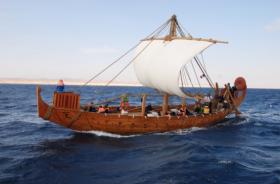
“Sail Like An Egyptian:
It turns out the oldest seafaring ships ever found actually work”
March 10, 2009, Popular Science, USA:
“An archaeologist who examined remnants of the oldest-known seafaring ships has now put ancient Egyptian technology to the test.
A stone relief from Hatshepsut’s temple shows the quarter rudder of an ancient Egyptian Punt ship. Archaeologists and ship designers based their replica ship design on historical
images as well as artifacts from the caves at Wadi Gawasis
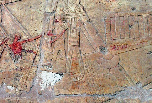
C. Ward for Popular Science
She teamed up with a naval architect, modern shipwrights and an on-site Egyptian archaeologist to build a replica 3,800-year-old ship for a Red Sea trial run this past December.
The voyage was meant to retrace an ancient voyage that the female pharaoh Hatsheput sponsored to a place which ancient Egyptians called God’s land, or Punt. Ship planks and oar blades discovered in 2006 at the caves of Wadi Gawasis provided a basis for the ship reconstruction.
Naval architect Patrick Couser based the design of Min of the Desert on the ship components found at Wadi Gawasis, as well as the dimensions of an ancient Egyptian “Dashur” boat.
By doubling the dimensions and curvature of the “Dashur” boat, Couser produced
a design that fit the profile of the Punt ships in Hatshepsut’s temple.
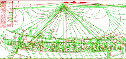
Patrick Couser
‘The planks that we looked at from the archaeological site are in great condition’, said Cheryl Ward, the maritime archaeologist at Florida State University who headed the effort.”
[Full Story]
“Maritime Archaeologist at Helm of Modern Journey
to Ancient Egyptian Land”
March 07, 2009, PhysOrg, USA:
“Ancient Egyptians may be best known for building pyramids, but internationally renowned maritime archaeologist Cheryl Ward wants the world to know that they were pretty good sailors, too.
Min is 20 meters (66 feet) long and could have carried a cargo of about 15 tons
in addition to crew and supplies. The modern reconstruction was
built in only six months at an Egyptian shipyard
PhysOrg, USA
She ought to know. Ward, an associate professor of anthropology at The Florida State University, and an international team of archaeologists, shipwrights and sailors recently built a full-scale replica of a 3,800-year-old ship and sailed it on the Red Sea to re-create a voyage to a place the ancient Egyptians called God’s Land, or Punt.
Their expedition was financed and filmed as part of a French documentary that will air internationally and on an upcoming episode of ‘Nova’.
‘This project has demonstrated the extraordinary capability of the Egyptians at sea’, Ward said.
‘Many people, including my fellow archaeologists, think of the Egyptians as tied to the Nile River and lacking in the ability to go to sea. For 25 years, my research has been dedicated to showing the scope of their ability and now, to proving their independently invented approach to ship construction worked magnificently at sea’.”
[Full Story]
“Bronze Age Discovery Mirrors Modern Era”
March 02, 2009, MSNBC News, USA:
“Ten parts copper, one part tin. It sounds like a simple equation, but the discovery of this formula — the essential proportions of bronze metal — set in motion world-changing events, forever altering life on our planet by ushering in the modern era of metalworking, mechanical invention and more.
The questions of exactly when, where and how the Bronze Age actually began remain unanswered, lost in time — archeologists date the era somewhere between 3300 and 1100 B.C.
But an exhibit underway at New York’s Metropolitan Museum of Art offers a revelation as to why the discovery of bronze alchemy helped to unite and elevate the disparate mud-walled kingdoms of that time, literally forging civilization as we know it today.
The exhibit centers around a shipwreck found in the Mediterranean Sea off Uluburun on the coast of Anatolia, or what is now Turkey.
Among the artifacts recovered from the ship, a trading vessel dating from the late 13th century B.C., were two consignments of metal — 10 tons of copper and one ton of tin.
According to one reviewer, the exhibit illustrates ‘how the Bronze Age could only have existed through the combining of two raw materials found in geographic locations far apart — tin from Afghanistan and copper from Turkey.’“
[Full Story]
“Submerged ancient Thracian city to see daylight in Bulgaria”
February 25, 2009, The Earth Times, UK:
“Discovered under centuries-old layers of dirt in 1948, then submerged under 20 metres of water, the ancient city of Seuthopolis is to emerge once again in a bold rescue project.
The magnificently preserved city, founded by the Thracian king Seuthes III in 323 BC, was discovered in central Bulgaria during the construction of a dam on the Tundzha river.
Despite the stunning discovery, Communist authorities went ahead with the dam and created the Koprinka reservoir six years later, in 1954, flooding Seuthopolis under 150 million cubic metres of water.
Now, a 150-million-euro (192-million-dollar) project by Bulgarian architect Jeko Tilev aims to right the wrong and expose the polis at the bottom of the reservoir to archaeologists and tourist by creating a dry well 20 metres deep and 420 metres across.
Once in place, the 1.27-kilometre wall, effectively a round pier, would allow further exploration and the reconstruction of five hectares now at the bottom of the reservoir, 160 kilometres east of Sofia near Kazanlak.”
[Full Story]
“Trawlers are ‘destroying history on the seabed'”
February 22, 2009, The Observer, UK:
“Britain’s love of seafood is helping to destroy the nation’s maritime heritage.
That is the stark warning of marine archaeologists who say hundreds of sunken ships, from Elizabethan warships to second world war submarines, are being torn apart by trawlers – fishing for scallops and flatfish – dragging chains and cables across the seabed.
Investigations using robot submarines have revealed that serious damage has been inflicted on vast numbers of the 32,000 pre-1945 ships whose wrecks litter Britain’s coastal waters.
Examples include the recently discovered 18th-century warship HMS Victory, which led Britain’s fleet before Nelson’s flagship of the same name.
In 1744, Victory sank with all hands near the Channel Islands. Cannon hauled from the wreck showed it had suffered severe damage from trawlers.”
[Full Story]
“Sunken Greek treasures at risk from scuba looters”
February 22, 2009, ABC News/Reuters, Australia:
“A corroded mechanism recovered by sponge divers from a sunken wreck near the Greek island of Antikythera in 1902 changed the study of the ancient world forever.
The Antikythera Mechanism, a system of bronze gears from the 2nd century BC, was used to calculate the date of the Olympic Games based on the summer solstice.
The 5th Century bronze statue of Poseidon now stands in Greece’s National
Archaeological Museum after being salvaged from the sea
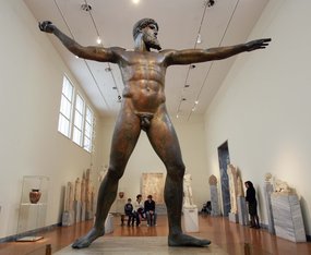
John Kolesidis/Reuters
Its mechanical complexity was unequalled for 1,000 years, until the cathedral clocks of the Middle Ages.
Archaeologists believe hundreds more wrecks beneath the eastern Mediterranean may contain treasures, but a new law opening Greece’s coastline to scuba diving has experts worried that priceless artefacts could disappear into the hands of treasure hunters.
‘The future of archaeology in this part of the world is in the sea’, said marine archaeologist Harry Tzalas. ‘This law is very dangerous, it opens the way to the looting of antiquities from the seabed, which we don’t even know exist.’“
[Full Story]
“Libyan excavations have added depth to modern archaeology”
February 22, 2009, Business Daily Africa, Kenya:
“The French writer Jean-Marie Blas de Roblès tells how he pursued his dream of uncovering ‘fragments of raw beauty long since forgotten’ from the depths of the sea, an emotional experience very different from a treasure hunt.
Between 1986 and 2001, the novelist took part in underwater archaeological excavations off the coast of Libya, exploring that ‘unseen part of ourselves’ which must be carefully and respectfully protected.
According to Blas de Robles, underwater archaeology is no different from terrestrial archaeology; they use similar techniques even if underwater excavations are more complicated to undertake and require special equipment and even specific skills
Business Daily Africa, Kenya
It all began in 1985. Not long returned from his first terrestrial dig with the French archaeological mission in Libya — one of the privileges of friendship — Claude Sintes [Director of the Museum of Ancient Arles] wasted no time in sharing his experiences with me: coming from Apollonia, he had seen Cyrene, Sabratha and Leptis Magna — Greek and Roman remains surpassing in size everything we knew or could have imagined.
He said he had no idea that whole towns lay buried under the sand of the seashore in such wondrous and magnificent settings.
But even better was the fact that hardly anyone had ever thought of exploring the seabed off this coastline. Everything was still exactly where it had been in the seventh century BC! Imagine the fabulous finds there might be! “
[Full Story]
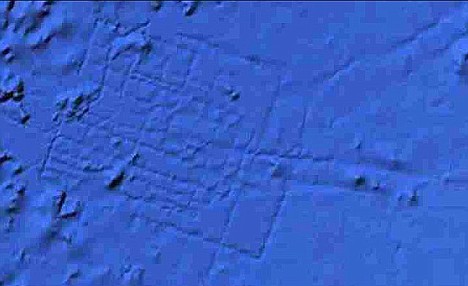
“Google dismisses ‘Atlantis find'”
February 21, 2009, BBC Science News, UK:
“The Lost City of Atlantis is still lost – despite hopes that Google Earth had located the fabled city on the floor of the Atlantic Ocean.
Observers noted what seemed to be a grid of streets and the outlines of a big city on the sea floor about 960km (600 miles) off the African coast.
However close you look, this is not the Lost City of Atlantis
Google Earth/BBC Science News
Experts had said this was one of the possible sites of the city described by Plato, the Greek philosopher.
But Google said the lines represented sonar data collected from boats.”
[Full Story]
“Google Earth’s ocean tool has spotted
the mythical city of Atlantis?”
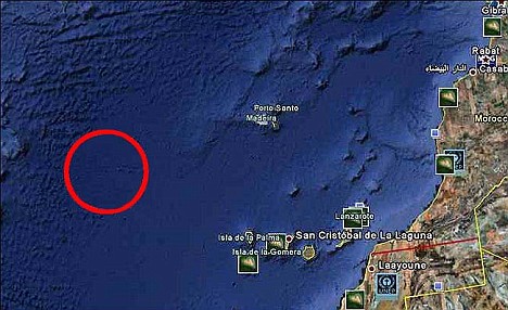
February 21, 2009, Top News, USA:
“What, Google Earth has spotted the mythical city of Atlantis? Is it really the city lost under the sea, which Google Earth’s new underwater search tool has found?
Well, Bernie Bamford, a British aeronautical engineer has claimed that he has spotted a mysterious grid of undersea lines while using the Google Earth’s new underwater search tool
However close you look, this is not the Lost City of Atlantis

Top News, USA
Bamford exacted that he spotted the strange pattern off the western coast of Africa, evidently near one of the possible sites of the legendary island, Atlantis, described by Greek philosopher Plato.
The screenshots from Google Earth displaying what appears like a city street grid on the ocean floor west of Morocco, in an area known as the Madeira Abyssal plane, were published by the London’s tabloid The Sun, on Friday.
However, Google has waved off Bamford’s findings, saying that the undersea grid lines spotted by Bamford are data artifacts rather than sunken streets; the strange pattern could be linked to the fabled sunken city.
Google explained that ‘Bathymetric, or sea floor terrain, data is often collected from boats using sonar to take measurements of the sea floor. The lines reflect the path of the boat as it gathers the data’“
[Full Story]
“Hopes dashed as Google Ocean image of ‘lost city of Atlantis’ proves to be nothing of the sort”
February 20, 2009, The Daily Mail, UK:
“It was the picture that led many to believe that the mythical lost city of Atlantis had finally been discovered, more than 9000 years after it sank beneath the ocean’s waves.
An amazing photo taken using Google’s latest gadget, Google Ocean, appeared to show a grid system etched onto the ocean bed about 620 miles off the west coast of Africa.
Lost city: Could these grid-like markings show the location of
the lost city of Atlantis?
Google Ocean/Daily Mail:
But today a Google spokesperson cruelly dashed the hopes of scholars and romantics alike by ruling out the possibility that the lines were the remnants of an ancient civilization.
Sadly, the mysterious criss-crossing lines were explained away as sonar data collected as boats mapped the ocean floor.
The grid system was found in an area known as the Madeira Abyssal Plane
off the coast of Morocco, not far from the Canary Islands
Google Earth/Daily Mail:
The perfect rectangle was first noticed on Google’s new underwater exploration tool by a British aeronautical engineer who claims it looks like a ‘man-made aerial map’ of a city.
Atlantis experts said that the unexplained grid is located at one of the possible sites of the legendary island, which was first described by the ancient Greek philosopher Plato.
A spokeswoman said: ‘It’s true that many amazing discoveries have been made in Google Earth including a pristine forest in Mozambique that is home to previously unknown species and the remains of an Ancient Roman villa. In this case, however, what users are seeing is an artefact of the data collection process. The lines reflect the path of the boat as it gathers the data.’“
[Full Story]
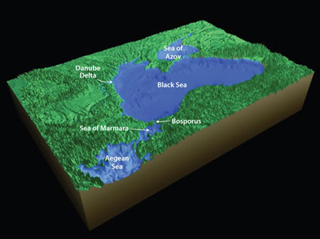
“Ancient Black Sea Flood: Nuisance or Calamity?”
February 19, 2009, Discovery Channel News, USA:
“Something happened along the shores of the Black Sea about 9,500 years ago. According to one theory, a huge flood suddenly drowned the landscape, forcing some of the planet’s first farmers to move elsewhere.
A new study paints a different picture.
The Black Sea
Discovery Channel News
‘I would say there was never a big flood’, said Liviu Giosan, a geologist at Woods Hole Oceanographic Institute in Cape Cod, Mass., and lead author of the study. ‘What we showed was that it’s impossible.’
The new work fuels an ongoing debate about the geologic history of the Black Sea. Research there has lagged behind other parts of the world, and many questions remain about how water levels have fluctuated over the years.
It’s a unique place. The Black Sea is an inland sea, surrounded by Turkey, Georgia, Russia, Ukraine, Romania and Bulgaria. It was once a freshwater lake surrounded by rich and fertile plains.
But about 9,500 years ago, sea levels rose as the climate warmed, and saltwater poured in from the Mediterranean through the Sea of Marmara.
The fossil record clearly shows a shift from freshwater to saltwater species around that time. Whether the change happened gradually or dramatically, however, is something scientists are still debating.”
[Full Story]
“New funding for Little Salt Spring, Florida
underwater archeological site”
February 19, 2009, EurekAlert, USA:
“The Gulf Coast Community Foundation of Venice has awarded the University of Miami (UM) $250,000 toward expansion of research and educational facilities at the underwater archeological and ecological preserve, Little Salt Spring (LSS), in North Port, Sarasota County, Florida.
The site is of enormous archeological and anthropological value due to its antiquity and exceptional preservation of ancient organic material.
Click the image below to watch a video of
the ongoing underwater reasearch at Little Salt Spring

EurekAlert, USA:
The gift was announced earlier this year, during a reception in Naples, Florida, to commemorate the 25th anniversary of the University’s exploration of the preserve. The site is a national archeological treasure, said Teri A. Hansen, president and CEO of Gulf Coast Community Foundation of Venice.
‘Little Salt Spring is arguably one of the most important archaeological sites in the country, and it’s right here in southern Sarasota County’, said Hansen.
‘By supporting the University of Miami’s work at the spring, we can help create a significant archaeological research facility in North Port while also providing public access and educational opportunities at this fascinating preserve.’
This unusual feature has allowed the preservation of a great deal of organic material deposited there thousands of years ago, explained John Gifford, associate professor at the Rosenstiel School of Marine and Atmospheric Science and principal investigator for the project.
‘”Little Salt Spring is unique in its ability to preserve prehistoric artifacts and organic matter,’ said Gifford.”
[Full Story]
“Mexico Refuses Permission for U.S. Firm
to Search Spanish Galleon”
February 18, 2009, LAHT, Venezuela:
“Mexican authorities rejected a request by U.S.-based Odyssey Marine Exploration to comb the wreck of a Spanish galleon that sank in 1631 in the Gulf of Mexico.
The National Anthropology and History Institute, or INAH, said in a communique that the two requests presented by Odyssey in 2006 and 2008 ‘do not meet the requirements that regulations establish for archaeological investigation in Mexico.’
INAH based its rejection of the request on the fact that U.S. firm ‘neither has the intention to do research nor the backing of archaeologists or of an academic institution of recognized prestige, conditions without which it is impossible to authorize this type of initiative.’
The institution explained that the two requests by Odyssey concerned the exploration of the Nuestra Señora del Juncal, a galleon that sank in the Bay of Campeche in 1631 and that has ‘always been in the sights of treasure hunters.’
The galleon was part of the Fleet of New Spain comprised of 19 royal vessels that set sail from Mexico for Spain on Oct. 14, 1631, loaded with precious goods.”
[Full Story]
“Mexico rejects US salvage firm request”
February 17, 2009, Press TV, Iran:
“Mexico has denied a US salvage company a permit to search for a sunken 17th century Spanish galleon off the country’s eastern shores.
Press TV, Iran
The proposal by treasure-hunting Odyssey Marine Exploration Inc. of Florida ‘is not intended to conduct research and does not have the approval of archaeologists or an academic institution of recognized prestige’, Mexico’s National Institute of Anthropology and History (INAH) said in a statement on Monday.
According to the statement, ‘treasure hunters have always had their eyes on’ the wreckage.
INAH legal adviser Maria Vilarreal explained that Mexico receives many search requests ‘that intend to recover important shipments for economic purposes … namely gold, silver and precious gems.’“
[Full Story]
“Egyptian treasures dazzle Turin”
February 12, 2009, ANSA, Italy:
“A stunning new exhibition has opened in Turin, showcasing gold, statues, jewels and lost treasures from ancient Egyptian cities lost beneath the waters of the Nile.
Exhibition showcases artefacts recovered from the Nile
ANSA, Italy
‘Egypt: Sunken Treasures’ hosts over 500 artefacts pulled from the riverbed and spanning a period of 1,500 years, from the 7th century BC to the 8th century AD.
The items were rescued from the lost cities of Herakleion and Canopus and submerged sections of Alexandria, by one of the world’s leading marine archaeologists, Franck Goddio of France, over a period of 15 years.
All three sites started a gradual descent into the Nile around 2000 years ago and are now submerged by around six metres of water.”
[Full Story]
“Cambodia Seeks Help To Bring Up Ancient Shipwreck”
February 11, 2009, Sin Chew Jit Poh, Malaysia:
“The Cambodian government has asked foreign partners to help bring up a centuries-old vessel discovered by divers off the southwestern coast in 2006, an official said Tuesday 10 February.
The project would be implemented in cooperation between the authority and the Institute of Arab and Islamic Studies of the British University of Exeter.
Head of the authority Abdullah Ba Wazeer said the project will involve excavations at the ancient Islamic cities and ports along the Yemeni coasts.
The operations will raise marine monuments and drowned ships in the country’s waters and those mentioned in historical references.”
[Full Story]
“Yemeni-British project to excavate marine monuments”
February 11, 2009, Saba Net, Yemen:
“The General Authority for Museums and Antiquities has revealed a Yemeni-British project is underway to excavate marine monuments.
The Yemen Coastline
Saba Net, Yemen
The project would be implemented in cooperation between the authority and the Institute of Arab and Islamic Studies of the British University of Exeter.
Head of the authority Abdullah Ba Wazeer said the project will involve excavations at the ancient Islamic cities and ports along the Yemeni coasts.
The operations will raise marine monuments and drowned ships in the country’s waters and those mentioned in historical references.”
[Full Story]
“Scientists Uncover a Dramatic Rise in Sea Level
and Its Broad Ramifications”
February 09, 2009, Smithsonian Press Release, USA:
“Scientists have found proof in Bermuda that the planet’s sea level was once more than 21 meters (70 feet) higher about 400,000 years ago than it is now. Their findings were published in the journal Quaternary Science Reviews Wednesday, Feb. 4.
Their findings were published in the journal Quaternary Science Reviews Wednesday, February 4.
Storrs Olson, research zoologist at the Smithsonian’s National Museum of Natural History, and geologist Paul Hearty of the Bald Head Island Conservancy discovered sedimentary and fossil evidence in the walls of a limestone quarry in Bermuda that documents a rise in sea level during an interglacial period of the Middle Pleistocene in excess of 21 meters above its current level.
Hearty and colleagues had published preliminary evidence of such a sea-level rise nearly a decade ago, which was met with skepticism among geologists. This marine fossil evidence now provides unequivocal evidence of the timing and extent of this event.
The nature of the sediments and fossil accumulation found by Olson and Hearty was not compatible with the deposits left by a tsunami but rather with the gradual, yet relatively rapid, increase in the volume of the planet’s ocean caused by melting ice sheets.”
[Full Story]
“Underwater stones puzzle archeologists”
February 08, 2009, Chicago Tribune, USA:
“Forty feet below the surface of Lake Michigan in Grand Traverse Bay, a mysterious pattern of stones can be seen rising from an otherwise sandy half-mile of lake floor.
Likely the stones are a natural feature. But the possibility they are not has piqued the interest of archeologists, native tribes and state officials since underwater archeologist Mark Holley found the site in 2007 during a survey of the lake bottom.
Underwater archeologist Mark Holley investigates a circle of stones on the Grand
Traverse Bay floor near Traverse City, Mich. Scientists are not sure
whether the stones were arranged by humans or natural forces
Chris Doyal/Chicago Tribune
The site recently has become something of an Internet sensation, thanks to a blogger who noticed an archeological paper on the topic and described the stones as ‘underwater Stonehenge’.
At the time of her sinking in 1744, the Victory was the most powerful warship in the world and was the immediate predecessor of Nelson’s flagship now berthed at Portsmouth.
Though the stones could signal an ancient shoreline or a glacial formation, their striking geometric alignment raises the possibility of human involvement. The submerged site was tundra when humans of the hunter-gatherer era roamed it 6,000 to 9,000 years ago.
Could the stones have come from a massive fishing weir laid across a long-gone river? Could they mark a ceremonial site? “
[Full Story]
“Sunken relics promise to unlock the secret of
how Victory met her doom”
February 07, 2009, The Times, UK:
“With its thruster motors fighting the current, the submersible pushed through a blizzard of sediment. Far above, in a darkened control room, the robot’s operator squeezed his eyes shut to push away the fatigue.
Making three dives a day, he had lost count of how many times he had approached suspected wrecks only to find a clump of ferrous rocks or junk from a ship. This time it would be different.
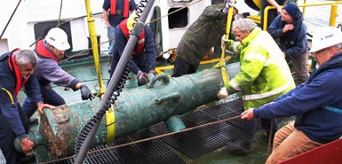
a canon retrieved from the wreck of HMS Victory
The Times, UK
The announcement this week that Odyssey Marine Exploration, the world’s biggest commercial shipwreck exploration specialist, has discovered what appear to be the remains of HMS Victory has caused a sensation.
At the time of her sinking in 1744, the Victory was the most powerful warship in the world and was the immediate predecessor of Nelson’s flagship now berthed at Portsmouth.
The 240ft Odyssey Alert had towed high-frequency sonar and sophisticated metal detectors across the search area, identifying anything that did not appear to be natural. Odyssey Marine had surveyed about 4,700 sq miles (12,170 sq km) of ocean floor in the Western Approaches of the English Channel alone. Then the 251ft Odyssey Explorer arrived with the robot Zeus to take a closer look with cameras.
About 270 wrecks had been found so far, but on paper this latest target did not appear to be important. Then, into the glare of Zeus’s halogen lamps, loomed a huge bronze cannon.
‘It was pretty amazing’, said Greg Stemm, Odyssey’s chief executive. ‘We knew the Victory was out there somewhere, but we were expecting this 110-gun ship to look huge — but it was a tiny reading. We almost missed it.’“
[Full Story]
“‘Noah’s Flood’ Not Rooted in Reality, After All?”
February 06, 2009, National Geographic News, USA:
“The ancient flood that some scientists think gave rise to the Noah story may not have been quite so biblical in proportion, a new study says.
Researchers generally agree that, during a warming period about 9,400 years ago, an onrush of seawater from the Mediterranean spurred a connection with the Black Sea, then a largely freshwater lake. That flood turned the lake into a rapidly rising sea. (See a map of the region)
A previous theory said the Black Sea rose up to 195 feet (60 meters), possibly burying villages and spawning the tale of Noah’s flood and other inundation folklore.
But the new study—largely focused on relatively undisturbed underwater fossils—suggests a rise of no more than 30 feet (10 meters).
Marine geologist Liviu Giosan and colleagues carbon-dated the shells of pristine mollusk fossils, which the researchers say bear no evidence of epic flooding.
Found in sediment samples taken from where the Black Sea meets the Danube River, the shells ‘weren’t eroded, agitated, or moved’, said Giosan, of the Woods Hole Oceanographic Institute in Massachusetts. ‘We know the mud is exactly the same age as the shells and so can determine what the sea level was about 9,400 years ago.’“
[Full Story]
“‘Secrecy Is Key in Our Business'”
February 03, 2009, Spiegel Online, Germany:
“The underwater archaeology company Odyssey Marine Exploration recently found the British warship HMS Victory on the floor of the English Channel.
Spiegel Online spoke with company founder Gregg Stemm about gold coins, recalcitrant governments and secrecy.
SPIEGEL ONLINE: You have said that your find of the HMS Victory is the most significant shipwreck find to date. How long had you been looking for it?
GREG STEMM: We have been working on the Atlas mapping project in the English Channel for four years now. We are searching an area of about 5,000 square miles (12,950 square kilometers), and in the course we have turned up a total of 273 shipwrecks, including some previously unidentified U-Boats — and the HMS Victory.
SPIEGEL ONLINE: You stumbled across the HMS Victory by chance?
GREG STEMM: We knew it was in the search area, so it was not by chance. We were always very aware of the possibility that it could happen. But we did not specifically look for it, unlike in the case of HMS Sussex in 2001.”
[Read The Full Interview]
“Wreck of original HMS Victory found”
February 03, 2009, Yachting Monthly, UK:
“The ship which inspired Nelson’s Victory, HMS Victory lost in 1744, has been found, solving one of the greatest mysteries in naval history.
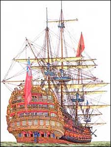
Yachting Monthly, UK
The direct predecessor and inspiration behind Nelson’s flagship, Balchin’s Victory was the mightiest and technically most advanced vessel of her age. She sank during a storm in 1744 with all hands and was the last Royal Navy warship to be lost at sea with a complete complement of bronze cannon.
Two of the greatest admirals in English history, Sir John Norris and Sir John Balchin, called her their flagship. Research indicates that Balchin’s Victory sank with a substantial amount of gold and silver specie aboard.
‘Finding this shipwreck has solved one of the greatest shipwreck mysteries in history. Having discovered it in deep water far from where history says it was lost has served to exonerate Admiral Balchin and his officers from the accusation of having let the ship run aground on the Casquets due to faulty navigation’, commented Greg Stemm, Odyssey’s Chief Executive Officer.
‘We have worked closely with the MOD on this operation, and anticipate that we will continue the excellent cooperative relationship that we have enjoyed working together on the Sussex project. Fortunately, this shipwreck is not in waters claimed by any other country, so we do not expect any interference in further exploration of the site.’“
[Full Story]
“300 feet below, a lost treasure is found”
February 02, 2009, Miami Herald, USA:
“U.S. salvagers announced Monday that they have located the wreckage of the HMS Victory, one of the most important ships in British naval history, which sank in 1744 carrying four tons of gold coins.
Generations of researchers have puzzled over the loss of the Victory, a predecessor of the HMS Victory that was the flagship of Adm. Horatio Nelson, hero of the 1805 Battle of Trafalgar.
The ship, the most modern in the British fleet at the time, was lost with a crew of more than 1,000, more than 100 brass cannons and 100,000 gold coins it was transporting from Portugal.
Most historians have said the wreckage had to lie close to the Channel Islands, south of England and near the French coast, where the ship’s captain, Adm. John Balchin, was believed to have fatally steered it onto rocky shoals.”
[Full Story]
“Rising seas increased carbon intake”
January 30, 2009, Planet Earth Online, UK:
“Rising sea levels since the last ice age have significantly increased the oceans’ capacity to absorb CO2, according to new research.
Model visualisations of the growth of the northwest European shelf seas
between the last ice age (22,000 years ago) and today
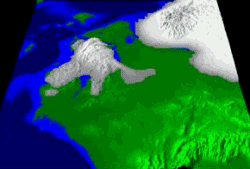
Planet Earth Online
Global sea levels have risen some 130 metres since the height of the last ice age as glaciers and icecaps have melted. This flooded vast areas of land, equivalent to around twice the area of the USA, and increased the area of shallow ‘continental shelf’ sea by around 400 per cent.
The shallow bodies of water formed as the waters rose, such as the North Sea, can support large algal blooms each summer particularly in regions subject to thermal stratification – this is when the water column becomes separated into distinct layers of warm and cold water.
Researchers at the universities of Bangor and Kyushu have calculated that the increase in stratified conditions has greatly increased the total amount of carbon absorbed by the oceans.
The researchers combined sophisticated tidal models with reconstructions of past landscapes to simulate the effect on CO2 absorption from growth of continental shelf seas in the 22,000 years since the height of the last ice age.”
[Full Story]
[This sequence showing just how much of the the Ice Age landmass was flooded over the past 13,000 years or so gives a good idea of where marine archaeologists should look for evidence of human occupation and civilisation during the last Ice Age – Ed.]
“Divers plunder Greece’s sunken treasure troves”
January 30, 2009, The Guardian, UK:
“For centuries they have lain forgotten and untouched in the murky depths of the Mediterranean. But the sunken glories of Greece are now threatened by modern treasure hunters, who are targeting their riches since the lifting of a ban on coastal scuba-diving.
A Greek amphora, part of a long-lost cargo
Jeffrey L Rotman/Corbis
At risk, say archaeologists, is an unseen part of the country’s cultural patrimony, comprising thousands of shipwrecks dating from Classical, Hellenic, Roman, Byzantine and early modern times and their priceless cargoes of coins, ingots, weapons and gold.
‘Greek waters are some of the richest in antiquities in the world’, said the marine archaeologist Katerina Dellaporta. ‘Thanks to very stringent controls over underwater exploration shipwrecks have been extremely well preserved.’
Until recently divers were allowed access to just 620 miles of the country’s 12,000 mile coastline, but in an attempt to boost tourism, the conservative government opened the country’s entire coastal waters to underwater exploration in 2003.
Since then, looting has proliferated, say archaeologists.”
[Full Story]
“Searching for underwater treasures: Ancient wrecks being hunted in once forbidden sea off Albania”
January 29, 2009, The Sun Times/AP, Canada:
“Once Europe’s most forbidding coast, this sparkling stretch of the Ionian Sea is slowly revealing lost treasures that date back 2,500 years and shipwrecks from ancient times.
Over the past two summers, a research ship carrying U. S. and Albanian experts has combed the waters off southern Albania, using scanning equipment and submersible robots to seek ancient wrecks.
In what organizers say is the first archeological survey of Albania’s seabed, at least five sites were located, which could fill in blanks on ancient shipbuilding techniques.
‘Albania is a tremendous untapped (archeological) resource’, said U. S. archeologist Jeffrey G. Royal from the Key West, Fla.-based RPM Nautical Foundation, a non-profit group leading the underwater survey. ‘With what we’ve discovered until now we may say that Albania is on a par with Italy and Greece.’
The latest expedition has revealed traces of four sunken Greek ships dating from the sixth to the third centuries BC, while another three suspected sites have still to be verified. In comparison, the 2007 season netted signs of just one ancient wreck.”
[Full Story]
“Hidden Wrecks Revealed”
January 29, 2009, Northumberland Gazette, England:
“Nearly a thousand new archeological sites have been discovered off the North East coast as part of an English Heritage-funded project.
Four shipwrecks revealed on the mud flats at Amble during a survey
by English Heritage archaeologists.

Northumberland Gazette, England
During the survey, conducted by EH archaeologists along with help from Northumberland Coast Area of Outstanding Natural Beauty, ship wrecks, wartime defences and medieval remains have been uncovered.
The survey has been done to help researchers understand the history of the coastline and damages it may face.
Among the results were four ship wrecks found in mud flats off the coast of Amble. Their existence had previously been recorded, but until the survey took place their exact location was not known.
However, it is not known when the wrecks date back to, but they are clearly visible on aerial photographs from the 1940s.”
[Full Story]
“Gold rush: The battle over sunken treasure”
January 25, 2009, USA Today, USA:
“Shipwrecks! Treasure! Gold, gold, gold! The hallmarks of treasure-hunting are the stuff of adventure stories, more than fun enough to make archaeologists, who are mounting increasing complaints against the pillaging of sunken ships, seem like wet blankets.
But more is at stake than just a few loose doubloons, they say. ‘The big picture is that a fair amount of humanity’s past we don’t know, and it’s important we don’t let it become lost forever’, says maritime archaeologist James Delgado, head of the Institute of Nautical Archaeology.
The latest flashpoint comes with the recent premiere of the show Treasure Quest on cable’s Discovery Channel (Thurs. 10 pm ET/PT), which follows deepwater exploration company Odyssey Marine Exploration as its teams explore two historic shipwrecks.
Odyssey is in hot water with Spain over one of them, fighting it out in U.S. federal court over rights to the wreck code-named the ‘Black Swan’. Odyssey announced the discovery of the wooden sailing ship in 2007.
An editorial in Archaeology magazine, published by the American Institute of Archaeology, charges that ‘the Discovery Channel is cashing in on the business of systematically looting shipwrecks’ in teaming up with Odyssey.
‘The artifacts that Odyssey sells might inspire people to wonder about what life was like on board a ship a few hundred years ago when they played an integral role in the rise and fall of nations, but getting real answers about that history requires wrecks to be scientifically excavated and analyzed. The results have to be shared and debated so that they can become part of the historical and archaeological records. Otherwise the artifacts are just trinkets, conversation pieces, or decorative touches on the coffee tables of those who can afford them’, writes the magazine’s Zach Zorich.”
[Full Story]
“Danube Delta Holds Answers to ‘Noah’s Flood’ Debate”
January 23, 2009, Woods Hole Oceanographic Institution, USA:
“Did a catastrophic flood of biblical proportions drown the shores of the Black Sea 9,500 years ago, wiping out early Neolithic settlements around its perimeter?
A geologist with the Woods Hole Oceanographic Institution (WHOI) and two Romanian colleagues report in the January issue of Quaternary Science Reviews that, if the flood occurred at all, it was much smaller than previously proposed by other researchers.
The breach of the Bosporus sill connected the Black Sea to the Sea of Marmara and the world ocean. As glaciers melted and global sea levels began to rise, the Black Sea also rose,
bringing it to its present day level.
Jack Cook, Woods Hole Oceanographic Institution
Using sediment cores from the delta of the Danube River, which empties into the Black Sea, the researchers determined sea level was approximately 30 meters below present levels—rather than the 80 meters others hypothesized.
‘We don’t see evidence for a catastrophic flood as others have described’, said Liviu Giosan, a geologist in the WHOI Geology and Geophysics Dept.
Ten thousand years ago, at the end of the last glacial period, the Black Sea was a lake—cut off from the Sea of Marmara and beyond it the Mediterranean by the Bosphorus sill.
Debate in geological and archaeological circles has focused on whether, as glaciers melted and global sea levels began to rise, the Bosphorus sill overflowed gradually or whether a flood broke through the sill, drowning some 70,000 square kilometers and wiping out early Neolithic civilizations in the region.
In addition to questions about the rate of the flood, investigators continue to debate the extent of the flood — a debate centered around what the level of the Black Sea was 9,500 years ago.”
[Full Story]
“Cuba’s Vast Underwater Heritage”
January 17, 2009, Cuba Headlines, Cuba:
“Cuba has 2,820 shipwrecks registered, as well as 120 archaeological sites and a collection of some 5,000 objects taken from those sites.
A diver measuring some artifacts discovered underwtaer off the coast of Cuba
Cuba Headlines, Cuba
The website of the Juventud Técnica magazine comments that due to its geographical location, for four centuries Cuba was a common destination for fleets traveling to and from the Americas.
Thousands of vessels traveled passed the Cuban archipelago and many of them sank due to tropical storms or accidents caused by lack of knowledge of the New World’s geography.
This is how Cuban territorial waters ended up having a highly-valuable submerged cultural heritage, which has been the subject of study over the last 30 years by the SERMAR Company’s Architecture Office.”
[Full Story]
“Team dives on 1890 shipwreck”
January 12, 2009, The Japan Times, Japan:
“A team of experts on Sunday began a second round of work to salvage articles from the Ertugrul Firkateyni, a Turkish military ship that sank in a severe storm off the coast of Kushimoto, Wakayama Prefecture, in 1890.
After studying the seafloor in 2007, the team, consisting of 12 people including a Turkish archaeologist, a Spanish oceanic architecture expert and local divers, has been salvaging the wreckage since last year under a three-year plan.
In its first attempt 12 months ago, the team retrieved 1,171 items, including buttons probably from military uniforms and a telescope lens.”
[Full Story]
“Shipwrecks harbor evidence of ancient sophistication”
January 10, 2009, Science News, USA:
“Frame-based shipbuilding emerged surprisingly early and became more advanced within a few hundred years.
Surprising insights about ancient shipbuilding have floated to the surface from the submerged remnants of two major harbors, one on Israel’s coast and the other bordering Istanbul, Turkey. Researchers described their finds January 9 at the annual meeting of the Archaeological Institute of America.
Analyses of salvaged crafts indicate that shipbuilders started making sophisticated frames for their vessels by about 1,500 years ago, 500 years earlier than had been suspected, reported Yaakov Kahanov of the University of Haifa in Israel.
By a few hundred years later, craft constructors had steadily improved hull designs for a diverse collection of ships, says Cemal Pulak of Texas A&M University in College Station.
Frames provided greater structural stability for ships than an earlier hull-building technique that had relied on joining planks with adhesives and fasteners to form a shell. Such vessels date to as early as approximately 2,000 years ago.
‘Several fully excavated shipwrecks at Tantura date the transition from shell-based to frame-based construction to the mid-first millennium, over half a millennium earlier than previously thought’, says Shelley Wachsmann of Texas A&M University, who was not involved in the research.”
[Full Story]
“Archaeological discovery opens window to Illyrians”
January 08, 2009, Southeast European Times, USA:
“After several weeks of intense digging, an archaeological team from the University of Oslo reported a find last month that could change the written history of Illyrians for a period of their existence.
Archaeologists found many artefacts, including more than 30 Illyrian boats
fully laden with Roman amphorae.
University of Mostar/Southeast European Times
An Illyrian trading post in the border area between Croatia and Bosnia and Herzegovina (BiH) throws light on an unknown aspect of the life of these ancient people of the Balkan Peninsula.
The head of the archaeological team who discovered the traces of the trading post was Associate Professor Marina Prusac.
‘Our discovery is important for understanding cultural identities in the Balkans in ancient times’, she said.
The discovery — the first of its kind — consists of the ruins of a settlement and the remains of a harbour that probably functioned as a trading post. Archaeologists found many sunken boats fully laden with wine pitchers, or amphorae, which date to the 1st century BC.”
[Full Story]
“Ocean’s Three”
January 08, 2009, Archaeology Magazine, USA:
“Adventurer, explorer, and maritime archaeologist Jim Delgado sits down for a chat with ARCHAEOLOGY’s contributing editor, Heather Pringle, in a quiet bar in the old cannery town of Steveston, British Columbia.
Delgado, the president of the world-famous Institute of Nautical Archaeology in Texas, entertains with tales of his underwater explorations of Khubilai Khan’s lost invasion fleet off the coast of Japan, and his discoveries of the lost gold rush port of San Francisco.
A passionate and eloquent advocate of underwater archaeology, Delgado reminds us why we should care about the wrecks that lie along the seabed and what we gain by protecting them from treasure hunters.
If you’ve ever wondered what makes a maritime archaeologist tick, pull up a chair and join us.”
[Full Story]
“Stonehenge in Lake Michigan?”
January 08, 2009, NBC Chicago, USA:
“Potentially pre-historic stone formation discovered deep underwater. Stones in a circular formation along with possible ancient carvings have been discovered deep below the surface of Lake Michigan.
The iconic Stonehenge in the UK is one of the most famous prehistoric monuments in the world, but it is not the only stone formation of its kind. Similar stone alignments have been found throughout England, Ireland, Scotland, and Wales… and now, it seems, in Lake Michigan.
According to BLDGBLOG, in 2007, Mark Holley, professor of underwater archeology at Northwestern Michigan College, discovered a series of stones arranged in a circle 40 feet below the surface of Lake Michigan.
One stone outside the circle seems to have carvings that resemble a mastodon—an elephant-like animal that went extinct about 10,000 years ago.
Archaeologists had been hired to survey the Lake’s floor near Traverse City, Michigan, and examine old boat wrecks with a sonar device. They discovered sunken boats and cars and even a Civil War-era pier. But among these expected finds was a potentially-prehistoric surprise.”
[Full Story]
“Mermaid wreck found in reef waters”
January 06, 2009, The West Australian, Australia:
“A wreck found on the Great Barrier Reef off Cairns in far north Queensland is almost certainly that of the historic vessel HM Colonial Schooner Mermaid, wrecked on June 13, 1829.
Archaeologists from the Australian National Maritime Museum were scanning Flora Reef, 13km east of the Frankland Islands off Cairns, when they found an anchor and other metal fittings.
They believe the discovery marks the final resting place of HMSC Mermaid, a government vessel that ran aground and broke up on a voyage from Sydney to northern Australia.
The 21-metre wooden vessel, built in India, was well known in Australian waters in the late 1820s, having circumnavigated the continent on a voyage of exploration under the command of Lieutenant Philip Parker King RN.
Later, the Mermaid was directly involved with the establishment and supply of new colonies at Port Macquarie, Moreton Bay and Norfolk Island.”
[Full Story]
“Museum team finds historic shipwreck off
North Queensland coast”
January 06, 2009, Power Boat World, Australia:
“Australian National Maritime Museum archaeologists have almost certainly found the site of an intriguing 1829 shipwreck on the Great Barrier Reef some 20 km off the coast of North Queensland.
’19th century anchor located by the Australian National Maritime Museum expedition on Flora Reef and believed to be from the shipwrecked government schooner Mermaid
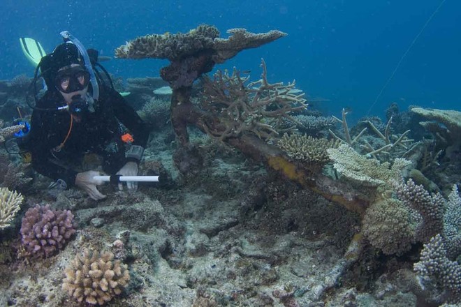
Xanthe Rivett/Australian National Maritime Museum
Scanning Flora Reef, 13 km east of the Frankland Islands off Cairns, they have found an anchor and other metal fittings which they consider probably mark the final resting place of HM Schooner Mermaid, a government vessel that ran aground and broke up on a voyage from Sydney to Port Raffles (in what is now the Northern Territory).
They hope to find further evidence in the next few days to confirm the vessel’s identity.
‘This is an historically significant shipwreck, and there have been several attempts to locate where it happened – all of them unsuccessful so far’, the leader of the museum team, maritime archaeologist and curator Kieran Hosty, said today.
‘There’s great excitement among the team at the strong prospect we’ve found it.’“
[Full Story]
|