|
the interview with Professor Masaaki Kimura continues
…
Morien Institute :
Before the series of abrupt glacier-meltings at the end of the last Ice Age, the whole area from what is now the Korean Peninsula, to Indo-China, was above sea level, with Okinawa being high mountains near the then coastline. Do you think that there might be many more underwater discoveries of monuments, and urban complexes, in the sea between modern mainland China and Okinawa?
Professor Masaaki Kimura :
“Yes. I think so. Not only the area you refer to but also around the world. There would be some difference as for urban or non-urban cultures due to the various places.”
The areas in ‘light grey’ represent the coastlines of south and east Asia as they are today, while the ‘green’ areas represent the coastlines as they were around 17,000 years ago – before the end of the last Ice Age. The ‘dark grey’ represents ‘tectonic sea-floor features’, and the map was produced for the Morien Institute by Dale R. Bennett who created an overlay of a 3 arc minute global projection of current coastlines over one of the same density projected for the period 15,000 to 10,000 BCE – the period when a series of glacial outpourings began, marking the end of the last Ice Age
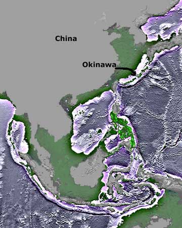
Dale R. Bennett
Morien Institute :
Do you think that Okinawa, and the Ryukyu Islands chain, could have been the major ports for maritime trade amongst the peoples of the last Ice Age for whom it was only possible to live in those southern latitudes?
Professor Masaaki Kimura :
“Okinawa could have been the major ports for maritime trade after the last Ice Age. Before it, the transportation had been along the land bridge from the Chinese mainland via Taiwan and Okinawa to the Japanese main Island during the last Ice Age.”
Morien Institute :
Could the Yonaguni No1 monument have been used as a jetty for ships to load and unload cargoes once the sea levels had begun to rise?
Professor Masaaki Kimura :
“Originally, the No.1 monument should have most been used as a jetty but also as a Gusuku mixed with Shrine and Castle. It would have been used only as a jetty when the sea level had begun to rise, because the place would then be too isolated in the ocean.”
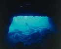
the ‘goddess rock’ discovered underwater at
‘San’ninu-dai’ on the east side of Yonaguni-jima
—
Okinawa, Japan
—
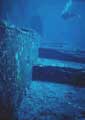
|
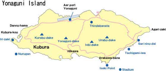
some steps on the ‘main terrace’ on
No.1 Monument at Iseki Point
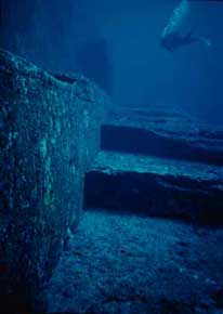
—
Okinawa, Japan
—
|
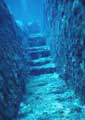
|
the ‘mizo stairs’ on the ‘upper terrace’ of No.1 Monument
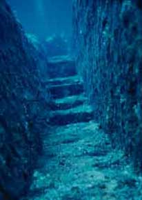
—
Okinawa, Japan
—
|
Morien Institute :
All measurements I have seen so far of the No. 1 monument tend to be approximations given in metric units, with the exception of some of the inscribed stones where they are precise, but still given in modern metric units. Has any study been undertaken using traditional Japanese or Okinawan units of measurement such as the ‘sun’, the ‘shaku’, the ‘ken’ or the ‘ri’?
Professor Masaaki Kimura :
“I do not research on metric units on the submarine monuments. Someone said Jomon units would have been used as a part of the monuments.”
Morien Institute :
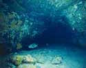
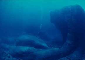
When it comes to evidence that Iseki Point was once well above sea-level, does the discovery of the Yonaguni ‘sea-floor stalactite cavern’ by Mr. Youhachirou Izumi, of the Yonaguni Diving Service, now put this fact beyond dispute?
Professor Masaaki Kimura :
“When it comes to evidence that Iseki Point was once well above sea-level, the Yonaguni ‘sea-floor stalactite cavern’ has been studied by me with scientific methods and now put this fact beyond dispute.”
The sea-floor ‘stalactite cavern’ was discovered by Mr. Youhachirou Izumi, of the Yonaguni Diving Service, and has been extensively studied by Prof. Masaaki Kimura and his students at the University of the Ruykyus, Okinawa. As can be seen from the image below showing a diver exploring inside the cavern, the ‘stalagmite’, which obviously formed on the ground over many centuries has joined with the ‘stalactite’, which formed over a similar period from the ceiling downwards. They are formed ‘only’ on dry land, when weakly acidic rainwater or river water seeps into a limestone plate, which then dissolves and eventually drips through into the cavern. This is the only way that this ‘stalactite cavern’ could have been formed – and it had to have formed when the cavern was last above sea-level 10,000 years ago.
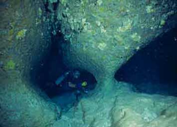
—
Okinawa, Japan
—
Morien Institute :
After studying the No 1 monuments at Yonaguni for more then 10 years, at what date would you now estimate it was last above sea level?
Professor Masaaki Kimura :
“After studying the No 1 monument at Yonaguni for more then 10 years, the structure may have been manufactured in the dry air about 10 thousand years ago based on such evidence as age determinations of the stalactite in the underwater caverns, and of the No.1 monument using 14C and 10Be methods.”
|
|
Books About
Prehistoric Japan
“Ancient Jomon of Japan”
by
Junko Habu

Get This Book From:
Amazon.com
Amazon.co.uk
“Prehistoric Japan:
New Perspectives on Insular East Asia”
by
Keiji Imamura
Get This Book From:
Amazon.com
Amazon.co.uk
“In the Wake of Jomon: Stone Age Mariners and a Voyage Across
the Pacific”
by
Jon Turk

Get This Book From:
Amazon.com
Amazon.co.uk
“An Archaeological History of Japan, 30,000 B.P. to A.D. 700”
by
Koji Mizoguchi
Get This Book From:
Amazon.com
Amazon.co.uk
“Sacred Texts and Buried Treasure:
Issues on the Historical Archaeology of Ancient Japan”
by
William Wayne Farris
Get This Book From:
Amazon.com
Amazon.co.uk
“Shinto:
The Sacred Art of Ancient Japan”
by
Victor Harris
(Editor)

Get This Book From:
Amazon.com
Amazon.co.uk
“Jomon of Japan:
The World’s Oldest Pottery”
by
Douglas Moore Kenrick
Get This Book From:
Amazon.com
Amazon.co.uk
“Underworld: Flooded
Kingdoms of the
Ice Age”
by
Graham Hancock

Get This Book From:
Amazon.com
Amazon.co.uk
if you would like to support
The Morien Institute
marine archaeology research
please send us a book

from our Wish List
|