“The founder and recognized leader of the Russian scientific school of tsunami researchers Sergey (1930-94) and his collaborators describe in detail the waves generated by earthquakes and accompanying phenomena in a region prone to earthquakes and where the written record allows a study of four millennia. Most of the material is quantitative information, including coordinates of the observation sites, dates, heights of tsunami run-ups, main parameters of the earthquakes, and tide gauge records. That is augmented by the electronic database created in the Tsumani Laboratory, Institute of Computational Mathematics and Mathematical Geophysics in Novosibirsk. Only geographical names are indexed.
“Tsunami: Monster Waves (American Disasters)”
Mary Dodson Wade
Janet Hamilton
EU English Edition
“Grade 4-7-Tsunamis, although not common, hold a fascination for both shore dwellers and inland inhabitants. The idea of a huge wave coming suddenly with little warning and capable of major devastation is both awesome and horrifying. This pedestrian book capitalizes on the destructive nature of these great waves.”
“Tidal Waves Wash Away Cities”
Kate Petty
EU English Edition
“Kids in grades 1-3 will enjoy this set of simple yet entertaining facts about tidal waves: from underwater volcanic action to tidal action and ocean problems, this packs in details about tidal waves and their effects on human habitation with over 30 pages including a glossary and bright photos set against black pages.”
“Landslides and Tsunamis”
Barbara Keating, Christopher Waythomas & Alastair Dawson
EU English Edition
“The study of tsunamis has been shifting away from theoretical modeling of tsunami source, wave propagation and runup toward multidisciplinary investigations, with an emphasis on field studies. This collection of papers highlights the many approaches being utilized to study landslides and tsunamis.”
“Caribbean Tsunamis: A 500-year History from 1498 – 1998″
Karen Fay O`Loughlin, James F. Lander (Editor)
EU English Edition
“In the past 500 years, the Caribbean region has had devastating tsunamis causing incalculable damage. It is an area of relatively high seismicity, and although tsunamis are not the chief natural hazard, they have the potential to produce catastrophic regional disasters.
“Today the necessity for awareness is of paramount importance. Tectonic forces continually build stress – until the inevitable release of strain that may trigger a tsunamigenic earthquake. The lack of a major tsunami in the past 57 years is due to a relative lack of relief of built-up energy, and the potential extent of the stress release grows as time elapses. The long period without relief of seismic stress buildup only increases the ominous threat of a devastating tsunami that could result from a sudden seafloor cataclysm.
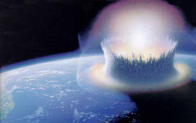
The links below are to pages that will give you more information on tsunami – the giant tidal waves that can be caused by undersea earthquakes, volcanoes, landslides, and, as it has recently been realised, by the impacts of asteroids, comets and meteorites in the oceans. Their incredible destructive power has been responsible for the sweeping away of many coastal towns, villages, and inundating huge landmasses throughout history and prehistory.
Following tsunami there is often very little evidence left for future archæologists to discover, and it is highly probable that much of the evidence of civilisation near coastal areas in prehistoric times has simply been wiped away by these incredible forces of nature.
One recent study has discovered that, according to radiocarbon dating of sediments from the area, a giant tsunami hit the eastern coast of Scotland in 5,800 BC. Stone tools found in the sand off Inverness showed that the waves hit the area without warning following a landslide off Storegga in north-west Norway.
Professor Smith, of the Department of Geography at Coventry University, told BBC News Online:
“It looks as if those people were happily sitting in their camp when this wave from the sea hit the camp. Professor Smith of the department of Geography at Coventry University told BBC News Online. We’re talking about two, three or four large waves followed by little ones, that would have been 5-10 metres high. These waves do strike with such force that they are very destructive. It’s like being hit by an express train’.”
A little further south, on Moel Tryfan in North Wales, the mashed and mangled remains of marine molluscs (sea-shells) have been found in so-called ‘Ice-Age drift deposits’ supposedly left there when the ice-sheets melted and retreated back towards the North Pole. But the composition of the supposed ice-sheet deposits told another story.
In their book “Cataclysm: Compelling Evidence of a Cosmic Catastrophe in 9,500 BB”, an academic study of the evidence suggesting that the flood myths of ancient times were based on archaic memories of a ‘real global tsunami’, or ‘deluge’, and which challenges the orthodox interpretation of geological history descending from the notions of a Pleistocene Ice Age theorised by Louis Agassiz in the 1820s, authors D. S. Allan and J. B. state:
“Eroded and fragmentary shells occur within the ‘drift’ deposits on Moel Tryfaen, a mountain in North Wales rising 1,300ft (400m) above sea level. Perplexingly the species represented include not only northern but also temperate and southern forms adapted to very varied habitats. Some required deep and others shallow water, some sandy and others muddy water, and some were peculiar to shingly and others to a bare rocky environment.
In stating that ice could never have brought together so varied a molluscan assemblage as this, it is hardly necessary to add that water could have – in which case the enveloping ‘drift’ deposits must have been similarly water-borne.”
In fact many of the ‘peculiarities’ conventionally attributed to an Ice Age simply could not have been created by the supposed advance and retreat of ice-sheets. Yet, if the many and various ‘flood-myths’ of antiquity, which have been passed down through millennia in the oral traditions of peoples worldwide, are based on true recollections of an ‘archaic deluge’, a catastrophic mega-tsunami could well have produced ALL of the phenomena now attributed to an Ice Age.
These would include:
the global distribution of ‘erratic boulders’ – especially in the latitudes which even the die-hard glaciologists admit were not covered with ice-sheets …
the multi-zone distribution of flora, fauna and marine life-forms in the composition of so-called ‘glacial drift’ in areas where no ice-sheets are even claimed to have existed …
and also in the pitiful conglomerations of broken and twisted remains of animals, birds, fish, trees and plants, pebbles, dirts and clays which can be found in caves and rock crevices in many areas around the world – not to mention the remains of whales and other sea creatures found on mountaintops – irrespective of theorised Pleistocene ice-sheet coverage …
NONE of these supposed ‘Ice Age Peculiarities’ could have been achieved solely by the action of Ice moving horizontally across hilly terrains. The nature of Ice is such that it cannot move uphill, and, as recent scientific surveys have concluded that there were never any huge mountains at the North Pole for ice-sheets to have slid down, ONLY the turbulent waters of mega-tsunami could have brought together such jumbles of life-forms, and forcibly jammed them into the small, tight places we find them today …
Was there really a Pleistocene Ice Age?
Or are the Deluge Traditions and Flood Myths of antiquity based on a sounder ancient understanding of:
Tsunami
Of course, it is always possible that an ocean-impact-related tsunami abruptly ended the Pleistocene Ice Age.
One of the best resources for understanding the
December 2004 Tsunami tragedy is the
January 30, 2007, BBC Bristol, England:
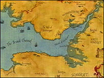
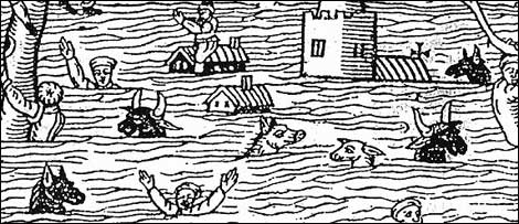
“Four hundred years ago, in the reign of James I of England, a disaster hit the south west of the country, as a huge surge of water coursed up the Bristol Channel – covering 200 square miles of land with water and killing 2,000 people.
BBC Bristol
Blue shading shows flooded areas
Eyewitness accounts of the great flood of 30 January 1607 tell of ‘huge and mighty hills of water’ advancing at a speed ‘faster than a greyhound can run’ and only receding 10 days later.
The flood reached a speed of 30mph and a height of 25ft.
It swept up to four miles inland in the Bristol area, north Devon, Pembrokeshire, Glamorgan, Monmouthshire and Cardiff – and up to 14 miles inland in low-lying parts of Somerset. But it is still not certain exactly what sparked the disaster which killed so many.
For centuries it was thought high tides and severe storms were to blame, a theory accepted by Dr Kevin Horsburgh from the Proudman Oceanographic Laboratory in Liverpool, who said a massive storm surge, formed by a combination of high tides and hurricane winds, may have been to blame.
BBC Bristol
But a tsunami theory was put forward by experts from Bath and Australia in 2004, supported by evidence of deposits of sand, pebbles and shell at various locations around the Severn Estuary where flood waters swept in, including Hill in South Gloucestershire.
It’s believed these deposits may have been brought in from the open ocean.” [Full Story]
January 30, 2007, BBC News Online, UK:
“A suspected tsunami in the Bristol Channel which killed 2,000 people happened 400 years ago on Tuesday.
Experts believe severe flooding on 30 January 1607 in south west England and south Wales was caused by a tsunami – and not a storm surge or high tides. It is estimated 200 square miles (520 sq km) of land were covered by water.
Simon Hasslett from Bath Spa University said there was currently no tsunami warning system in place. He said the research was important for informing coastal and risk management plans.
The flood of 1607 has been described by experts as the worst natural disaster to hit Britain. Eyewitness accounts of the disaster told of ‘huge and mighty hills of water’ advancing at a speed ‘faster than a greyhound can run’.” [Full Story]
Below are a selection of 2010-2019 stories from our
“The oral history wasn’t a myth. Tsunamis hit this tribal village five times, new study shows.
A legend about a great flood has been passed down through the centuries among the Klallam people on the north side of Washington’s Olympic Peninsula.
As re-told by Klallam elder Ed Sampson on a recording preserved by a University of North Texas linguist, the people noticed the fresh water turning salty — a detail from which we infer a tsunami.
In the story, a wise man warned the people to get ready. They scrambled into canoes provisioned with food and water.
The survivors rode out the flood by tying cedar ropes to the tops of the tallest mountains of the nearby Olympic Range.
Lower Elwha Klallam tribal chairwoman Frances Charles said now there’s proof this story ‘is not a myth’.
A team of researchers from Portland State University, Western Washington University and the University of Rhode Island found evidence that as many as five tsunamis hit an ancient Klallam village at present-day Port Angeles harbor.”
“The Italian island of Stromboli has long attracted residents and visitors thanks to its mild climate, fertile soils, and picturesque views.
But there’s a sinister side to Stromboli-the steep flanks of its active volcano periodically slough off, creating landslides that tumble into the sea and trigger tsunamis.
Now, geoscientists and archaeologists have shown that one of these events in the 14th century was likely responsible for the rapid abandonment of the island.
An enormous, deadly marine storm reported in Naples in 1343 was also probably due to the same tsunami waves, the researchers proposed.
These findings suggest that southern Italy is at a higher risk of tsunamis than previously known.”
“UNSW scientists have shown – for the first time – that a series of high-profile burial sites in the Pacific, Mediterranean and northern Scotland were likely related to catastrophic tsunamis.
The work was published in the Journal of Archaeological Method and Theory.
Honorary Professor James Goff from the PANGEA Research Centre at UNSW Sydney, who co-authored the paper, says the research provides new insights into past human-environment interactions and a new perspective on past catastrophic events.
‘Tsunamis have never been considered as explanations for burial sites before – which is why no prehistoric coastal mass graves have ever been identified in the archaeological record as tsunami-related.
‘Proving that a site is related to a past tsunami could lead to a fundamental rewrite of how we interpret coastal human settlement in prehistory, and change what we thought we knew about the culture and people living in the region at the time.
It could also have dramatic implications for how archaeologists analyse a site.’
The researchers looked at coastal mass burial sites in the Solomon Islands and Vanuatu as well as in Orkney and Shetland.
The mass graves cover a long timeframe of human history – they are from about 5000 years ago to as recent as about 500-600 years ago.”
“The devastating 2004 Indian Ocean tsunami caught millions of coastal residents and the scientific community off-guard.
Subsequent research in the Indian Ocean basin has identified prehistoric tsunamis, but the timing and recurrence intervals of such events are uncertain.
Here we present an extraordinary 7,400 year stratigraphic sequence of prehistoric tsunami deposits from a coastal cave in Aceh, Indonesia.
This record demonstrates that at least 11 prehistoric tsunamis struck the Aceh coast between 7,400 and 2,900 years ago.
The average time period between tsunamis is about 450 years with intervals ranging from a long, dormant period of over 2,000 years, to multiple tsunamis within the span of a century.”
“A dangerous tsunami is a series of waves that can be triggered by any event that disrupts the sea floor in some way.
They are usually caused by underwater earthquakes, but can also be caused by underwater landslides, nuclear weapons testing and even asteroids falling into the sea.
So why do tsunamis occur, and how does the monitoring system work?
Tsunamis can occur when there is a sudden movement or change within the ocean.
The majority are caused by underwater earthquakes, but there are a number of other events capable of triggering large waves, according to James Goff, Professor of Tsunami Science at the University of New South Wales.”
“When the eastern flank of a Cape Verde volcano splashed into the sea some 73,000 years ago, it generated an enormous wave that rose to 170 metres of height before it crashed into a nearby island, geophysicists have discovered.
The mega-tsunami, reported on 2 October in Science Advances1, is one of the largest in the geological record.
These kinds of apocalyptic events could happen again, although it is impossible to say when or where, says Ricardo Ramalho, a geophysicist at the University of Bristol, UK, and a co-author of the Cape Verde study.
‘Most of these fairly young oceanic volcanoes — such as in the Azores and the Canary Islands and Hawaii — are incredibly high and steep, so the potential energy for a collapse to happen again is there’, he says.
The flanks of some oceanic volcanoes periodically collapse. Huge amounts of rock slide down and displace the water below, triggering tsunamis.”
“The eastern coastline of Mexico’s Yucatan Peninsula, a mecca for tourists, may have been walloped by a tsunami between 1,500 and 900 years ago, says a new study involving Mexico’s Centro Ecological Akumal (CEA) and the University of Colorado Boulder.
There are several lines of evidence for an ancient tsunami, foremost a large, wedge-shaped berm about 15 feet above sea level paved with washing machine-sized stones, said the researchers.
Set back in places more than a quarter of a mile from shore, the berm stretches for at least 30 miles, alternating between rocky headlands and crescent beaches as it tracks the outline of the Caribbean coast near the plush resorts of Playa del Carmen and Cancun.
Radiocarbon dates of peat beneath the extensive berm indicate a tsunami, which may have consisted of two or even three giant waves, likely slammed the coastline sometime after A.D. 450.
In addition, ruins of Post-Classic Mayan structures built between A.D. 900 and 1200 were found atop parts of the berm, indicating the tsunami occurred prior to that time.”
“What causes a tsunami? Do all underwater earthquakes cause tsunamis? And what was the biggest tsunami ever?
Anything that disrupts the sea floor in some way has the potential to generate a tsunami, says James Goff, Professor of Tsunami Science at the University of New South Wales.
‘The main ones we hear about are the big ones caused by underwater earthquakes, but underwater landslides, nuclear weapons testing and even asteroids falling into the sea are all other possible causes’.
Underwater volcanoes are also capable of triggering large tsunamis, he says, with the 1883 Krakatau eruption generating a wave 30 metres high.
‘The largest historic tsunami happened in 1958 when a landslide fell into a fjord in Lituya Bay in Alaska’, he says.
“Geologists from GUtech, in cooperation with archeologists from the Ministry of Heritage and Culture, have dug up evidence of a tsunami or severe storm that hit Ras Al Hadd about 4,500 years ago.
Speaking to the Times of Oman about the new research, Dr Goesta Hoffman, Associate Professor from the Applied Geosciences Department at GUtech, said there is evidence of major flooding at an archeological site in Ras Al Hadd, a village on the coast of Oman about 240km southeast of Muscat.
Dr Hoffmann and other researchers from GUtech and its affiliated university in Germany have done extensive studies on the impact of tsunamis, storm and earthquakes on the coasts of Oman.
They focused on studying the rocks and soil, but they realised they could learn more by working with archeologists who are studying the remains of human settlements in Ras Al Hadd.
The archeologists had identified signs that a flood took place approximately 4,500 years ago.”
“By investigating the tell-tale signs of earthquakes and tsunamis written into the landscape over the last thousand years, Japanese scientists are rewriting the rule books for disaster prevention in the Pacific.
Scientific research teams drilling deep below the seabed where the 2011 Tohoku earthquake originated have also revealed what generated the gigantic tsunami – providing a new clue for identifying other areas in the Pacific that could trigger huge earthquakes and mega-tsunamis.” [Watch The Video and Read The Transcript]
“Archaeological work on the island of Gökçeada has revealed that an earthquake occurred in the region 4,700 years ago, followed by a tsunami.
Çanakkale Onsekiz Mart University Geology Department Professor Do?an Perinçek said they had found the traces of the earthquake and tsunami during works between 2006 and 2008.
Gökçek made a statement June 2 after an earthquake measuring 6.5 that occurred on May 24 in the region.
He said both he and Professor Halime Hürylmaz had found traces of an earthquake that occurred in 2680 B.C. following work in the area of Yenibademli.
‘The earthquake broke the walls of the settlements. There is also data that it created a tsunami. We have found the sediments of a tsunami in the region as well as a layer of earth of sand including fossils of sea creatures.
Ceramics that were found right below the tsunami sediments date back to 2680 B.C. This is why the earthquake and tsunami occurred before this date, which means it was 4,700 years ago’, he said. ”
“A prehistoric land mass once connecting Britain to mainland Europe may have been wiped out by a 5m-high tsunami, according to new research.
Some 8,000 years ago, a devastating subsea landslide off the coast of Norway generated a wave which overran the island of Doggerland, a low-lying Atlantis, which is now completely submerged.
‘It would have completely inundated the landmass’, says Dr Jon Hill, one of the team of researchers from Imperial College London, who have submitted their findings to the journal Ocean Modelling. ‘Any humans living there would have suffered a catastrophic event.’
There could have been inhabitants on the island at the time the waves struck, though this is still unclear from the evidence.
The Imperial team’s computer models suggest that Doggerland was mostly less than 5m above sea level at the time of the tsunami, suggesting flooding would have been extensive.
The trigger for the tsunami was a landslide named Storegga, where 3,000 cubic km of sediment collapsed in the North Sea.”
“A cave discovered near the source of Indonesia’s massive earthquake-spawned tsunami contains the footprints of past gigantic waves dating up to 7,500 years ago, a rare natural record that suggests the next disaster could be centuries away – or perhaps only decades.
The findings provide the longest and most detailed timeline for tsunamis that have occurred off the far western tip of Sumatra island in Aceh province.
Researchers in 2011 uncovered seabed sand deposits that were swept into the cave over thousands of years and neatly layered between bat droppings like a geological cake.
Radiocarbon analysis of materials, including clamshells and the remains of microscopic organisms, provided evidence of 11 tsunamis before 2004.
The disasters were by no means evenly spaced, said lead researcher Charles Rubin from the Earth Observatory of Singapore.
The last one occurred about 2,800 years ago, but there were four others in the preceding 500 years.”
“Scientists now understand why the 2011 Japanese tsunami was bigger than expected and say we need to prepare for larger tsunamis in the future.
The warning comes following an analysis of the quake which caused the tsunami, reported today in the journal Science.
‘Japan did not expect a tsunami that size. The country had a tsunami defence system in place but because it didn’t expect such large waves, the system was inadequate’, says Dr Virginia Toy, a geologist at the University of Otago in Dunedin, New Zealand, who was involved in the study.
‘We now realise we’ve got to build systems that have greater capacity.'”
“A detailed analysis of sediments from the island of Bonaire in the Caribbean presents convincing evidence for an extraordinary wave impact dating back some 3,300 years, even though no historical records of tsunamis exist for this island.
Of particular interest are the consequences this large wave impact had on the island’s ecosystem.
The sediments studied by the scientists suggested that this tsunami entirely changed the coastal ecosystem and sedimentation patterns in the area.
The work by Dr. Max Engel and colleagues, from the University of Köln in Germany, is published online in Springer’s journal, Naturwissenschaften — The Science of Nature.”
“A magnitude 7.7 earthquake struck the Canadian province of British Columbia late Saturday night, leading to short-lived tsunami warnings and mass evacuations as far away as Hawaii, according to various media reports.
The earthquake was centered in the Queen Charlotte Islands area (also known as Haida Gwaii) of British Columbia, US Geological Survey (USGS) officials told Mark Thiessen and Oskar Garcia of the Associated Press (AP), and was followed by a 5.8-magnitiude aftershock shortly thereafter.
The earthquake, which CBC News reported hit at approximately 8pm PT, caused at least three tsunami waves spotted off the coast of the province, and led to evacuations and tsunami warnings in Haida Gwaii and Port Edward, near Prince Rupert.
Additional tsunami waves were believed possible in Hawaii. However, in southern Alaska and British Columbia, the warning was downgraded to an advisory shortly after 5am ET Sunday morning.”
“This paper describes the topographic change and the recovery process, as well as the sediment sources, for tsunami deposits based on field surveys and analysis of digital elevation model data before and after the A.D. 2011 Tohoku-oki tsunami at the Sendai Plain, Japan.
We found that the amount of sediment deposited on land was approximately four times greater than the eroded volume of sediment at the beach.
Large amounts of the sediments deposited at the studied transect probably originated from liquefaction.
This result suggests that the vented sediments might have been an important source of the tsunami deposits if liquefaction is generated by the strong ground motion of a near-field earthquake.”
“Deepwater landslides are often underestimated as potential tsunami triggers.
The North Gorringe avalanche (NGA) is a large (?80 km3 and 35 km runout) newly discovered and deepwater (2900 m to 5100 m depth) mass failure located at the northern flank of Gorringe Bank on the southwest Iberian margin.
Steep slopes and pervasive fracturing are suggested as the main preconditioning factors for the NGA, while an earthquake is the most likely trigger mechanism.
Near-field tsunami simulations show that a mass failure similar to the NGA could generate a wave >15 m high that would hit the south Portuguese coasts in 30 min.”
“Professor James Goff digs up evidence of tsunamis from the past to find clues that could prepare us for future threats.
The Pacific Ocean is more vulnerable to natural events than any other place in the world — around 85 per cent of all tsunamis happen in this region.
In the past six years alone, major earthquake-triggered tsunamis have hit the Solomon Islands, Samoa, Chile, and Japan causing devastation.
What makes the region so vulnerable is the Pacific Ring of Fire that pretty much defines the boundary of the Pacific Ocean and is where more earthquakes and volcanic eruptions occur than anywhere else in the world, says Professor James Goff.”
“Archeologists have uncovered evidence of pre-farming people living in the Burren more than 6,000 years ago – one of the oldest habitations ever unearthed in Ireland.
Radiocarbon dating of a shellfish midden on Fanore Beach in north Clare have revealed it to be at least 6,000 years old – hundreds of years older than the nearby Poulnabrone dolmen.
The midden – a cooking area where nomad hunter-gatherers boiled or roasted shellfish – contained Stone Age implements, including two axes and a number of smaller stone tools.
Excavation of the site revealed a mysterious black layer of organic material, which archeologists believe may be the results of a Stone Age tsunami which hit the Clare coast, possibly wiping out the people who used the midden.
The archaeologists are also hoping to establish the make-up of a mysterious substance found during the excavation.
The substance, which is two or three inches deep, disintegrates when it comes in contact with air.
A large slab of the material has remained intact on an ancient settlement, indicating that a large amount of it was laid down at once, possibly as the result of a tsunami.”
February 2012 Edition, National Geographic, USA:
“Jin Sato is the mayor of a town that no longer exists.
Minamisanriku, a quiet fishing port north of Sendai in northeastern Japan, disappeared last March 11. Sato nearly did too.
Vött examined the site in the exploration of Paläotsunamis that have taken place over the last 11,000 years along the coasts of the eastern Mediterranean.
The disaster started at 2:46 p.m., about 80 miles east in the Pacific, along a fault buried deep under the seafloor. A 280-mile-long block of Earth’s crust suddenly lurched to the east, parts of it by nearly 80 feet.
Sato had just wrapped up a meeting at the town hall. ‘We were talking about the town’s tsunami defenses’, he says.
Another earthquake had jolted the region two days earlier—a precursor, scientists now realize, to the March 11 temblor, which has turned out to be the largest in Japan’s history.” [Read The Full Story]
[Browse more than 122 years of National Geographic magazine — all the articles, photographs, and maps published exactly as they appeared in print but now available on 6 DVD-ROMs.Find Out More A really good buy – Ed.]
July 07, 2011, Past Horizons, UK:
“Olympia, the Sanctuary of Zeus and venue of the Olympic Games in Ancient Greece, was probably destroyed by tsunamis that reached far inland, and not as previously believed, by earthquakes and river flooding.
This is the latest theory put forward by University Prof. Dr. Andreas Vött from the Geographical Institute of the Johannes Gutenberg University in Mainz (JGU).
Vött examined the site in the exploration of Paläotsunamis that have taken place over the last 11,000 years along the coasts of the eastern Mediterranean.
The Olympic-tsunami hypothesis has been put forward due to sediments found in the vicinity of Olympia, which were buried under an 8 metres thick layer of sand and other debris, and only rediscovered around 250 years ago.
‘The composition and thickness of the sediments we have found, do not fit with water flow of the river Kladeos and geomorphological events such as earthquakes”, said Vött. It was previously believed that an earthquake in 551 AD. destroyed the shrines and afterwards floods from the Kladeos filled the ancient buildings. [Full Story]
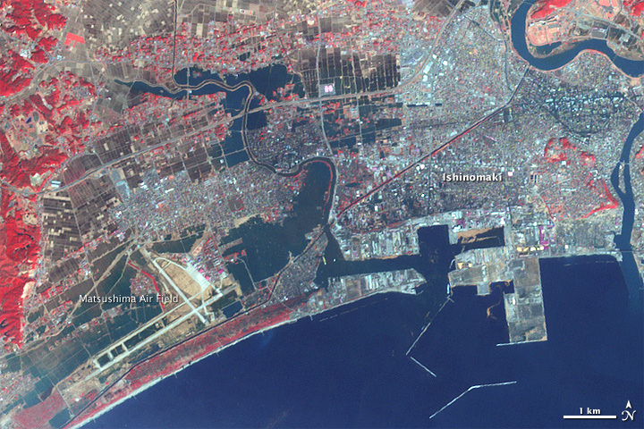
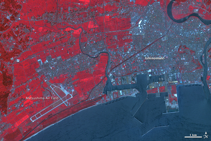
March 15, 2011, NASA Earth Observatory, Earth Orbit:
“The Japanese city of Ishinomaki was one of the hardest hit when a powerful tsunami swept ashore on March 11, 2011.
NASA Earth Observatory
When the Advanced Spaceborne Thermal Emission and Reflection Radiometer (ASTER) on NASA’s Terra satellite acquired the top image three days later, on March 14, water still inundated the city.
The lower image, from August 8, 2008, shows water levels under normal circumstances.
NASA Earth Observatory
Water is dark blue in this false-color image. Plant-covered land is red, exposed earth is tan, and the city is silver.
Standing water is most evident in the flat, open places that were once fields.
The most extensive flooding is around the Matsushima Air Base in the lower left corner of the image. According to news reports, several airplanes were damaged in the tsunami.
The neighborhoods immediately around the airstrip are also flooded.”
Below are some videos of the tsunami that hit Japan today.
Morien Institute News Editors Comments:
[It’s interesting to note that the Earth was hit just before midnight UT on March 9th 2011 by one of the largest Coronal Mass Ejections (CME) for a number of years. This massive solar flare measured as an X1.5-class CME, and reached the Earth’s magnetic field yesterday causing Northen Lights as far south as Wisconsin, Minnesota, and Michigan in the United States.
The NASA website, SpaceWeather.com, said that: “March 9th ended with a powerful solar flare. Earth-orbiting satellites detected an X1.5-class explosion from behemoth sunspot 1166 around 2323 UT.”. They have a regularly updated Northern Lights / Aurora Photo Gallery for each month going back a number of years, and the link above is for March 2011.
It is only in recent years that sophisticated spacecraft which can monitor the Sun and inner solar system for spaceweather that affects Earth have been able to accurately measure and classify the activities of our star, and interpretation of events such as CMEs is still in its infancy regarding the full spectrum of their affects on the inner planets, including our own.
Today, March 11th 2011, the SpaceWeather.com, site says that: “After four years without any X-flares, the sun has produced two of the powerful blasts in less than one month: Feb. 15th and March 9th. This continues the recent trend of increasing solar activity, and shows that Solar Cycle 24 is heating up. NOAA forecasters estimate a 5% chance of more X-flares during the next 24 hours.”.
This dearth of X-class flares happened because of the recent 2008/2009 Solar Minimum, which was the the longest for over 100 years, and saw the longest number of days without sunspots since the Maunder Minimum that lasted from approximately 1645 to around 1715.
The Maunder Minimum coincided with the Little Ice Age, a period of intense cold that Al Gore and other ‘global warming scaremongers’ tried to hide when they flattened-out the data to produce their now infamous “hocky-stick graph” as part of a scam to raise continuing research funds for compliant scientists, and fleece us with green taxes.
It’s interesting to note that the major 6.3 earthquake that hit Christchurch, New Zealand, on February 22nd 2011 was just around a week after the February 15th 2011 X-class solar flare, though any connection between these events on the Sun that can produce major radiation storms and tectonic activity here on Earth is purely speculative at present.
August 09, 2011, ESA News, France:
“The effects of the March 2011 earthquake and subsequent tsunami that devastated areas of Japan can be seen as far away as Antarctica.
Satellite images show new icebergs were created after the tsunami hit the Sulzberger Ice Shelf.
Using radar images acquired by ESA’s Envisat satellite, a NASA team was able to spot the icebergs – the largest measuring about 6.5 by 9.5 km in surface area and about 80 m in thickness.
The findings linking the tsunami to the calving event by NASA’s Kelly Brunt, a cryosphere specialist at Goddard Space Flight Center in Maryland, and her colleagues were published in the online Journal of Glaciology on Monday.
The Tohoku 9.0 magnitude earthquake that stuck off the coast of Japan triggered a tsunami with giant waves.
The waves then propagated through the Pacific Ocean over 13 000 km south to the Sulzberger Ice Shelf in Antarctica, causing large chunks of ice to break off and float into the Ross Sea.” [Full Story]
August 09, 2011, NASA Earth Observatory, Earth Orbit:
“Using satellite radar data, scientists recently observed the calving of several large icebergs from the Sulzberger Ice Shelf along the Antarctic coast as a result of the March 2011 tsunami half a world away in Japan.
Scientists have long speculated that ocean waves could cause an ice shelf to flex and break, but this is the first time researchers have observed a tsunami having this effect.
Icebergs can form in any number of ways, but much of the time, the process is out of sight. Often, scientists see large chunks drifting in polar seas, and then have to work backwards to figure out the point of origin.
In this case, a research team led by Kelly Brunt of NASA’s Goddard Space Flight Center looked ahead, not back.
When the Tohoku earthquake and tsunami occurred off Japan on March 11, 2011, the ice researchers immediately looked south as the massive waves exploded out from the epicenter in the northwest Pacific Ocean.
The scientists checked records for vulnerable faces of the Antarctic coast and studied models of the likely wave propagation. Within 18 hours of the earthquake, the tsunami waves had traveled 8,000 miles (13,600 kilometers) and reached the shores of Antarctica. “ [Full Story]
March 13, 2011, The Epoch Times, USA:
“Atlantis, the fabled lost city mentioned since antiquity, may have been found recently by researchers, according to research by Spanish, American, and Canadian scientists.
The legendary lost city may be located in mud flats in southern Spain, said a team of scientists from the University of Hartford in Connecticut.
Researchers led by Hartford professor and archaeologist Richard Freund used satellite imagery, electrical resistivity tomography, digital mapping, ground penetrating radar, and underwater technology to locate the city, believed to have been submerged after a tsunami.
They matched geological formations from Plato’s descriptions of Atlantis and date artifacts to the time of the lost city to see if they can confirm the existence of the city.
About 2,600 years ago, Plato said that the lost city was ‘an island situated in front of the straits which are by you called the Pillars of Hercules’, according to a press release.” [Full Story]
March 11, 2011, The Japan Times, Japan:
“A powerful earthquake with a magnitude of 8.8 struck a wide area of northeastern and eastern Japan including Tokyo on Friday, triggering a massive tsunami that swept away houses and cars in Miyagi Prefecture and killing at least 32 people.
The 2:46 p.m. earthquake is the strongest ever to have been observed in the quake-prone archipelago by the Japan Meteorological Agency, the governmental agency said, with its magnitude surpassing the 7.9 registered in the 1923 Great Kanto Earthquake in Tokyo and its vicinity, which killed more than 100,000 people.
A wide, muddy stream was seen moving rapidly across a residential area near Natori River in Miyagi on live TV coverage by public broadcaster NHK, leveling everything in its path. The tsunami also reached Sendai airport, submerging the runway.
The biggest of tsunamis that followed the quake was a 10-meter one observed at Sendai port in Sendai, Miyagi Prefecture, in northeastern Japan, at around 3:55 p.m.” [Full Story]
February 15, 2011, BBC News Magazine, UK:
“The coastline and landscape of what would become modern Britain began to emerge at the end of the last Ice Age around 10,000 years ago.
What had been a cold, dry tundra on the north-western edge of Europe grew warmer and wetter as the ice caps melted.
The Irish Sea, North Sea and the Channel were all dry land, albeit land slowly being submerged as sea levels rose.
Ancient Britain was a peninsula until a tsunami flooded its land-links to Europe some 8,000 years ago. Did that wave help shape the national character?
Thinkstock / BBC News Magazine, UK
But it wasn’t until 6,100BC that Britain broke free of mainland Europe for good, during the Mesolithic period – the Middle Stone Age.
It is thought that landslides in Norway – the Storegga Slides – triggered one of the biggest tsunamis ever recorded on Earth when a landlocked sea in the Norwegian trench burst its banks.
The water struck the north-east of Britain with such force it travelled 40km inland, turning low-lying plains into what is now the North Sea, and marshlands to the south into the Channel. Britain became an island nation.” [Full Story]
if you would like to support our marine archaeology research please send us a book
from our Wish List
Ancient Mysteries
Bookshoppe
for a wide selection of
books that challenge
orthodox views of
prehistory on
our planet :
“Eden in the East: The Drowned Continent of Southeast Asia”
Stephen Oppenheimer
EU English Edition
“A book that completetly changes the established and conventional view of prehistory by relocating the Lost Eden – the world’s 1st civilization – to SouthEast Asia. At the end of the Ice Age, SouthEast Asia formed a continent twice the size of India, which included Indochina, Malaysia, Indonesia and Borneo.
The South China Sea, the Gulf of Thailand and the Java sea, which were all dry, formed the connecting parts of the continent. Geologically, this half sunken continent is the Shunda shelf or Sundaland.
He produces evidence from ethnography, archaeology, oceanography, from creation stories, myths and sagas and from linguistics and DNA analysis, to argue that this founder civilization was destroyed by a catastrophic flood, caused by a rapid rise in the sea level at the end of the last ice age.”
“Red, Earth, White Lies: Native Americans & the Myth of Scientific Fact”
Vine Deloria
EU English Edition
“Leading Native American scholar and author of the best-selling books God Is Red and Custer Died for Your Sins, Vine Deloria, Jr., addresses the conflict between mainstream scientific theory about the world and the ancestral worldview of Native Americans. Claiming that science has created a largely fictional scenario for American Indians in prehistoric North America, Deloria offers an alternative view of the continent’s history as seen through the eyes and memories of Native Americans.
“Furious Earth: The Science and Nature of Earthquakes, Volcanoes, and Tsunamis”
Ellen J. Prager
EU English Edition
from the back cover:
“The Science Behind the Earth’s Most Catastrophic Phenomena. If our planet is a sleeping giant, it slumbers fitfully and awakens in powerful starts. Our familiar landscape bears the scars f hidden forces at work deep beneath it. Furious Earth contains the latest science on these forces and the cataclysmic phenomena they produce – earthquakes, volcanoes, and tsunamis.
Now, hard-won knowledge of these phenomena, gained often in the aftermath of disaster or through dangerous research efforts, is presented here by scientist Ellen Prager with the following experts: Stanley Willaims, Ph.D. Professor of Volcanology, Arizona State University, on volcanoes; Kate Hutton, Ph.D., Seismologist, California State Institute of Technology, on earthquakes; Costas Synolakis, Ph.D., Professor of Civil Engineering, University of Southern California, on tsunamis.”
Japan’s Mysterious Pyramids: YONAGUNI
Do undersea relics near Okinawa offer proof of a sophisticated civilization during the last ice age?
There are so many ‘flood myths’, ‘deluge traditions’, and stories of ‘sunken lands’ from almost every corner of the world which have been passed down through millennia via the oral traditions of so many cultures that it is no longer ‘scientific’ to dismiss them as ‘unscientific’.
To place no scientific value on the ‘oral traditions’ of the many different cultures whose ancient indigenous knowledge can be traced back many millennia is sheer folly, and such contempt for the natural science’ and philosophies of peoples who still live close to nature demonstrates just how far modern science has strayed from the very nature that science is supposed to be studying.
The Morien Institute ‘Marine Archaeology News Archive’ offers just a small selection of stories about recent underwater discoveries which date from 1997 to 2016, and concern the mounting evidence of urban remains that suggest a global history of ‘catastrophic inundations’ and ‘tsunami events’ far greater than previously believed by mainstream academics …
Share This Page
With Your Favourite Social Networks
|
|
|
|
|
|
|
|
|
|
|
|
|
Tweet This Page
please take a look at ourAncient Mysteries Bookshoppefor a wide selection of books
that challenge orthodox views of prehistory on every continent