|
The links below are to pages that will give you more information on tsunami – the giant tidal waves that can be caused by undersea earthquakes, volcanoes, landslides, and, as it has recently been realised, by the impacts of asteroids, comets and meteorites in the oceans. Their incredible destructive power has been responsible for the sweeping away of many coastal towns, villages, and inundating huge landmasses throughout history and prehistory.
Following tsunami there is often very little evidence left for future archæologists to discover, and it is highly probable that much of the evidence of civilisation near coastal areas in prehistoric times has simply been wiped away by these incredible forces of nature.
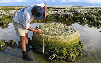
One recent study has discovered that, according to radiocarbon dating of sediments from the area, a ‘giant tsunami’ hit the eastern coast of Scotland in 5,800 BC. Stone tools found in the sand off Inverness showed that the waves hit the area without warning following a landslide off Storegga in north-west Norway.
Professor Smith, of the Department of Geography at Coventry University, told
BBC News Online:
“It looks as if those people were happily sitting in their camp when this wave from the sea hit the camp. Professor Smith of the department of Geography at Coventry University told BBC News Online. We’re talking about two, three or four large waves followed by little ones, that would have been 5-10 metres high. These waves do strike with such force that they are very destructive. It’s like being hit by an express train’.”
A little further south, on Moel Tryfan in North Wales, the mashed and mangled remains of marine molluscs (sea-shells) have been found in so-called ‘Ice-Age drift deposits’ supposedly left there when the ice-sheets melted and retreated back towards the North Pole. But the composition of the supposed ice-sheet deposits told another story.
In their book “Cataclysm: Compelling Evidence of a Cosmic Catastrophe in 9,500 BB”, an academic study of the evidence suggesting that the flood myths of ancient times were based on archaic memories of a ‘real global tsunami’, or ‘deluge’, and which challenges the orthodox interpretation of geological history descending from the notions of a Pleistocene Ice Age theorised by Louis Agassiz in the 1820s, authors D. S. Allan and J. B. state:
“Eroded and fragmentary shells occur within the ‘drift’ deposits on Moel Tryfaen, a mountain in North Wales rising 1,300ft (400m) above sea level. Perplexingly the species represented include not only northern but also temperate and southern forms adapted to very varied habitats. Some required deep and others shallow water, some sandy and others muddy water, and some were peculiar to shingly and others to a bare rocky environment.
In stating that ice could never have brought together so varied a molluscan assemblage as this, it is hardly necessary to add that water could have – in which case the enveloping drift’ deposits must have been similarly water-borne.”
In fact many of the ‘peculiarities’ conventionally attributed to an Ice Age simply could not have been created by the supposed advance and retreat of ice-sheets. Yet, if the many and various ‘flood-myths’ of antiquity, which have been passed down through millennia in the oral traditions of peoples worldwide, are based on true recollections of an ‘archaic deluge’, a catastrophic mega-tsunami could well have produced ALL of the phenomena now attributed to an Ice Age.
These would include:
-
the global distribution of ‘erratic boulders’ – especially in the latitudes which even the die-hard glaciologists admit were not covered with ice-sheets …
-
the multi-zone distribution of flora, fauna and marine life-forms in the composition of so-called ‘glacial drift’ in areas where no ice-sheets are even claimed to have existed …
-
and also in the pitiful conglomerations of broken and twisted remains of animals, birds, fish, trees and plants, pebbles, dirts and clays which can be found in caves and rock crevices in many areas around the world – not to mention the remains of whales and other sea creatures found on mountaintops – irrespective of theorised Pleistocene ice-sheet coverage …
NONE of these supposed ‘Ice Age Peculiarities’ could have been achieved solely by the action of Ice moving horizontally across hilly terrains. The nature of Ice is such that it cannot move uphill, and, as recent scientific surveys have concluded that there were never any huge mountains at the North Pole for ice-sheets to have slid down, ONLY the turbulent waters of mega-tsunami could have brought together such jumbles of life-forms, and forcibly jammed them into the small, tight places we find them today …
Was there really an Ice Age?
Or are the Deluge Traditions and Flood Myths of antiquity based on a sounder ancient science:
Tsunami
One of the best resources for understanding the
December 2004 Tsunami tragedy is the
Sydney Morning Herald’s
Interactive Tsunami Map
Official Tsunami Monitoring Centres :
International Tsunami Information Centre
Yuzhno-Sakhalinsk Tsunami Warning Center
National Geophysical Data Center – Tsunami Database
NOAA Tsunami Research Center
FEMA Fact Sheet: Tsunami
West Coast & Alaska Tsunami Warning Center
–
Latest Tsunami Bulletin
–
Pacific Tsunami Warning Center
–
Latest Tsunami Bulletin
–
Recorded Recent Tsunami
below are some details from a selection of recent stories in
our news headlines archive in latest date order
…
“Tsunami anniversary evokes guilt complex in scientists”
December 24, 2006, Telugu Portal, India:
“While prayers and ceremonies worldwide will mark the second anniversary of the Asian tsunami on Tuesday, it has stirred up a feeling of remorse among Indian geologists.
Would the loss of lives – 12,405 Indians confirmed dead – have been much less had they conducted any detailed geological investigations of the Indian coast prior to the Boxing Day disaster?
Tsunami geologist Chittenipattu Rajendran of the government-run Centre for Earth Science Studies at Akkulam in Kerala firmly believes so.
He has reasons to. Rajendran and co-workers have just discovered that the east coast of India had been devastated twice by powerful tsunamis around 1,500 and 1,000 years ago. The ancient tsunamis churned waters at depths of 50 metres causing floods that swept through 800 metres of coast, burying the famed temples built by Pallava kings at Mamallapuram, 55 km south of Chennai.
We reported on the discovery of the remains of the temples at Mamallapuram (Mahabalipuram) in June 2002. They were found underwater at the point where the ancient tsunami struck. [Ed.]
Evidence of all this has come from sediments preserved within two deep trenches at the Mamallapuram beach site excavated by the Archaeological Survey of India after the December 2004 tsunami.
Rajendran, whose group announced this discovery last month in the journal Current Science, feels bad that such investigations were not carried out prior to the tragedy.
‘We should have stuck our neck out much before the 2004 tsunami to look at the geological archives preserved in our coasts to understand their recurrence pattern’, Rajendran told IANS in an email interview.
Rajendran’s team with funding from the science ministry is looking at Kaveripatnam, another historical site on the east coast of India, for more evidence of ancient tsunamis.
‘Large historical tsunami events that affected these areas are referred to in the ancient Tamil epics like ‘Manimekahlai’, he said. ‘It has been a bit of a detective work, but we are hopeful of more clinching geological evidence for these historical references.”
[Full Story]
“How Etna’s Neolithic hiccup set off a tsunami”
December 13, 2006, New Scientist, UK:
“When the east flank of Mount Etna collapsed into the sea around 8500 years ago, it triggered a tsunami that devastated the Neolithic villages of the eastern Mediterranean.
If it were to happen today the wall of water would clobber coastal cities from southern Italy to parts of Israel.
Watch a sumulation here
The largest active volcano in Europe, Etna towers 3.3 kilometres above eastern Sicily. When the east flank collapsed in the eruption all those years ago the resulting landslide left a depression now called Valle del Bove.
Earlier this year, Maria Pareschi of the Italian National Institute of Geophysics and Volcanology in Pisa discovered that sediment from Etna’s ancient landslide stretched offshore for 250 square kilometres.”
[Full Story]
“Ancient tsunami engulfed Mediterranean coastline”
December 01, 2006, XinhuaNet, China:
“Imagine a volcano avalanche generated tsunami 10 stories high containing enough sediment and rock to cover the entire island of Manhattan with a layer of debris thicker than the height of Empire State Building.
According to a computer simulation, that’s what happened 8,000 years ago in Sicily when Mt. Etna erupted and produced an avalanche that hurled six cubic miles of dirt and rock into the water, creating a tsunami that spread across the entire Mediterranean Sea and onto the shore of three continents in only a few hours.
|
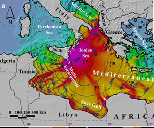
International Herald Tribune
Maximum wave crests heights predicted by a computer
simulation of the ancient event. Blue lines are
arrival times of the first tsunami waves.
|
The mountain of rubble swept into the sea at more than 200 mph, pulverized the sea bed and changed thick layers of soft marine sediment into jelly. It also started an underwater mudslide that flowed for hundreds of miles.
Researchers at the National Institute of Geology and Volcanolgy in Italy have also linked the tsunami with the mysterious abandonment of Atlit-Yam, a Neolithic village located along the coast of present-day Israel.”
[Full Story]
“The tsunami of 13 December A.D. 115 and the
destruction of Herod the Great’s harbor
at Caesarea Maritima, Israel”
December 2006 Edition, Geology, USA:
Underwater geoarchaeological excavations on the shallow shelf
(10 m depth) at Caesarea, Israel, have documented a tsunami that struck and damaged the ancient harbor at Caesarea. Talmudic sources record a tsunami that struck on 13 December A.D. 115, impacting Caesarea and Yavne.
The tsunami was probably triggered by an earthquake that destroyed Antioch, and was generated somewhere on the Cyprian Arc fault system. The tsunami deposit consisted of an 0.5-m-thick bed of reverse-graded shells, coarse sand, pebbles, and pottery deposited over a large area outside of the harbor.
Radiocarbon dating of articulated Glycymeris shells, and optically stimulated luminescence (OSL) dates, constrain the age of the deposit to between the first century B.C. and the second century A.D., and point to the tsunami of A.D. 115 as the most likely candidate for the event, and the probable cause of the harbor destruction.”
[Full Story requires registration]
“Giant 8,000-year-old tsunami is studied”
November 28, 2006, UPI, USA:
Italian scientists say geological evidence suggests a giant tsunami resulted from the collapse of the eastern flanks of Mount Etna nearly 8,000 years ago.
The collapse of the volcano, located on Italy’s island of Sicily, was studied by Maria Teresa Pareschi and colleagues at Italy’s National Institute of Geophysics and Volcanology.
They modeled the collapse and discovered the volume of landslide material, combined with the force of the debris avalanche, would have generated a catastrophic tsunami, impacting the entire Eastern Mediterranean.
Simulations show the resulting tsunami waves would have destabilized soft marine sediments across the floor of the Ionian Sea.”
[Full Story]
“Origin of earthquake, tsunami hoax probed”
November 28, 2006, Honolulu Advertiser, Hawai’i:
State and city officials are trying to determine the source of an earthquake and tsunami hoax on Sunday that sent hundreds of people to higher ground and tied up emergency communication lines for hours.
Civil defense, police, Pacific Tsunami Warning Center and media were inundated Sunday with more than 800 calls from people trying to verify rumors that predicted a Big Island earthquake that would cause a major tsunami, supposedly due to hit the Islands Sunday night.
Officials scrambled to squelch the rumor, but it persisted for hours as people rushed to fill gasoline tanks, purchased emergency supplies and sought refuge. At this point, the best evidence points to an e-mail that may have originated in Australia.”
[Full Story]
“Ancient crash, epic wave”
November 14, 2006, IHT, France:
“At the southern end of Madagascar lie four enormous wedge-shaped sediment deposits, called chevrons, that are composed of material from the ocean floor. Each covers twice the area of Manhattan with sediment as deep as the Chrysler Building is high.
On close inspection, the chevron deposits contain deep ocean microfossils that are fused with a medley of metals typically formed by cosmic impacts. And all of them point in the same direction – toward the middle of the Indian Ocean where a newly discovered crater, 18 miles in diameter, lies 12,500 feet below the surface..
|
International Herald Tribune
|
The explanation is obvious to some scientists. A large asteroid or comet, the kind that could kill a quarter of the world’s population, smashed into the Indian Ocean 4,800 years ago, producing a tsunami at least 600 feet high, about 13 times as big as the one that inundated Indonesia nearly two years ago. The wave carried the huge deposits of sediment to land.
Most astronomers doubt that any large comets or asteroids have crashed into the Earth in the last 10,000 years. But the self-described ‘band of misfits’ that make up the two-year-old Holocene Impact Working Group say that astronomers simply have not known how or where to look for evidence of such impacts along the world’s shorelines and in the deep ocean.
Scientists in the working group say the evidence for such impacts during the last 10,000 years, known as the Holocene epoch, is strong enough to overturn current estimates of how often the Earth suffers a violent impact on the order of a 10-megaton explosion.
Instead of once in 500,000 to one million years, as astronomers now calculate, catastrophic impacts could happen every few thousand years.”
[Full Story]
“Underwater slide kicked up tsunami, geology shows”
October 26, 2006, San Francisco Chronicle, USA:
“A giant underwater landslide that gouged the bottom of Lake Tahoe thousands of years ago sent a tsunami coursing across the lake and left huge ripples of rock that remain today, geologists have discovered.
Three scuba divers, a robot submarine from Santa Clara University and teams from the U.S. Geological Survey and the University of Nevada in Reno combined forces to piece the story together from evidence they gathered during two years spent surveying what lies beneath the lake’s storied blue waters just offshore from Tahoe City (Placer County).
The scientists say damaging waves from future landslides along the lake’s steep underwater cliffs are clearly possible – but just when, they cannot say.”
[Full Story]
“Culture clash stalls tsunami recovery”
October 08, 2006, IHT, France:
“A $245 million stretch of blacktop intended to be the signature goodwill gesture from the American people to survivors of the 2004 tsunami has instead become a parable of the problems of Aceh’s recovery effort.
Construction of the 240 kilometer, or 150-mile, road along the devastated coast has yet to start, stalled by a host of obstacles like acquiring right of way through residential and farmland. Though villagers welcome the idea, some have reservations about an American-style thoroughfare with a wide shoulder on either side.
Villagers say they fear speeding traffic and want to be able to sell snacks and tea from stalls snug by the roadside, as they have always done. And they resist disturbing numerous graves along the route, some of which are revered for their traditional mysticism, and others for their Islamic significance.”
[Full Story]
“Killer waves: not just tales from the deep”
July 29, 2006, IOL/The Independent, South Africa:
“Once, they were regarded as maritime myth and legend. Freak waves that rose 30m from the ocean and snapped ships in half were given as much credence by scientists as the existence of mermaids.
Now it seems the fantastic accounts by sailors through the ages might have been more than just tales of the deep. Research suggests up to 10 gigantic ‘rogue waves’ – some as tall as a 10-storey building – are likely to be crashing through the world’s oceans at any given moment.
Dr Wolfgang Rosenthal, who helped the European Space Agency pioneer a study using satellite surveillance, said: ‘Two large ships sink every week on average. But the cause is never studied to the same detail as an air crash. It simply gets put down to ‘bad weather’.’“
[Full Story]
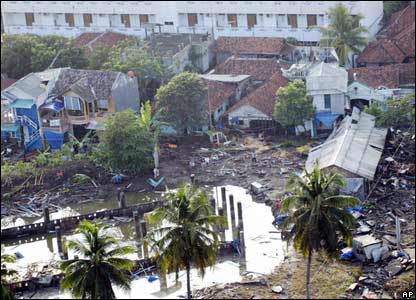
“In pictures: Indonesian tsunami”
July 18, 2006, BBC News Online, UK: “Hundreds of people are now known to have been killed in a tsunami which struck the town of Pangandaran on the Indonesian island of Java.
|
BBC News Online
|
The tsunami was triggered by a magnitude 7.7 undersea earthquake which shook buildings in the capital, Jakarta, some 270km (170 miles) away.
Hotels, businesses and houses were devastated by the two-metre-high wave which hit the resort town on Monday afternoon.”
[Full Story]
“Java earthquake sets off 6m tsunami, kills five”
July 18, 2006, BusinessDay, South Africa:
“An earthquake struck south of Indonesia’s Java island, triggering a tsunami and killing at least five people, said Indonesian President Susilo Bam-bang Yudhoyono in Jakarta yesterday.
The 7.2 magnitude quake occurred beneath the sea about 260km south of Bandung, Java, at 3.19pm local time, says a preliminary report on the US Geological Survey website. There was a 6.1 magnitude aftershock.
The site is located at Eriksdal, in the southernmost province of Sweden, Skåne. Scandinavia and the Baltic formed a continent 145 million years ago, around the Jurassic-Cretaceous transition.
‘Search teams are still working as we speak’‘ Yudhoyono said. ‘The local government has started to evacuate people.’
Indonesia was the country worst hit by the December 26 2004 tsunami that devastated coastal communities around the Indian Ocean, killing more than 200000 people from Indonesia and Thailand to the Maldives, Sri Lanka and Somalia and leaving hundreds of thousands homeless.
Yesterday’s quake ‘generated cascading tsunami waves of 3m-6m; the largest wave by far was 6m’, said Puji Pujiono, regional disaster response adviser for the United Nations Office for the Co-ordination of Humanitarian Affairs, from Yogyakarta.”
[Full Story]
“Traces of a tsunami in Sweden”
May 23, 2006, Innovations-Report, Germany: “145 million years ago Scandinavia was hit by a tsunami, probably more intense than the one that hit Southeastern Asia in December 2004.
Traces of this ancient tsunami are still left and these have been discovered by the geologists Vivi Vajda and Jane Wigforss-Lange at Lund University. The scientific results will soon be published in the journal Progress in Natural Science.
The site is located at Eriksdal, in the southernmost province of Sweden, Skåne. Scandinavia and the Baltic formed a continent 145 million years ago, around the Jurassic-Cretaceous transition.
The coast line cut through Skåne and the area around Eriksdal was a delta environment. At this time Sweden was situated at the same latitude as the Mediterranean of today and the climate was globally warm, not even the poles were ice capped.
In Scandinavia tree ferns, gingkoes and cycads were thriving and the fauna was dominated by dinosaurs. The coast was inhabited by sharks, crocodiles and tetrapods (now extinct giant amphibians).
The 30 metre thick section in Eriksdal is hid in a farmland and can only be accessed by extensive digging and the sediments are tilted so the layers are vertical. In the sediments we found fossils of fish, mussels, snails mixed with landplants, says Vivi Vajda.”
[Full Story]
“Montserrat’s volcano threatens the region
with tsunamis”
May 22, 2006, Caribbean Net News, Cayman Islands: “Around 7:20am, Saturday, 20 May 2006, residents of Montserrat witnessed the first dome collapse pyroclastic flow as it reached the sea. All eyes turned to the sky.
Scientists at the Montserrat Volcano Observatory (MVO) say they recorded signals of increased activity around 6am, Saturday morning.
Expecting that this dome collapse episode could go on for hours, the biggest concern was the possibility of explosive periods triggering pyroclastic flows into Tyres Ghaut, which is the upper reaches leading into the Belham River Valley.
The MVO’s scientist also said that another concern was the threat of tsunamis from the continuing pyroclastic flows of this eruptive event entering the sea.
The official coastal warning states, ‘Following a collapse of the dome at the Soufriére Hills Volcano in Montserrat in the early hours of Saturday, 20 May 2006, it has been reported that a tsunami has affected some coastal areas of Guadeloupe. There are unconfirmed reports that English Harbour and Jolly Harbour in Antigua have been affected.’
The MVO’s Director reported that Guadeloupe had a tsunami 3 feet high and an unconfirmed report that Antigua also experienced a possible tsunami ranging between 8 to 12 inches.”
[Full Story]
“Scientist backs Pacific tsunami warning”
May 04, 2006, Sydney Morning Herald, Australia: “A Pacific tsunami warning, which later proved unnecessary after an earthquake off Tonga, was a prudent move, an Australia scientist says.
Geoscience Australia seismologist David Jepson said the earthquake measured 8.0 on the Richter scale, and was regarded as a very significant event.
But is was 100 times smaller than the December 2004 magnitude 9.3 earthquake in the Indian Ocean off Sumatra which produced the devastating Boxing Day Tsunami.
Dr Jepson said initiating a tsunami alert through the Pacific Tsunami Warning Centre was a prudent precaution.
‘It is easier to cancel a warning than for people to be drowned’, Dr Jepson said. ‘Shallow earthquakes of this size can be very destructive and can cause serious damage up to 500 kilometres from the epicentre.’
‘There are different trigger points for saying whether it could be a Pacific wide tsunami or just a local tsunami and this fitted in with the size of a Pacific wide tsunami’
Following the earthquake, a tsunami warning was issued for Tonga and surrounding areas including American Samoa, Samoa, Fiji, and the east coast of New Zealand.”
[Full Story]
“Hurricanes can also trigger tsunamis”
April 21, 2006, New Kerala, India: “Ever thought hurricanes could stir up a tsunami? Well according to US Naval researchers at Stennis Space Center in Mississippi hurricanes can pile up sediments beneath the water surface that could break formation, and create a tsunami.
They said that studies have shown that unexplained landslides in the Gulf of Mexico between 5000 and 10000 years ago created waves more than 15 metres high that smashed into the coast of Texas. And before that, a slump near the Mississippi Delta caused a wave probably at least twice as big to hit shore.
They said that the usual suspect might be earthquakes, but the Gulf of Mexico was not seismically active, so the most probable reason for the tsunamis was ancient hurricanes.
Researchers William Teague and his colleagues who have studied hurricanes for quite long said that Hurricane Ivan, which caused massive damage in Grenada, Jamaica, Florida and Alabama in 2004, created waves as high as 40 metres.”
[Full Story]
“Geologists: Ancient tsunami probably struck Saipan”
April 17, 2006, Saipan Tribune, Micronesia: “Two visiting geologists from the U.S. Geological Survey disclosed that a 1956 geologic map indicated that an ancient tsunami could have probably struck Saipan.
Geologists Bill Burton and David Weary, in an interview with the Saipan Tribune, pointed to the geological map showing the presence at a certain portion of the island of what they called ‘storm surge deposits’.
Burton and Weary explained that the idea was that large waves crashed over an area on the island and left typically broken pieces of coral reefs.
Burton said if one looks at the location of these deposits, then one can surmise that the areas near the coast were devastated whereas the areas on higher grounds were probably safe.”
[Full Story]
“Tsunami wall adds to turtle extinction crisis”
April 16, 2006, The Nation, Thailand: “Turtle populations in the Andaman Sea are at dire levels, with some species hovering on the brink of extinction because of natural and human causes such as tsunami walls.
Wildlife experts estimate that there are less than five leatherback turtles left in an area that once teemed with them, while hawksbill and olive ridley turtles each number less than 100.
One of the most important spawning sites for the four main species of Andaman Sea turtles that are critically endangered is the island of Phang Nga. As one of the worst-hit areas in the tsunami disaster, local authorities have now built a 2.5-kilometre-long and one-metre-high concrete wall to try to minimise the effects of any future sea disasters.
Instead, this wall is creating a disaster for the turtles.”
[Full Story]
“Tsunami relief hasn’t reached the needy: MK”
March 27, 2006, News Today, India: “‘Even though the Central government had released enough funds for tsunami relief, it has not reached the needy in Tamilnadu’, DMK president M Karunanidhi has said. He was speaking at the first scientific Tamil conference organised in Chennai today by the International Tamil Centre.
Karunanidhi said the funds from the Centre had reached the wrong hands in the State. He said Tamil is a divine classical language which has got a long tradition. ‘Even before 2000 years, things about human senses had been mentioned in ‘Tholkappiam’. This shows how ancient Tamil is and how knowledgeable Tamilians are’, he said.”
[Full Story]
“Earthquake in Indonesia called deadly tsunami”
March 17, 2006, Pravda, Russia: “A powerful earthquake this week in a remote corner of Indonesia reportedly triggered a tsunami that killed three people, but seismologists in the capital Friday said the waves were more likely the result of high tides and heavy winds.
The confusion shows the poor coordination and lack of modern tsunami detection technology in Indonesia more than 14 months after its western shorelines were ravaged by the 2004 Asian tsunami, killing more than 130,000 people.
Tuesday’s 6.8-magnitude quake was 50 kilometers (30 miles) east of Buru Island in the east of the sprawling country.
Metro TV showed footage of scores of damaged homes in a seaside village on the island, and said the destruction was the result of a tsunami triggered by earthquake. Republika newspaper said three people were killed.”
[Full Story]
“Study of 2004 Tsunami Forces Rethinking of
Giant Earthquake Theory”
YubaNet, USA – March 06, 2006
“The Sumatra-Andaman earthquake of Dec. 26, 2004, was one of the worst natural disasters in history, largely because of the devastating tsunami that followed.
Now, scientists have discovered that regions of the earth previously thought to be immune to such events may actually be at high risk of experiencing them.
|
YubaNet, USA
|
|
Their findings, reported in this week’s issue of the journal Nature, suggest researchers may need to revise their former ideas about where giant earthquakes are likely to occur.
|
‘This earthquake didn’t just break all the records, it also broke some of the rules’, says scientist Kerry Sieh of Caltech, an author of the report.
‘These exciting findings can help us learn how earthquakes such as this are generated, and therefore which areas around the world are at risk from these natural disasters’, says Eva Zanzerkia, program director in the National Science Foundation’s (NSF) division of earth sciences, which funded the research. ‘This discovery has global implications for understanding earthquake hazards.’“
[Full Story]
“South/Southeast Asia and East Africa:
Earthquake and Tsunamis – Fact Sheet No. 20″
February 21, 2006, ReliefWeb, Switzerland: “Red Cross and Red Crescent Movement cooperation – fitting together the pieces of a complex humanitarian response.
When major disaster strikes, the capacity of the local Red Cross and Red Crescent society to provide assistance is often stretched to breaking point. When this happens, sister national societies, the International Federation and the International Committee of the Red Cross (ICRC) are often asked to provide help.
The earthquake and tsunamis of 26 December 2004 were unquestionably among the most calamitous natural disasters in living memory, outstripping local national societies’ ability to meet the needs of vulnerable people.
From around the world, Red Cross and Red Crescent societies, the International Federation and ICRC sprang into action. More than 20 national societies established direct operations in tsunami-affected countries and almost 100 – an unprecedented number – raised funds to help survivors rebuild their lives.
This massive influx of expertise, material and financial aid provided challenges in the operational arena – in some 10 different countries with varying humanitarian requirements and sometimes unstable political environments.
What is most important is that resources are best utilized to avoid gaps, duplications and culturally inappropriate aid delivery.
Indeed, where many problems emerged during the very difficult early weeks of the response to the tsunami it was the communication between and the cooperation of all components of the International Red Cross and Red Crescent Movement that identified issues to be resolved and dealt with them in as timely a manner as possible.”
[Full Story]
“How marine archaeologists found Dwaraka”
February 01, 2006, News Today, India: “The submergence into the sea of the city of Dwaraka, vividly picturised in the great epic of Mahabaratha, is indeed true! A chance discovery made by a team of scientists, in the Gulf of Cambay region, establishes that the Mahabaratha story is not a myth. The rich city with fertile landscape and great rivers had indeed submerged into the seas several thousand years ago.
But before we get to the present, a bit of history is quite in order.
There is a vivid description in the Mausalaparvan of the Mahabaratha about the submergence of Dwaraka. The people of Dwaraka including Arjuna seemed to have witnessed strange things before its submergence in the sea.
‘The event was preceded by the unabated rumbling noise of the earth throughout the day and night, birds screamed continuously, and heavy winds swept the land. The sea, which has been beating against the shores, suddenly broke the boundary that was imposed on it by nature. Huge tide with great height surrounded Dwaraka. The sea rushed into the city submerging beautiful buildings. The sea covered up everything and in a matter of few moments, there was no trace of the beautiful city.’
It was something of an ancient tsunami.
And now the scientists at NIOT (National Institute of Ocean Technology, of the Department of Ocean Development) have established this. While working for British gas in the Gulf of Cambay region, a few years ago, the scientists of the NIOT, were stunned to see images of objects and things, completely alien to the marine domain. Immediately a team swung into action and samples were collected and sent for analysis and dating (it is usually done to scientifically establish the antiquity of the excavated objects).
Samples collected include artefacts, wood pieces, pottery materials, hearth pieces, animal bones. They ere sent to Manipur University, Oxford University, London, Institute of Earth Sciences, Hanover, Germany for analysis and dating. The results were astonishing. It was found beyond doubt that the samples belonged to a period varying from 7800 to 3000 years (BP) Before Present !”
[Full Story]
“Tsunami-hit Andaman looks to better times”
The National, Papua New Guinea – January 25, 2006
“When the Dec 26, 2004 tsunami wiped out his village and submerged his crop land in Choldhari in India’s southern Andamans, Jogen Mondal felt all was lost.
But several months of heavy rains drained out the saline water from his fields and the cultivator from then-East Pakistan (now Bangladesh) proudly says that his paddy field proves a point.
|
The National, PNG
|
|
“When experts told us nothing would grow on these fields submerged by sea water, we just told them to build sea walls that would prevent regular flooding during high tides and leave the rest to us,” says Mondal.
|
He says the Andaman Chief Secretary DS Negi took their advice more seriously than that of the agriculture experts.
Some of the settler-farmers of the south Andaman have grown a good crop this season.
‘My yield is better than 2004,’ says Choldhari farmer, Nayan Patra. But many other areas in Choldhari and elsewhere in the southern Andaman are still under sea water.”
[Full Story]
“Tsunami warning centers in Pacific to go on
24/7 staffing”
January 21, 2006, Anchorage Daily News, Alaska:
“When news of a big earthquake hits in the middle of the night, it takes geophysicist Bruce Turner five minutes to fumble for his beeper, throw on a coat, scrape ice off his car windshield, drive a mile to work and transmit a tsunami alert from the West Coast and Alaska Tsunami Warning Center.
These few minutes, essential to communities in a tsunami’s path, will no longer be wasted on commuting when the center goes to round-the-clock staffing in April.
A portion of $24 million appropriated by Congress in May to the National Oceanic and Atmospheric Administration will allow 24-hour staffing, seven days a week at the nation’s two tsunami warning centers, here and at Ewa Beach, Hawaii.
Alaska’s seismic restlessness threatens those beyond its borders as well. A tsunami radiating from the mountainous southcentral region and the Aleutian Islands can pose a huge danger to communities thousands of miles away.”
[Full Story]
“Red Cross defends tsunami relief”
January 18, 2006, NZ Herald, New Zealand: “The New Zealand Red Cross has hit back at claims money donated towards its Asian tsunami relief appeal is not being spent while victims live in squalor.
The Red Cross had its biggest ever response to the Boxing Day 2004 tsunami with New Zealanders giving more than $22 million to its appeal. Of that, $13.5 million was given directly to the Red Cross and $8.3 million was provided by the Government.
Some news media last month raised questions about the spending of tsunami aid, with one newspaper saying less than half of donations by New Zealanders had been spent as hundreds of victims continued to live in rotten tents and shacks.
Red Cross NZ director Andrew Weeks said in the organisation’s annual review that it was estimated it would be more than a decade before tsunami victims could overcome their vulnerability.”
[Full Story]
“One year after the Indian Ocean tsunami”
January 15, 2006, The New Nation, Bangladesh: “One year has already passed since the Indian Ocean catastrophe on December 26, 2004, an event that killed approximately 290,000 people, left almost two million homeless, and caused economic damage worth billions of dollars in a dozen countries.
This an opportunity to focus on what has been done in the past 12 months with regard to reconstruction projects and humanitarian efforts in the tsunami-hit region. It is also an opportunity to shed light on the lessons learned from the disaster.
The world responded to the catastrophe with unprecedented generosity, pledging more than $10.5 billion, $7 billion of which has so far been handed over according to the United Nations office of the Special Envoy for Tsunami Recovery. Thus, there was enough supply of aid and funds that could pay for everything. The problem, however, was how to make the best use of the money.
It has been reported that the aid effort was hampered by factors such as lack of information, poor management, and corruption. As a result, thousands of families who were not seriously affected by the tsunami have received more aid than those who lost everything.”
[Full Story]
“Extra shifts for tsunami watchers”
January 14, 2006, Houston Chronicle, USA: “When word of a big earthquake comes in the middle of the night, geophysicist Bruce Turner takes five minutes to fumble for his beeper, throw on a coat, scrape the ice off his windshield, drive a mile to work and transmit a tsunami alert.
Those few minutes will no longer be wasted on commuting when the West Coast and Alaska Tsunami Warning Center goes to round-the-clock staffing in April.
A portion of $24 million appropriated by Congress in May to the National Oceanic and Atmospheric Administration will allow 24-hour staffing, seven days a week, at the nation’s two tsunami warning centers, here and at Ewa Beach, Hawaii, — near areas that have both experienced deadly tsunamis.”
[Full Story]
“Tidal waves threaten Gbekebor community”
January 11, 2006, Daily Independent, Nigeria: “The very existence of the Gbekebor Community in Burutu Local Government Area of Delta State is now threatened as the foreshore wall protecting the coastal town has collapsed due to tidal waves from the River Forcados.
Already more than 10 houses have been washed away by the high tide while property worth over one million naira have been destroyed as a result of breaches in three sections of the foreshore wall.
Property destroyed by the devastating wave include economic trees, farm crops, foodstuff, household or personal effects, locally-distilled gin known as Ogogoro, among others.”
[Full Story]
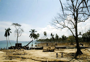
“Chicago exhibit looks at tsunami’s impact”
January 01, 2006, The Charlotte Observer, USA:
“The photo depicts a crowd of new boats pulled up to shore, their brilliant blue and red paint jobs shiny in the sun. But on land, last year’s tsunami’s devastation is still evident — a coastline devoid of trees, a shack in falling apart.
‘It’s in some ways very hopeful, but even a year afterward, it really shows that there’s more to be done,’ said Mike Sarna, director of exhibits at The Notebaert Nature Museum.
The photograph is part of a new exhibit at the museum, called ‘Tsunami: Science and Hope’, that centers around the earthquake-spawned tidal waves on Dec. 26, 2004, that left at least 216,000 people dead or missing in 12 Indian Ocean nations.”
[Full Story]
|