|
links about
– tsunami –
DigitalGlobe is making more high-resolution satellite images available to media for free; this set is from the Banda Aceh shore in Indonesia:
Tsunami Satellite Photos
A study of the danger to coastal settlements in Australia from the threat of tsunami is available at:
The Tsunami Papers
Other interesting links for more information about tsunami are listed below:
Tsunami from Asteroid/Comet Impacts
Science of Tsunami
Hazards
Two Decades of Global Tsunamis
1982 – 2002
Simulation of
Impact Tsunami
Washington University
Tsunami page
Pacific Tsunami Museum, Hawaii
Asteroid Tsunami
National Oceanic
& Atmospheric Administation
Tsunami page
A Selection of Books About:
Tsunami
Tidal Waves
Earthquakes
Volcanoes

“Tsunamis in the
Mediterranean Sea
2000 BC-2000AD”
Sergei Leonidovich
Solovev (Editor)
Olga N. Solovieva
Chan N. Go
Khen S. Kim
Nikolay A. Shchetnikov
Sergey L. Soloviev

EU English Edition
“The founder and recognized leader of the Russian scientific school of tsunami researchers Sergey (1930-94) and his collaborators describe in detail the waves generated by earthquakes and accompanying phenomena in a region prone to earthquakes and where the written record allows a study of four millennia. Most of the material is quantitative information, including coordinates of the observation sites, dates, heights of tsunami run-ups, main parameters of the earthquakes, and tide gauge records. That is augmented by the electronic database created in the Tsumani Laboratory, Institute of Computational Mathematics and Mathematical Geophysics in Novosibirsk. Only geographical names are indexed.
“Tsunami: Monster Waves (American Disasters)”
Mary Dodson Wade
Janet Hamilton

EU English Edition
“Grade 4-7-Tsunamis, although not common, hold a fascination for both shore dwellers and inland inhabitants. The idea of a huge wave coming suddenly with little warning and capable of major devastation is both awesome and horrifying. This pedestrian book capitalizes on the destructive nature of these great waves.”
“Tidal Waves Wash Away Cities”
Kate Petty
EU English Edition
“Kids in grades 1-3 will enjoy this set of simple yet entertaining facts about tidal waves: from underwater volcanic action to tidal action and ocean problems, this packs in details about tidal waves and their effects on human habitation with over 30 pages including a glossary and bright photos set against black pages.”
“Landslides and Tsunamis”
Barbara Keating, Christopher Waythomas &
Alastair Dawson
EU English Edition
“The study of tsunamis has been shifting away from theoretical modeling of tsunami source, wave propagation and runup toward multidisciplinary investigations, with an emphasis on field studies. This collection of papers highlights the many approaches being utilized to study landslides and tsunamis.”
“Caribbean Tsunamis:
A 500-year History from 1498 – 1998″
Karen Fay O`Loughlin, James F. Lander (Editor)

EU English Edition
“In the past 500 years, the Caribbean region has had devastating tsunamis causing incalculable damage. It is an area of relatively high seismicity, and although tsunamis are not the chief natural hazard, they have the potential to produce catastrophic regional disasters.
“Today the necessity for awareness is of paramount importance. Tectonic forces continually build stress – until the inevitable release of strain that may trigger a tsunamigenic earthquake. The lack of a major tsunami in the past 57 years is due to a relative lack of relief of built-up energy, and the potential extent of the stress release grows as time elapses. The long period without relief of seismic stress buildup only increases the ominous threat of a devastating tsunami that could result from a sudden seafloor cataclysm.
|
|
The links below are to pages that will give you more information on tsunami – the giant tidal waves that can be caused by undersea earthquakes, volcanoes, landslides, and, as it has recently been realised, by the impacts of asteroids, comets and meteorites in the oceans. Their incredible destructive power has been responsible for the sweeping away of many coastal towns, villages, and inundating huge landmasses throughout history and prehistory.
Following tsunami there is often very little evidence left for future archæologists to discover, and it is highly probable that much of the evidence of civilisation near coastal areas in prehistoric times has simply been wiped away by these incredible forces of nature.
One recent study has discovered that, according to radiocarbon dating of sediments from the area, a ‘giant tsunami’ hit the eastern coast of Scotland in 5,800 BC. Stone tools found in the sand off Inverness showed that the waves hit the area without warning following a landslide off Storegga in north-west Norway.
Professor Smith, of the Department of Geography at Coventry University, told
BBC News Online:
“It looks as if those people were happily sitting in their camp when this wave from the sea hit the camp. Professor Smith of the department of Geography at Coventry University told BBC News Online. We’re talking about two, three or four large waves followed by little ones, that would have been 5-10 metres high. These waves do strike with such force that they are very destructive. It’s like being hit by an express train’.”
A little further south, on Moel Tryfan in North Wales, the mashed and mangled remains of marine molluscs (sea-shells) have been found in so-called ‘Ice-Age drift deposits’ supposedly left there when the ice-sheets melted and retreated back towards the North Pole. But the composition of the supposed ice-sheet deposits told another story.
In their book “Cataclysm: Compelling Evidence of a Cosmic Catastrophe in 9,500 BB”, an academic study of the evidence suggesting that the flood myths of ancient times were based on archaic memories of a ‘real global tsunami’, or ‘deluge’, and which challenges the orthodox interpretation of geological history descending from the notions of a Pleistocene Ice Age theorised by Louis Agassiz in the 1820s, authors D. S. Allan and J. B. state:
“Eroded and fragmentary shells occur within the ‘drift’ deposits on Moel Tryfaen, a mountain in North Wales rising 1,300ft (400m) above sea level. Perplexingly the species represented include not only northern but also temperate and southern forms adapted to very varied habitats. Some required deep and others shallow water, some sandy and others muddy water, and some were peculiar to shingly and others to a bare rocky environment.
In stating that ice could never have brought together so varied a molluscan assemblage as this, it is hardly necessary to add that water could have – in which case the enveloping drift’ deposits must have been similarly water-borne.”
In fact many of the ‘peculiarities’ conventionally attributed to an Ice Age simply could not have been created by the supposed advance and retreat of ice-sheets. Yet, if the many and various ‘flood-myths’ of antiquity, which have been passed down through millennia in the oral traditions of peoples worldwide, are based on true recollections of an ‘archaic deluge’, a catastrophic mega-tsunami could well have produced ALL of the phenomena now attributed to an Ice Age.
These would include:
-
the global distribution of ‘erratic boulders’ – especially in the latitudes which even the die-hard glaciologists admit were not covered with ice-sheets …
-
the multi-zone distribution of flora, fauna and marine life-forms in the composition of so-called ‘glacial drift’ in areas where no ice-sheets are even claimed to have existed …
-
and also in the pitiful conglomerations of broken and twisted remains of animals, birds, fish, trees and plants, pebbles, dirts and clays which can be found in caves and rock crevices in many areas around the world – not to mention the remains of whales and other sea creatures found on mountaintops – irrespective of theorised Pleistocene ice-sheet coverage …
NONE of these supposed ‘Ice Age Peculiarities’ could have been achieved solely by the action of Ice moving horizontally across hilly terrains. The nature of Ice is such that it cannot move uphill, and, as recent scientific surveys have concluded that there were never any huge mountains at the North Pole for ice-sheets to have slid down, ONLY the turbulent waters of mega-tsunami could have brought together such jumbles of life-forms, and forcibly jammed them into the small, tight places we find them today …
Was there really an Ice Age?
Or are the Deluge Traditions and Flood Myths of antiquity based on a sounder ancient science:
Tsunami
One of the best resources for understanding the
December 2004 Tsunami tragedy is the
Sydney Morning Herald’s
Interactive Tsunami Map
Official Tsunami Monitoring Centres :
International Tsunami Information Centre
Yuzhno-Sakhalinsk Tsunami Warning Center
National Geophysical Data Center – Tsunami Database
NOAA Tsunami Research Center
FEMA Fact Sheet: Tsunami
West Coast & Alaska Tsunami Warning Center
–
Latest Tsunami Bulletin
–
Pacific Tsunami Warning Center
–
Latest Tsunami Bulletin
–
Recorded Recent Tsunami
below are some details from a selection of recent stories in
our News Headlines Archive in latest date order
…
“Indian Ocean Tsunami Warning – evacuations in progress”
September 12, 2007, NOAA Pacific Tsunami Warning Center:
“TSUNAMI BULLETIN NUMBER 001
PACIFIC TSUNAMI WARNING CENTER/NOAA/NWSM
ISSUED AT 1124Z 12 SEP 2007
THIS BULLETIN IS FOR ALL AREAS OF THE INDIAN OCEAN … AN INDIAN-OCEAN-WIDE TSUNAMI WATCH IS IN EFFECT …
A TSUNAMI WATCH IS IN EFFECT FOR:
INDONESIA / AUSTRALIA / INDIA / SRI LANKA / THAILAND /
UNITED KINGDOM / MALDIVES / MYANMAR / MALAYSIA / BANGLADESH /
MAURITIUS / REUNION / SEYCHELLES / MADAGASCAR / SOMALIA / OMAN /
PAKISTAN / IRAN / YEMEN / COMORES / CROZET ISLANDS /
MOZAMBIQUE / KENYA / TANZANIA / KERGUELEN ISLANDS /
SOUTH AFRICA / SINGAPORE
AN EARTHQUAKE HAS OCCURRED WITH THESE PRELIMINARY PARAMETERS:
ORIGIN TIME – 1110Z 12 SEP 2007
COORDINATES – 4.5 SOUTH 101.3 EAST
LOCATION – SOUTHERN SUMATERA INDONESIA
MAGNITUDE – 7.9
EVALUATION:
EARTHQUAKES OF THIS SIZE HAVE THE POTENTIAL TO GENERATE A WIDESPREAD DESTRUCTIVE TSUNAMI THAT CAN AFFECT COASTLINES ACROSS THE ENTIRE INDIAN OCEAN BASIN.
HOWEVER – IT IS NOT KNOWN THAT A TSUNAMI WAS GENERATED. THIS WATCH IS BASED ONLY ON THE EARTHQUAKE EVALUATION. AUTHORITIES IN THE REGION SHOULD TAKE APPROPRIATE ACTION IN RESPONSE TO THE POSSIBILITY OF A WIDESPREAD DESTRUCTIVE TSUNAMI.”
[Full Text of Warning]
“Dredging out past tsunamis”
September 02, 2007, The Sunday Times, Sri Lanka:
“Two major tsunamis or storms had hit Kirinda 2,200 years and 1,600 years ago, a team of scientists have discovered through dating layers of sand deposits from the estuary in Kirinda.
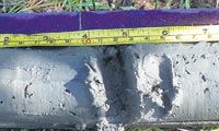
As night envelopes Hambantota, three men clad in shorts wade into the Kirinda estuary and in the subdued red glow of a torch, with feet squelching mud, press a long pipe deep into the depths of the estuary bed.
The Sunday Times, Sri Lanka
Collecting three metres of sediment, with a ‘corer’ they tenderly lift it out and pack the contents into S-lon tubes, ‘like making pittu’, still working in the dim torchlight, to which the eyes have to take about half-an-hour to adjust.
The process is repeated and several sediment samples well-wrapped in black polythene, so as not to expose the contents to light, are transported to Colombo.
As they study the samples once again in dim light, in the laboratory of the Central Cultural Fund, the excitement is tangible. Yes, the layers were visible. Amidst the mud were three clear layers of sand, says Dr. Mohan Abeyratne, the Director of Scientific Research of the Central Cultural Fund (CCF).
It was a tsunami study of a different kind that the CCF team comprising Dr. Abeyratne and Research Scientist (Geology), Pathmakumara Jayasingha and Ashok Kumara of the Post-Graduate Institute of Archaeology, were carrying out.”
[Full Story]
“Tsunami-triggering meteorite blasted Sudbury crater: scientists”
August 30, 2007, The Gazette, Canada:
“A mountain-sized meteorite appears to have created Sudbury’s gigantic crater and sent a tsunami racing though ancient oceans, say scientists who have uncovered a thick layer of debris the extraterrestrial interloper hurled all the way into Michigan.
A Canadian-U.S. team says the two-to-four-metre-thick layer of ‘ejecta’, which they found south of Lake Superior, bears the clear signature of a meteorite.
Perhaps even more intriguing, they say the ejecta appears to have been stirred up by a ‘mega-tsunami’, possibly two, that swept through the ancient oceans after the space rock hit.
‘The material blown out of the crater was reworked during deposition by a tsunami’, says Peir Pufahl, lead author of a report on the find in the September editions of the journal Geology.”
[Full Story]
“Tsunami quake likely in the Middle East, study shows”
August 10, 2007, Ya Libnan, Lebanon:
“In A.D. 551, a massive earthquake spawned huge tsunamis that devastated the coast of Phoenicia, now Lebanon.
Now a new underwater survey has finally uncovered the fault likely responsible for the catastrophe and shown that it rumbles approximately every 1,500 years—which means a disaster is due any day now.
‘It is just a matter of time before a destructive tsunami hits this region again’, said Iain Stewart, an earthquake expert at the University of Plymouth in the United Kingdom not involved in the underwater survey.
The ample archaeological and historical evidence from the A.D. 551 earthquake indicate that it was truly a catastrophic event. The resulting tsunami damaged all major coastal cities between Tripoli and Tyr, and Tripoli was reported to have ‘drowned’.“
[Full Story]
“Locals fear tsunami after PNG volcano reports”
May 22, 2007, Radio Australia:
“Reports from Papua New Guinea say thousands of people on an island off the northeast coast have fled to higher ground fearing a tsunami.
According to newspaper reports, locals say a nearby volcano erupted and forced the sea to rise dramatically, destroying several houses.”
[Full Story]
“Huge waves that hit Reunion Island tracked from space”
May 16, 2007, ESA Observing the Earth, France:
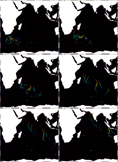
“The origin and movement of waves reaching up to 11 metres that devastated France’s Reunion Island in the Indian Ocean on Saturday evening have been detected with ESA’s Envisat satellite.
|
ESA, France
|
|
The waves that thrashed the southern port of Saint Pierre, leaving two fishermen missing, causing several piers to collapse and flooding several homes and businesses, originated south of Cape Town, South Africa, and travelled northeast for nearly 4000 km over a period of three days before slamming into Reunion Island.
|
Dr Bertrand Chapron of IFREMER, the French Research Institute for Exploitation of the Sea, and Dr Fabrice Collard of France’s BOOST Technologies in Brest located and tracked the swells using standard processed Synthetic Aperture Radar (SAR) ESA products.
‘Swells are still surprise factors, which can unfortunately be deadly’, Chapron said. ‘The SAR Wave Mode product allows us to locate and systematically track swells globally. In the near future we anticipate using SAR wave data to predict their arrival time and intensity.’
Although waves were forecast to hit Reunion Island, their intensity was predicted to be only a couple of metres, Collard explained.”
[Full Story]
“Waves From Chilean Earthquake Kill 3”
April 23, 2007, Nevada Appeal, USA:
“An earthquake triggered deadly 25-foot waves this weekend in southern Chile, killing at least three people.
The quake unleashed a landslide that tumbled into a narrow, remote fjord. The huge waves that resulted swept away 10 beachgoers. Three bodies have been found, and the search continues for the others.
One official said there were boats in the area, and they were destroyed. One boat reportedly ended up on top of a tree.
Saturday’s quake was the strongest of hundreds that have shaken that part of southern Chile since Jan. 22. Authorities believe it’s related to formation of a new undersea volcano.”
[Full Story]
“The wave that destroyed Atlantis”
April 20, 2007, BBC Science News, UK:
“The legend of Atlantis, the country that disappeared under the sea, may be more than just a myth. Research on the Greek island of Crete suggests Europe’s earliest civilisation was destroyed by a giant tsunami.
Until about 3,500 years ago, a spectacular ancient civilisation was flourishing in the Eastern Mediterranean. The ancient Minoans were building palaces, paved streets and sewers, while most Europeans were still living in primitive huts.
But around 1500BC the people who spawned the myths of the Minotaur and the Labyrinth abruptly disappeared. Now the mystery of their cataclysmic end may finally have been solved.
How it might have looked as the wave approached the town

BBC Science News
A group of scientists have uncovered new evidence that the island of Crete was hit by a massive tsunami at the same time that Minoan culture disappeared.
‘The geo-archaeological deposits contain a number of distinct tsunami signatures’, says Dutch-born geologist Professor Hendrik Bruins of the Ben-Gurion University of the Negev in Israel.
‘Minoan building material, pottery and cups along with food residue such as isolated animal bones were mixed up with rounded beach pebbles and sea shells and microscopic marine fauna.’
‘The latter can only have been scooped up from the sea-bed by one mechanism – a powerful tsunami, dumping all these materials together in a destructive swoop’, says Professor Bruins. “
[Full Story]
“Tracking traces of the Tahoe tsunami”
February 25, 2007, Nevada Appeal, USA:
“Coming off a ground-breaking Tahoe tsunami research year, scientists are planning for a new season of underwater science, one they hope will pinpoint the date of a past monster wave.
Along the way they will investigate the potential for a tsunami in Tahoe’s future, including analyzing the strength and stability of steep rock walls along the lake, which could collapse and cause another huge wave.
Last year, scientists believed they found definitive proof that a huge landslide caused approximately 100-foot waves to wash over what is now Tahoe City, sometime within the last 20,000 years or so.
This summer, the clue-finding will continue, aided by a remote-controlled submarine named Triton, which has served as underwater eyes for a conglomeration of scientists. The submersible comes from Santa Clara University, and is used from Antarctica to Japan for underwater observations. University of Nevada, Reno Geology Professor Richard Schweickert said the team will search for remnants of ancient, underwater forests that may help date the last Tahoe wave.”
[Full Story]
“Fears storm surge could breach coastal defences”
February 08, 2007, Dorset Daily Echo, England:
“SOUTHBOURNE residents have warned of a ‘disaster waiting to happen’ if more action isn’t taken to protect Hengistbury Head from coastal erosion.
A storm surge during extreme weather could force a breach through the vulnerable ancient site, they say, flooding homes and businesses in areas such as Wick, Tuckton, Christchurch, Stanpit and Mudeford.
Beach replenishment undertaken a year ago has already been washed away, say members of the Hengistbury Residents’ Association (Henra).
And they warn that depositing more material on the shore will be a ‘waste of time and money’ unless the groynes are urgently improved and other coastal protection work carried out.”
[Full Story]
“The great flood of 1607”
January 30, 2007, BBC Bristol, England:
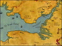
“Four hundred years ago, in the reign of James I of England, a disaster hit the south west of the country, as a huge surge of water coursed up the Bristol Channel – covering 200 square miles of land with water and killing 2,000 people.
|
BBC Bristol
Blue shading shows flooded areas
|
|
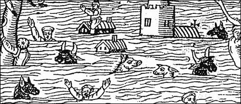
Eyewitness accounts of the great flood of 30 January 1607 tell of ‘huge and mighty hills of water’ advancing at a speed ‘faster than a greyhound can run’ and only receding 10 days later.
The flood reached a speed of 30mph and a height of 25ft.
|
It swept up to four miles inland in the Bristol area, north Devon, Pembrokeshire, Glamorgan, Monmouthshire and Cardiff – and up to 14 miles inland in low-lying parts of Somerset. But it is still not certain exactly what sparked the disaster which killed so many.
For centuries it was thought high tides and severe storms were to blame, a theory accepted by Dr Kevin Horsburgh from the Proudman Oceanographic Laboratory in Liverpool, who said a massive storm surge, formed by a combination of high tides and hurricane winds, may have been to blame.
|
BBC Bristol
|
But a tsunami theory was put forward by experts from Bath and Australia in 2004, supported by evidence of deposits of sand, pebbles and shell at various locations around the Severn Estuary where flood waters swept in, including Hill in South Gloucestershire.
It’s believed these deposits may have been brought in from the open ocean.”
[Full Story]
“Anniversary of 1607 killer wave”
January 30, 2007, BBC News Online, UK:
“A suspected tsunami in the Bristol Channel which killed 2,000 people happened 400 years ago on Tuesday.
Experts believe severe flooding on 30 January 1607 in south west England and south Wales was caused by a tsunami – and not a storm surge or high tides. It is estimated 200 square miles (520 sq km) of land were covered by water.
Simon Hasslett from Bath Spa University said there was currently no tsunami warning system in place. He said the research was important for informing coastal and risk management plans.
The flood of 1607 has been described by experts as the worst natural disaster to hit Britain. Eyewitness accounts of the disaster told of ‘huge and mighty hills of water’ advancing at a speed ‘faster than a greyhound can run’.”
[Full Story]
|
|
To understand why this News Page is sometimes late here is some information about Fibromyalgia
if you would like to support our
Marine Archaeology Research
please send us a book

from our Wish List
Ancient Mysteries
Bookshoppe
for a wide selection of
books that challenge
orthodox views of
prehistory on
our planet :
“Eden in the East: The Drowned Continent of Southeast Asia”
Stephen Oppenheimer

EU English Edition
“A book that completetly changes the established and conventional view of prehistory by relocating the Lost Eden – the world’s 1st civilization – to SouthEast Asia. At the end of the Ice Age, SouthEast Asia formed a continent twice the size of India, which included Indochina, Malaysia, Indonesia and Borneo.
The South China Sea, the Gulf of Thailand and the Java sea, which were all dry, formed the connecting parts of the continent. Geologically, this half sunken continent is the Shunda shelf or Sundaland.
He produces evidence from ethnography, archaeology, oceanography, from creation stories, myths and sagas and from linguistics and DNA analysis, to argue that this founder civilization was destroyed by a catastrophic flood, caused by a rapid rise in the sea level at the end of the last ice age.”
“Red, Earth, White Lies: Native Americans & the Myth of Scientific Fact”
Vine Deloria

EU English Edition
“Leading Native American scholar and author of the best-selling books God Is Red and Custer Died for Your Sins, Vine Deloria, Jr., addresses the conflict between mainstream scientific theory about the world and the ancestral worldview of Native Americans. Claiming that science has created a largely fictional scenario for American Indians in prehistoric North America, Deloria offers an alternative view of the continent’s history as seen through the eyes and memories of Native Americans.
“The World Almanac and Book of Facts”
Ken Park (Editor)

EU English Edition
extracts from pages
in the book:
“… systems can drive ocean water inland and cause significant flooding. Coastal floods can also be produced by sea waves called tsunamis, sometimes referred to as tidal waves: these waves are produced by earthquakes or volcanic activity
“… of the volcano collapsed to 1,000 ft below sea level, sinking most of the island and killing over 3,000. A tsunami (tidal wave) generated by the collapse killed more than 31,000 people in Java and Sumatra, and eventually reached England.”
“Furious Earth: The Science and Nature of Earthquakes, Volcanoes, and Tsunamis”
Ellen J. Prager
EU English Edition
from the back cover:
“The Science Behind the Earth’s Most Catastrophic Phenomena. If our planet is a sleeping giant, it slumbers fitfully and awakens in powerful starts. Our familiar landscape bears the scars f hidden forces at work deep beneath it. Furious Earth contains the latest science on these forces and the cataclysmic phenomena they produce – earthquakes, volcanoes, and tsunamis.
Now, hard-won knowledge of these phenomena, gained often in the aftermath of disaster or through dangerous research efforts, is presented here by scientist Ellen Prager with the following experts: Stanley Willaims, Ph.D. Professor of Volcanology, Arizona State University, on volcanoes; Kate Hutton, Ph.D., Seismologist, California State Institute of Technology, on earthquakes; Costas Synolakis, Ph.D., Professor of Civil Engineering, University of Southern California, on tsunamis.”
Japan’s Mysterious Pyramids: YONAGUNI

Do undersea relics near Okinawa offer proof of a sophisticated civilization during the last ice age?
www.historychannel.com
A Further Selection Of Books About:
Tsunami
Tidal Waves
Earthquakes
Volcanoes
|